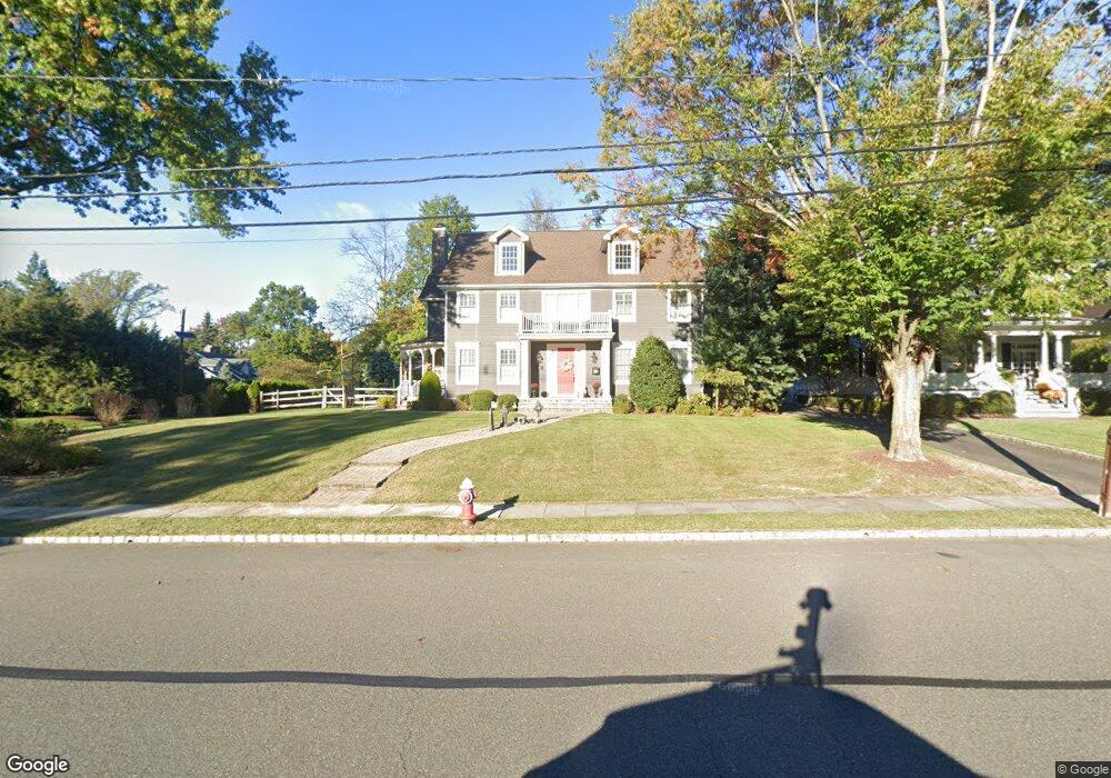
552 Elm St Westfield, NJ 07090
Estimated Value: $1,905,000 - $2,000,000
4
Beds
3
Baths
3,215
Sq Ft
$609/Sq Ft
Est. Value
About This Home
This home is located at 552 Elm St, Westfield, NJ 07090 and is currently estimated at $1,958,518, approximately $609 per square foot. 552 Elm St is a home located in Union County with nearby schools including Franklin Elementary School, Roosevelt Intermediate School, and Westfield Senior High School.
Ownership History
Date
Name
Owned For
Owner Type
Purchase Details
Closed on
Jun 21, 2017
Sold by
Howard Brett and Howard Lisa
Bought by
Minardo Philip and Minardo Minardo
Current Estimated Value
Home Financials for this Owner
Home Financials are based on the most recent Mortgage that was taken out on this home.
Original Mortgage
$1,100,000
Outstanding Balance
$914,971
Interest Rate
4.02%
Mortgage Type
New Conventional
Estimated Equity
$1,043,547
Purchase Details
Closed on
Nov 25, 2009
Sold by
Ball Robert F and Ball Adele C
Bought by
Howard Brett and Howard Lisa
Home Financials for this Owner
Home Financials are based on the most recent Mortgage that was taken out on this home.
Original Mortgage
$850,000
Interest Rate
5.01%
Mortgage Type
New Conventional
Purchase Details
Closed on
Oct 8, 2004
Sold by
Didell Eric
Bought by
Ball Robert and Ball Adele
Home Financials for this Owner
Home Financials are based on the most recent Mortgage that was taken out on this home.
Original Mortgage
$600,000
Interest Rate
5.8%
Create a Home Valuation Report for This Property
The Home Valuation Report is an in-depth analysis detailing your home's value as well as a comparison with similar homes in the area
Home Values in the Area
Average Home Value in this Area
Purchase History
| Date | Buyer | Sale Price | Title Company |
|---|---|---|---|
| Minardo Philip | $1,375,000 | Acres Land Title Agency Llc | |
| Howard Brett | $1,325,000 | Chicago Title Insurance Co | |
| Ball Robert | $807,500 | -- |
Source: Public Records
Mortgage History
| Date | Status | Borrower | Loan Amount |
|---|---|---|---|
| Open | Minardo Philip | $1,100,000 | |
| Previous Owner | Howard Brett | $850,000 | |
| Previous Owner | Ball Robert | $600,000 |
Source: Public Records
Tax History Compared to Growth
Tax History
| Year | Tax Paid | Tax Assessment Tax Assessment Total Assessment is a certain percentage of the fair market value that is determined by local assessors to be the total taxable value of land and additions on the property. | Land | Improvement |
|---|---|---|---|---|
| 2025 | $30,548 | $1,356,500 | $703,400 | $653,100 |
| 2024 | $29,924 | $1,356,500 | $703,400 | $653,100 |
| 2023 | $29,924 | $1,356,500 | $703,400 | $653,100 |
| 2022 | $29,300 | $1,356,500 | $703,400 | $653,100 |
| 2021 | $29,341 | $1,356,500 | $703,400 | $653,100 |
| 2020 | $29,273 | $1,356,500 | $703,400 | $653,100 |
| 2019 | $29,165 | $1,356,500 | $703,400 | $653,100 |
| 2018 | $26,682 | $287,000 | $95,700 | $191,300 |
| 2017 | $26,536 | $287,000 | $95,700 | $191,300 |
| 2016 | $25,913 | $287,000 | $95,700 | $191,300 |
| 2015 | $25,397 | $287,000 | $95,700 | $191,300 |
| 2014 | $24,559 | $287,000 | $95,700 | $191,300 |
Source: Public Records
Map
Nearby Homes
- 559 Lawrence Ave
- 304 E Dudley Ave
- 740 Lawrence Ave
- 415 Highland Ave
- 143 Stanmore Place
- 303 Prospect St
- 517 Clark St
- 260 Prospect St Unit C15
- 819 Standish Ave
- 645 Kimball Ave
- 508 N Chestnut St
- 350 W Dudley Ave
- 724 South Ave W Unit 724A
- 869 Standish Ave
- 11 Mountainview Dr
- 766 Oak Ave
- 1463 Dunn Pkwy
- 113 Barchester Way
- 538 Westfield Ave
- 1163 Lawrence Ave