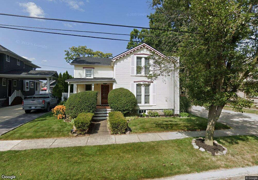
552 Maple St Plymouth, MI 48170
Estimated Value: $396,424 - $459,000
3
Beds
2
Baths
1,020
Sq Ft
$418/Sq Ft
Est. Value
About This Home
This home is located at 552 Maple St, Plymouth, MI 48170 and is currently estimated at $426,106, approximately $417 per square foot. 552 Maple St is a home located in Wayne County with nearby schools including Canton High School, Smith Elementary School, and East Middle School.
Ownership History
Date
Name
Owned For
Owner Type
Purchase Details
Closed on
Jun 30, 2006
Sold by
Yeskie Christopher H and Yeskie Julie M
Bought by
Armstrong Cynthia
Current Estimated Value
Home Financials for this Owner
Home Financials are based on the most recent Mortgage that was taken out on this home.
Original Mortgage
$100,000
Interest Rate
6.72%
Mortgage Type
New Conventional
Create a Home Valuation Report for This Property
The Home Valuation Report is an in-depth analysis detailing your home's value as well as a comparison with similar homes in the area
Home Values in the Area
Average Home Value in this Area
Purchase History
| Date | Buyer | Sale Price | Title Company |
|---|---|---|---|
| Armstrong Cynthia | $179,000 | H & H Title Inc |
Source: Public Records
Mortgage History
| Date | Status | Borrower | Loan Amount |
|---|---|---|---|
| Previous Owner | Armstrong Cynthia | $100,000 |
Source: Public Records
Tax History Compared to Growth
Tax History
| Year | Tax Paid | Tax Assessment Tax Assessment Total Assessment is a certain percentage of the fair market value that is determined by local assessors to be the total taxable value of land and additions on the property. | Land | Improvement |
|---|---|---|---|---|
| 2025 | $4,469 | $178,100 | $0 | $0 |
| 2024 | $4,469 | $157,400 | $0 | $0 |
| 2023 | $4,352 | $154,200 | $0 | $0 |
| 2022 | $4,613 | $145,400 | $0 | $0 |
| 2021 | $4,470 | $143,200 | $0 | $0 |
| 2020 | $4,459 | $147,800 | $0 | $0 |
| 2019 | $3,926 | $121,100 | $0 | $0 |
| 2018 | $3,813 | $116,200 | $0 | $0 |
| 2017 | $808 | $108,300 | $0 | $0 |
| 2016 | $4,154 | $102,900 | $0 | $0 |
| 2015 | $9,514 | $95,140 | $0 | $0 |
| 2013 | $11,036 | $115,170 | $0 | $0 |
| 2011 | -- | $105,240 | $0 | $0 |
Source: Public Records
Map
Nearby Homes
- 525 W Ann Arbor Trail
- 300 Hamilton St Unit 201
- 300 Hamilton St Unit 306
- 381 Hamilton St
- 628 Maple St
- 644 Maple St
- 636 Maple St
- 668 Maple St
- 660 Maple St
- 190 Hamilton St
- 730 Penniman Ave Unit 205
- 543 Deer St
- 163 Hamilton St
- 801 W Ann Arbor Trail Unit 306
- 278 Maple St
- 256 Maple St
- 42384 Gateway Dr
- 333 N Sydney Ct
- 364 N Sydney Ct
- 396 N Sydney Ct
- 528 Maple St
- 566 Maple St
- 506 Maple St
- 592 Maple St
- 509 W Ann Arbor Trail
- 543 Maple St
- 471 W Ann Arbor Trail
- 471 W Ann Arbor Trail
- 471 W Ann Arbor Trail
- 581 Maple St
- 606 Maple St
- 563 Maple St
- 523 Maple St
- 480 Maple St
- 585 Maple St
- 445 W Ann Arbor Trail
- 529 Kellogg St
- 624 Maple St
- 452 Maple St
- 483 Maple St