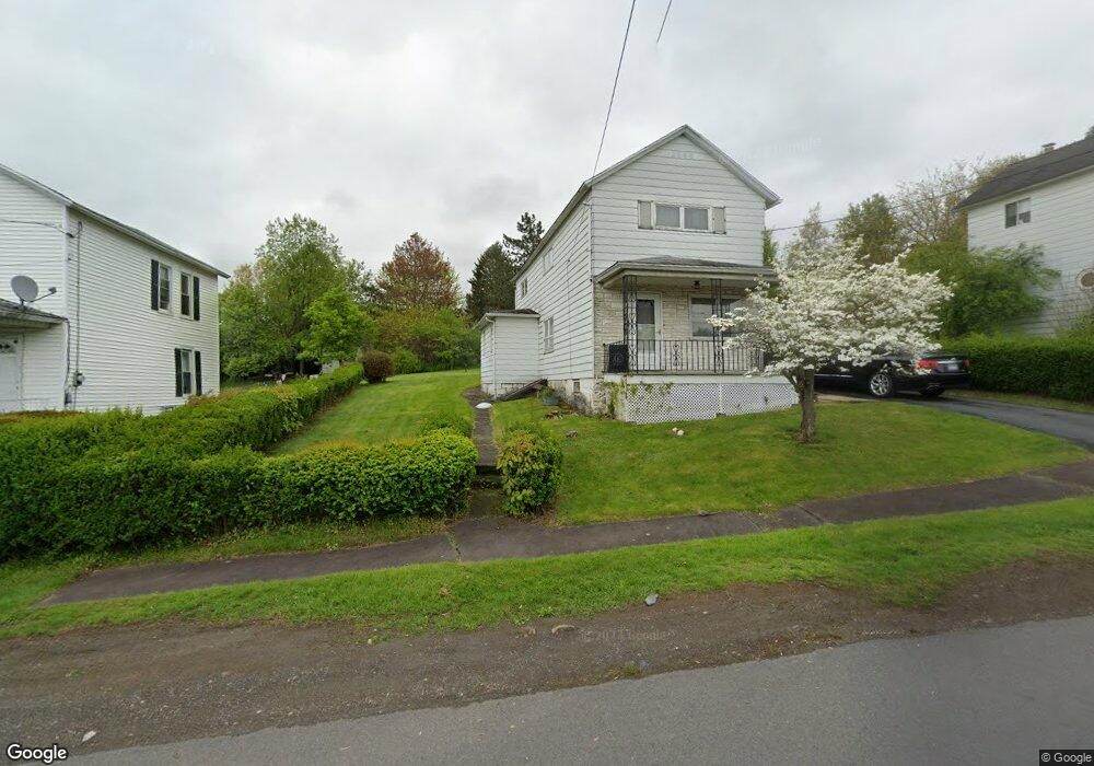
552 Pittston Ave Dupont, PA 18641
Estimated Value: $154,000 - $263,000
3
Beds
1
Bath
1,201
Sq Ft
$160/Sq Ft
Est. Value
About This Home
This home is located at 552 Pittston Ave, Dupont, PA 18641 and is currently estimated at $192,709, approximately $160 per square foot. 552 Pittston Ave is a home located in Luzerne County with nearby schools including Pittston City Intermediate Center, Pittston Area Middle School, and Frederick County Middle School.
Ownership History
Date
Name
Owned For
Owner Type
Purchase Details
Closed on
May 10, 2021
Sold by
Bartush Lorraine
Bought by
Bartush Lorraine and Frace Amanda Fonzo
Current Estimated Value
Purchase Details
Closed on
Jul 9, 2001
Bought by
Bartush Lorraine
Create a Home Valuation Report for This Property
The Home Valuation Report is an in-depth analysis detailing your home's value as well as a comparison with similar homes in the area
Home Values in the Area
Average Home Value in this Area
Purchase History
| Date | Buyer | Sale Price | Title Company |
|---|---|---|---|
| Bartush Lorraine | -- | None Available | |
| Bartush Lorraine | $85,000 | -- |
Source: Public Records
Tax History Compared to Growth
Tax History
| Year | Tax Paid | Tax Assessment Tax Assessment Total Assessment is a certain percentage of the fair market value that is determined by local assessors to be the total taxable value of land and additions on the property. | Land | Improvement |
|---|---|---|---|---|
| 2025 | $1,861 | $75,600 | $25,400 | $50,200 |
| 2024 | $1,861 | $75,600 | $25,400 | $50,200 |
| 2023 | $1,861 | $75,600 | $25,400 | $50,200 |
| 2022 | $1,847 | $75,600 | $25,400 | $50,200 |
| 2021 | $1,847 | $75,600 | $25,400 | $50,200 |
| 2020 | $1,805 | $75,600 | $25,400 | $50,200 |
| 2019 | $1,790 | $75,600 | $25,400 | $50,200 |
| 2018 | $1,753 | $75,600 | $25,400 | $50,200 |
| 2017 | $1,677 | $75,600 | $25,400 | $50,200 |
| 2016 | -- | $75,600 | $25,400 | $50,200 |
| 2015 | $1,322 | $75,600 | $25,400 | $50,200 |
| 2014 | $1,322 | $75,600 | $25,400 | $50,200 |
Source: Public Records
Map
Nearby Homes
- 0 Pittston Bypass
- 104 Serling St
- 132 Jackson St
- 212 Elm St
- 107 Holden St
- 202 Lidy Rd
- 224 Pittston Ave
- 533 Penn Ave
- 823 Mcalpine St
- 708 Mill St
- 523 Grove St
- 700 Suscon Rd
- 711 Grove St
- 422 Rockledge Dr
- 408 Rockledge Dr
- 420 Rockledge Dr
- 0 Reynolds St
- 305 Parsonage St
- 125 Mcalpine St
- Lot 32 Cremard Blvd
- 550 Pittston Ave
- 556 Pittston Ave
- 548 Pittston Ave
- 558 Pittston Ave
- 546 Pittston Ave
- 542 Pittston Ave
- 544 Pittston Ave
- 578 Rear Pittston Ave
- 560 Pittston Ave
- 540 Pittston Ave
- 304 Coolidge St
- 310 Coolidge St
- 302 Coolidge St
- 312 Coolidge St
- 314 Coolidge St
- 298 Coolidge St
- 538 Pittston Ave
- 0 Quail Hill Dr
- 296 Coolidge St
- 578 Pittston Ave