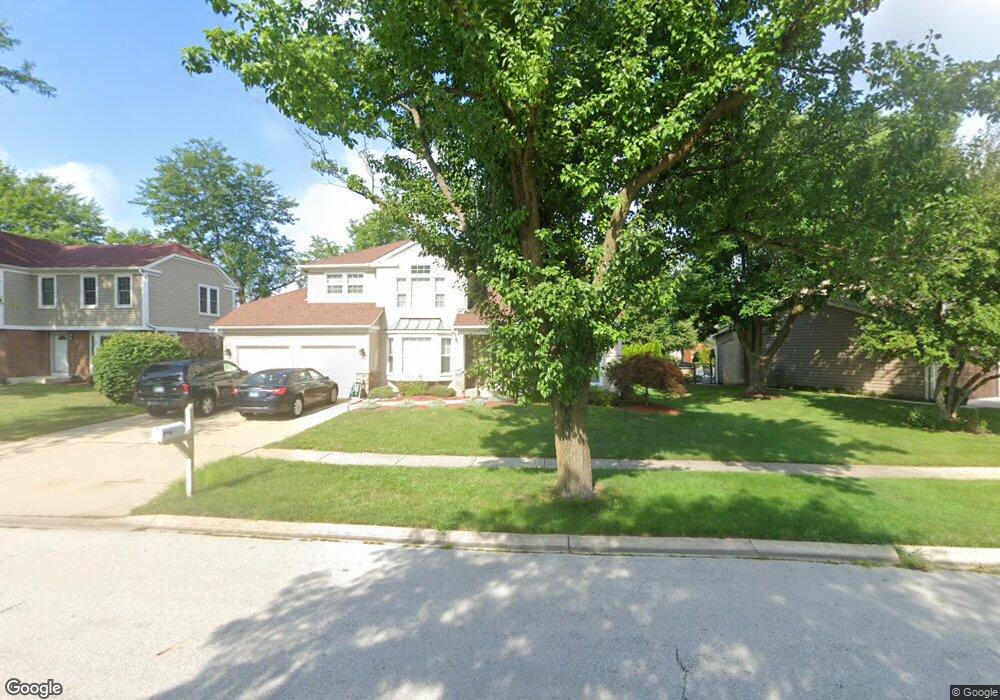
552 Rutgers Ln Elk Grove Village, IL 60007
Elk Grove Village West NeighborhoodEstimated Value: $630,000 - $681,000
4
Beds
3
Baths
2,518
Sq Ft
$259/Sq Ft
Est. Value
About This Home
This home is located at 552 Rutgers Ln, Elk Grove Village, IL 60007 and is currently estimated at $652,580, approximately $259 per square foot. 552 Rutgers Ln is a home located in Cook County with nearby schools including Frederick Nerge Elementary School, Margaret Mead Junior High School, and J B Conant High School.
Ownership History
Date
Name
Owned For
Owner Type
Purchase Details
Closed on
May 13, 2004
Sold by
Crail David S and Crail Cheryl L
Bought by
Berriman Robert A and Berriman Dorothy M
Current Estimated Value
Home Financials for this Owner
Home Financials are based on the most recent Mortgage that was taken out on this home.
Original Mortgage
$263,000
Outstanding Balance
$124,437
Interest Rate
5.63%
Mortgage Type
Unknown
Estimated Equity
$528,144
Create a Home Valuation Report for This Property
The Home Valuation Report is an in-depth analysis detailing your home's value as well as a comparison with similar homes in the area
Home Values in the Area
Average Home Value in this Area
Purchase History
| Date | Buyer | Sale Price | Title Company |
|---|---|---|---|
| Berriman Robert A | $405,000 | Multiple |
Source: Public Records
Mortgage History
| Date | Status | Borrower | Loan Amount |
|---|---|---|---|
| Open | Berriman Robert A | $263,000 |
Source: Public Records
Tax History Compared to Growth
Tax History
| Year | Tax Paid | Tax Assessment Tax Assessment Total Assessment is a certain percentage of the fair market value that is determined by local assessors to be the total taxable value of land and additions on the property. | Land | Improvement |
|---|---|---|---|---|
| 2024 | $12,400 | $46,000 | $13,893 | $32,107 |
| 2023 | $12,025 | $46,000 | $13,893 | $32,107 |
| 2022 | $12,025 | $46,000 | $13,893 | $32,107 |
| 2021 | $11,891 | $40,698 | $9,083 | $31,615 |
| 2020 | $11,658 | $40,698 | $9,083 | $31,615 |
| 2019 | $11,668 | $45,220 | $9,083 | $36,137 |
| 2018 | $11,835 | $41,324 | $7,748 | $33,576 |
| 2017 | $11,725 | $41,324 | $7,748 | $33,576 |
| 2016 | $11,191 | $41,324 | $7,748 | $33,576 |
| 2015 | $10,685 | $37,100 | $6,412 | $30,688 |
| 2014 | $10,561 | $37,100 | $6,412 | $30,688 |
| 2013 | $10,272 | $37,100 | $6,412 | $30,688 |
Source: Public Records
Map
Nearby Homes
- 725 Bismark Ct
- 1845 Maryland Dr
- 924 Surrey Dr Unit 1A
- 833 Thornton Ct Unit 2B
- 409 New York Ln
- 826 Thornton Ct Unit 2AL
- 1810 Hawk Ln
- 1224 Knottingham Ct Unit 1A
- 263 Doral Ct Unit 1
- 718 N Point Dr
- 932 Kentucky Ln
- 1124 Lovell Ct
- 1453 Armstrong Ln
- 160 Inverness Ct Unit A
- 722 Merlin Dr Unit 16
- 620 S Point Dr
- 1517 White Trail
- 1385 Scarboro Rd Unit 204
- 1386 Scarboro Rd Unit 1102
- 1022 Tennessee Ln