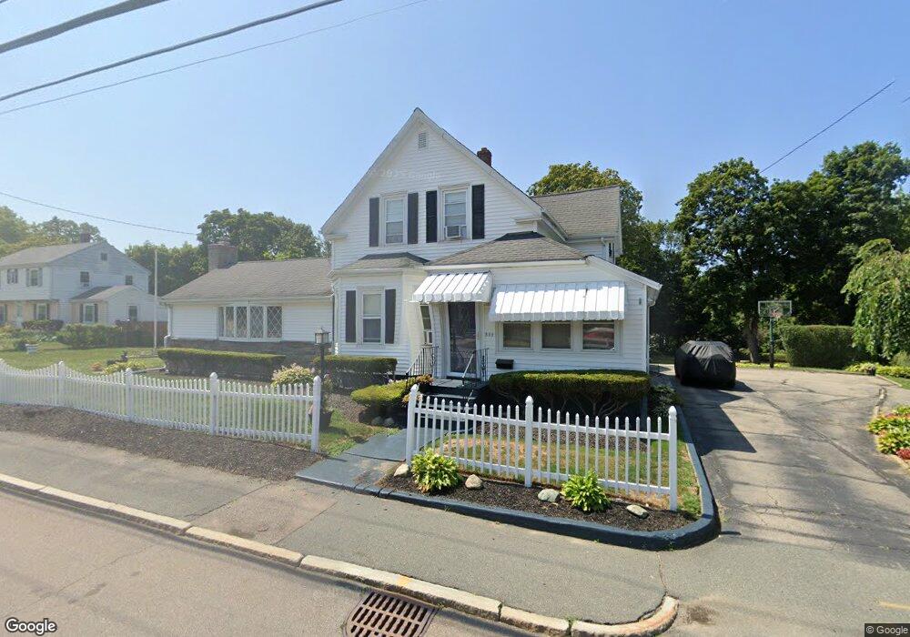
552 S Franklin St Holbrook, MA 02343
Estimated Value: $575,000 - $652,000
3
Beds
2
Baths
1,990
Sq Ft
$310/Sq Ft
Est. Value
About This Home
This home is located at 552 S Franklin St, Holbrook, MA 02343 and is currently estimated at $617,140, approximately $310 per square foot. 552 S Franklin St is a home located in Norfolk County with nearby schools including John F. Kennedy Elementary School, Holbrook Middle High School, and Boston Higashi School.
Ownership History
Date
Name
Owned For
Owner Type
Purchase Details
Closed on
Aug 27, 1998
Sold by
Dewolfe Robert F and Dewolfe Patricia A
Bought by
Harris Michael
Current Estimated Value
Home Financials for this Owner
Home Financials are based on the most recent Mortgage that was taken out on this home.
Original Mortgage
$150,818
Interest Rate
6.9%
Mortgage Type
Purchase Money Mortgage
Create a Home Valuation Report for This Property
The Home Valuation Report is an in-depth analysis detailing your home's value as well as a comparison with similar homes in the area
Home Values in the Area
Average Home Value in this Area
Purchase History
| Date | Buyer | Sale Price | Title Company |
|---|---|---|---|
| Harris Michael | $167,500 | -- | |
| Harris Michael | $167,500 | -- |
Source: Public Records
Mortgage History
| Date | Status | Borrower | Loan Amount |
|---|---|---|---|
| Open | Harris Michael | $239,878 | |
| Closed | Harris Michael | $176,000 | |
| Closed | Harris Michael | $150,818 |
Source: Public Records
Tax History Compared to Growth
Tax History
| Year | Tax Paid | Tax Assessment Tax Assessment Total Assessment is a certain percentage of the fair market value that is determined by local assessors to be the total taxable value of land and additions on the property. | Land | Improvement |
|---|---|---|---|---|
| 2025 | $70 | $528,800 | $234,700 | $294,100 |
| 2024 | $6,728 | $500,600 | $226,000 | $274,600 |
| 2023 | $7,099 | $461,600 | $201,800 | $259,800 |
| 2022 | $6,756 | $409,700 | $179,600 | $230,100 |
| 2021 | $6,626 | $384,800 | $167,900 | $216,900 |
| 2020 | $6,718 | $365,700 | $157,000 | $208,700 |
| 2019 | $7,002 | $359,800 | $156,900 | $202,900 |
| 2018 | $6,856 | $331,700 | $135,400 | $196,300 |
| 2017 | $6,475 | $309,800 | $123,400 | $186,400 |
| 2016 | $5,582 | $284,200 | $112,600 | $171,600 |
| 2015 | $5,342 | $280,000 | $115,000 | $165,000 |
| 2014 | $4,918 | $262,000 | $97,000 | $165,000 |
Source: Public Records
Map
Nearby Homes
- 610 S Franklin St Unit D304
- 34 Reeds Ln
- 41 Quincy St
- 18 Laurel Park
- 35 Rindone St
- 101 Quincy St
- 719 S Franklin St Unit L Block 1
- 719 S Franklin St Unit D Block 1
- 719 S Franklin St Unit C Block 1
- 375 S Franklin St Unit 1
- 19 Bradford St
- 27 Arnold St
- 13 Mayflower Rd
- 55 Border Rd
- 28 Border Rd
- 45 King Rd
- 12 Hawthorne Rd
- 14 Dale Rd
- 14 Fern Rd
- 27 Ell Rd
- 540 S Franklin St
- 545 S Franklin St
- 549 S Franklin St
- 558 S Franklin St
- 560 S Franklin St
- 1 Franklin Terrace
- 561 S Franklin St
- 561 S Franklin St Unit Two
- 530 S Franklin St
- 543 S Franklin St
- 3 Franklin Terrace
- 562 S Franklin St
- 541 S Franklin St
- 2 Franklin Terrace
- 3 Shirley Terrace
- 12 Franklin Terrace
- 20 Shirley St
- 539 S Franklin St
- 520 S Franklin St
- 520 S Franklin St Unit A