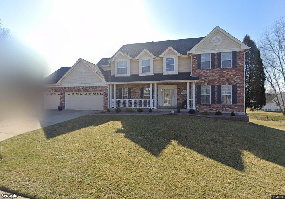
5524 Hennsley Cir Weldon Spring, MO 63304
Estimated Value: $540,000 - $676,000
4
Beds
3
Baths
2,904
Sq Ft
$214/Sq Ft
Est. Value
About This Home
This home is located at 5524 Hennsley Cir, Weldon Spring, MO 63304 and is currently estimated at $621,239, approximately $213 per square foot. 5524 Hennsley Cir is a home located in St. Charles County with nearby schools including Independence Elementary School, Francis Howell Middle School, and Francis Howell Union High School.
Ownership History
Date
Name
Owned For
Owner Type
Purchase Details
Closed on
Mar 27, 2002
Sold by
Neider Ronald L and Neider Erika Rosa
Bought by
Neider Ronald L and Neider Erika Rosa
Current Estimated Value
Home Financials for this Owner
Home Financials are based on the most recent Mortgage that was taken out on this home.
Original Mortgage
$186,000
Interest Rate
6.78%
Purchase Details
Closed on
Apr 8, 2000
Sold by
Neider Ronald L
Bought by
Neider Ronald L
Create a Home Valuation Report for This Property
The Home Valuation Report is an in-depth analysis detailing your home's value as well as a comparison with similar homes in the area
Home Values in the Area
Average Home Value in this Area
Purchase History
| Date | Buyer | Sale Price | Title Company |
|---|---|---|---|
| Neider Ronald L | -- | -- | |
| Neider Ronald L | -- | -- |
Source: Public Records
Mortgage History
| Date | Status | Borrower | Loan Amount |
|---|---|---|---|
| Closed | Neider Ronald L | $186,000 |
Source: Public Records
Tax History
| Year | Tax Paid | Tax Assessment Tax Assessment Total Assessment is a certain percentage of the fair market value that is determined by local assessors to be the total taxable value of land and additions on the property. | Land | Improvement |
|---|---|---|---|---|
| 2025 | $5,748 | $107,139 | -- | -- |
| 2023 | $5,745 | $96,478 | $0 | $0 |
| 2022 | $5,478 | $85,454 | $0 | $0 |
| 2021 | $5,483 | $85,454 | $0 | $0 |
| 2020 | $4,993 | $75,296 | $0 | $0 |
| 2019 | $4,970 | $75,296 | $0 | $0 |
| 2018 | $5,020 | $72,712 | $0 | $0 |
| 2017 | $4,978 | $72,712 | $0 | $0 |
| 2016 | $4,483 | $63,029 | $0 | $0 |
| 2015 | $4,445 | $63,029 | $0 | $0 |
| 2014 | $4,136 | $56,890 | $0 | $0 |
Source: Public Records
Map
Nearby Homes
- 5527 Hennsley Cir
- 5534 Wavecrest Cir
- 0 Gutermuth Rd
- 14 Walnut Hill Ct
- 323 Wildberry Ln
- 1317 Auburn Hills Dr
- 217 Bottlebrush Grove Ct
- 0 Universal Design Prairie Bluff Unit MAR24041208
- 114 Cottle Creek Way
- 106 Cottle Creek Way
- 1334 Auburn Hills Dr
- 301 Switchgrass Landing Ln
- 110 Cottle Creek Way
- 116 Cottle Creek Way
- 3009 Bruce Trail Ct
- 1 Belcourt Cir
- 3004 Bruce Trail Ct
- 136 Sweetgrass Point Way
- 1005 Waldo Ln
- 2018 Butte Trail Ct
- 5516 Hennsley Cir
- 5532 Hennsley Cir
- 5508 Hennsley Cir
- 5538 Hennsley Cir
- 5523 Hennsley Cir
- 5525 Hennsley Cir
- 5542 Hennsley Cir
- 5504 Hennsley Cir
- 5517 Hennsley Circle Ct
- 5521 Hennsley Cir
- 5509 Hennsley Cir
- 5546 Hennsley Cir
- 5531 Hennsley Cir
- 5535 Hennsley Cir
- 5505 Hennsley Cir
- 861 Dunbarton Dr
- 5539 Hennsley Cir
- 5544 Ashboro Dr
- 5542 Ashboro Dr
- 5546 Ashboro Dr
Your Personal Tour Guide
Ask me questions while you tour the home.