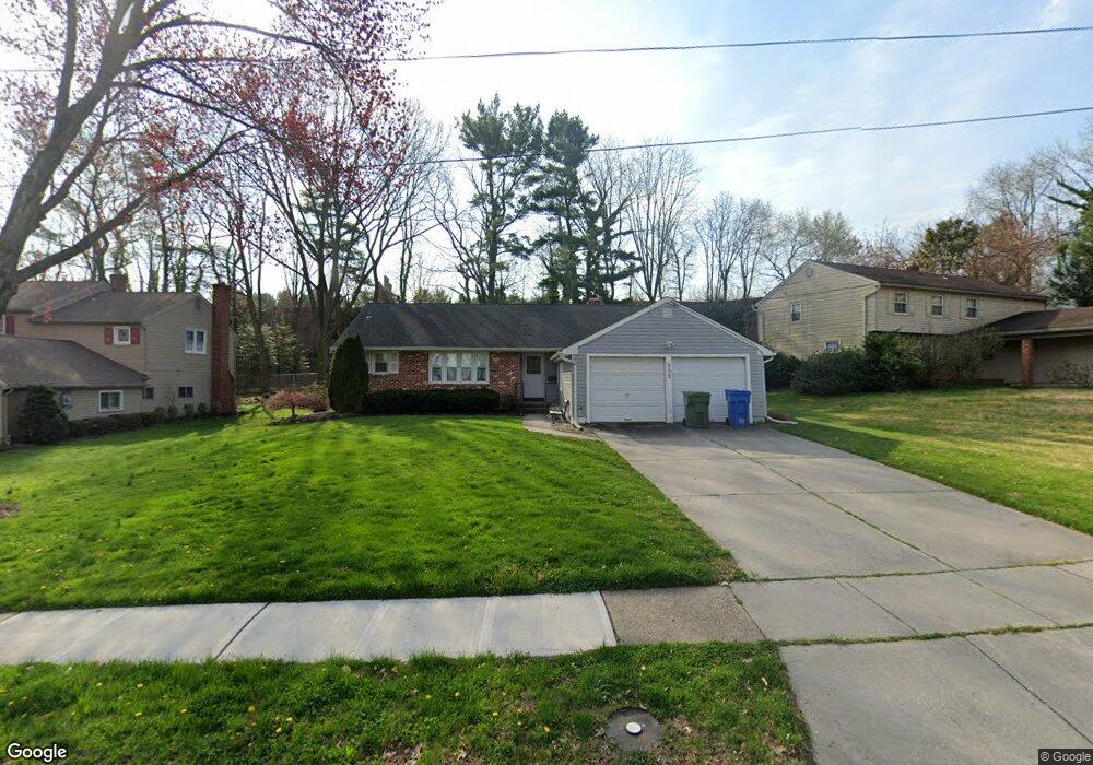
553 Covered Bridge Rd Cherry Hill, NJ 08034
Estimated Value: $498,221 - $533,000
--
Bed
--
Bath
1,666
Sq Ft
$307/Sq Ft
Est. Value
About This Home
This home is located at 553 Covered Bridge Rd, Cherry Hill, NJ 08034 and is currently estimated at $511,805, approximately $307 per square foot. 553 Covered Bridge Rd is a home located in Camden County with nearby schools including A. Russell Knight Elementary School, John A Carusi Middle School, and Cherry Hill High-West High School.
Ownership History
Date
Name
Owned For
Owner Type
Purchase Details
Closed on
Jan 3, 2006
Sold by
Sheldon Daniel
Bought by
Attinson Mark and Attinson Sandra
Current Estimated Value
Home Financials for this Owner
Home Financials are based on the most recent Mortgage that was taken out on this home.
Original Mortgage
$339,900
Interest Rate
6.14%
Mortgage Type
Purchase Money Mortgage
Purchase Details
Closed on
Jul 9, 2004
Sold by
Zane Ursuala
Bought by
Preston Karle R
Home Financials for this Owner
Home Financials are based on the most recent Mortgage that was taken out on this home.
Original Mortgage
$192,000
Interest Rate
6.33%
Mortgage Type
Purchase Money Mortgage
Create a Home Valuation Report for This Property
The Home Valuation Report is an in-depth analysis detailing your home's value as well as a comparison with similar homes in the area
Home Values in the Area
Average Home Value in this Area
Purchase History
| Date | Buyer | Sale Price | Title Company |
|---|---|---|---|
| Attinson Mark | $339,900 | -- | |
| Preston Karle R | $240,000 | -- |
Source: Public Records
Mortgage History
| Date | Status | Borrower | Loan Amount |
|---|---|---|---|
| Previous Owner | Attinson Mark | $339,900 | |
| Previous Owner | Preston Karle R | $192,000 |
Source: Public Records
Tax History Compared to Growth
Tax History
| Year | Tax Paid | Tax Assessment Tax Assessment Total Assessment is a certain percentage of the fair market value that is determined by local assessors to be the total taxable value of land and additions on the property. | Land | Improvement |
|---|---|---|---|---|
| 2025 | $9,270 | $207,900 | $68,100 | $139,800 |
| 2024 | $8,736 | $207,900 | $68,100 | $139,800 |
| 2023 | $8,736 | $207,900 | $68,100 | $139,800 |
| 2022 | $8,495 | $207,900 | $68,100 | $139,800 |
| 2021 | $8,522 | $207,900 | $68,100 | $139,800 |
| 2020 | $8,418 | $207,900 | $68,100 | $139,800 |
| 2019 | $8,414 | $207,900 | $68,100 | $139,800 |
| 2018 | $8,391 | $207,900 | $68,100 | $139,800 |
| 2017 | $8,277 | $207,900 | $68,100 | $139,800 |
| 2016 | $8,166 | $207,900 | $68,100 | $139,800 |
| 2015 | $8,037 | $207,900 | $68,100 | $139,800 |
| 2014 | $7,948 | $207,900 | $68,100 | $139,800 |
Source: Public Records
Map
Nearby Homes
- 1324 Charleston Rd
- 505 Fern Ave
- 119 W Riding Rd
- 515 Kresson Rd
- 1227 Cotswold Ln
- 1222 Sequoia Rd
- 102 Lane of Trees
- 314 Covered Bridge Rd
- 1217 Forge Rd
- 1010 Salem Rd
- 307 Provincetown Cir
- 1109 Winding Dr
- 300 Portsmouth Rd
- 117 Lucerne Blvd
- 112 Centura
- 174 Centura
- 144 Centura
- 109 Old Carriage Rd
- 217 Redstone Ridge
- 175 Mansfield Blvd N
- 557 Covered Bridge Rd
- 549 Covered Bridge Rd
- 545 Covered Bridge Rd
- 561 Covered Bridge Rd
- 550 Covered Bridge Rd
- 541 Covered Bridge Rd
- 554 Covered Bridge Rd
- 546 Covered Bridge Rd
- 118 Bentwood Dr
- 571 Tarrington Rd
- 542 Covered Bridge Rd
- 537 Covered Bridge Rd
- 572 Tarrington Rd
- 116 Bentwood Dr
- 538 Covered Bridge Rd
- 567 Tarrington Rd
- 119 Bentwood Dr
- 533 Covered Bridge Rd
- 568 Tarrington Rd
- 114 Bentwood Dr