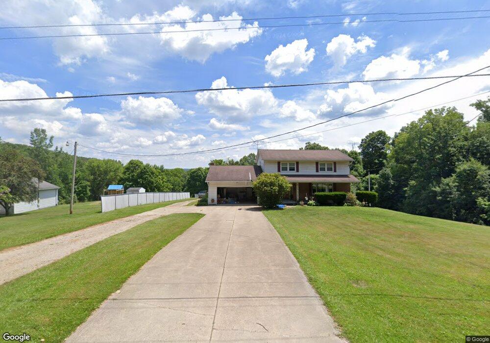
553 Pugh Rd Mansfield, OH 44903
Estimated Value: $294,000 - $368,000
3
Beds
3
Baths
2,316
Sq Ft
$142/Sq Ft
Est. Value
About This Home
This home is located at 553 Pugh Rd, Mansfield, OH 44903 and is currently estimated at $328,640, approximately $141 per square foot. 553 Pugh Rd is a home located in Richland County with nearby schools including Madison High School.
Ownership History
Date
Name
Owned For
Owner Type
Purchase Details
Closed on
Dec 9, 2011
Sold by
Wells Fargo Bank N A
Bought by
Smith Marianne and Smith James S
Current Estimated Value
Purchase Details
Closed on
Sep 27, 2011
Sold by
Hood Jason A
Bought by
Wells Fargo Bank N A
Purchase Details
Closed on
Mar 30, 2009
Sold by
Estate Of Beverly Louise Hood
Bought by
Hood Jason A
Create a Home Valuation Report for This Property
The Home Valuation Report is an in-depth analysis detailing your home's value as well as a comparison with similar homes in the area
Home Values in the Area
Average Home Value in this Area
Purchase History
| Date | Buyer | Sale Price | Title Company |
|---|---|---|---|
| Smith Marianne | $46,700 | Chicago Title | |
| Wells Fargo Bank N A | $70,000 | Attorney | |
| Hood Jason A | -- | None Available |
Source: Public Records
Tax History Compared to Growth
Tax History
| Year | Tax Paid | Tax Assessment Tax Assessment Total Assessment is a certain percentage of the fair market value that is determined by local assessors to be the total taxable value of land and additions on the property. | Land | Improvement |
|---|---|---|---|---|
| 2024 | $3,557 | $68,920 | $11,230 | $57,690 |
| 2023 | $3,557 | $68,920 | $11,230 | $57,690 |
| 2022 | $2,741 | $48,670 | $9,000 | $39,670 |
| 2021 | $2,740 | $48,670 | $9,000 | $39,670 |
| 2020 | $2,762 | $48,670 | $9,000 | $39,670 |
| 2019 | $2,499 | $41,060 | $7,560 | $33,500 |
| 2018 | $2,479 | $41,060 | $7,560 | $33,500 |
| 2017 | $2,433 | $41,060 | $7,560 | $33,500 |
| 2016 | $945 | $15,520 | $7,180 | $8,340 |
| 2015 | $945 | $15,520 | $7,180 | $8,340 |
| 2014 | $927 | $15,520 | $7,180 | $8,340 |
| 2012 | $450 | $16,340 | $7,560 | $8,780 |
Source: Public Records
Map
Nearby Homes
- 2750 Lutz Ave
- 0 Peterson Rd
- 2641 State Route 430
- 609 Mcbride Rd
- 0 McBride Road Parcel # 1 Unit 9066028
- 598 Impala Dr
- 0 Satinwood Dr
- 630 Impala Dr
- 2495 Emma Ln
- 19 Maine St
- 3290 Shad Dr W
- 1183 County Road 30a
- 1156 County Road 2075
- 640 Running Brook Way
- 2270 Lakecrest Dr Unit 2272
- 76 Ford Rd N
- 76 Ford Rd N Unit 20
- 641 Laver Rd
- 0 Mcelroy Rd
- 0 State Route 39 & I-71 Northeast Quadrant