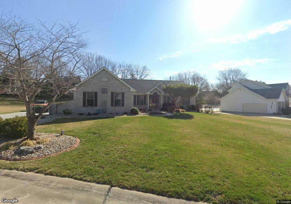
5531 Hennsley Cir Weldon Spring, MO 63304
Estimated Value: $573,170 - $705,000
3
Beds
2
Baths
2,435
Sq Ft
$261/Sq Ft
Est. Value
About This Home
This home is located at 5531 Hennsley Cir, Weldon Spring, MO 63304 and is currently estimated at $636,043, approximately $261 per square foot. 5531 Hennsley Cir is a home located in St. Charles County with nearby schools including Independence Elementary School, Francis Howell Middle School, and Francis Howell Union High School.
Ownership History
Date
Name
Owned For
Owner Type
Purchase Details
Closed on
Dec 19, 2002
Sold by
Bathe Jeffrey E and Bathe Cindy M
Bought by
Haas Edward J and Haas Connie K
Current Estimated Value
Home Financials for this Owner
Home Financials are based on the most recent Mortgage that was taken out on this home.
Original Mortgage
$220,000
Outstanding Balance
$92,595
Interest Rate
5.96%
Estimated Equity
$543,448
Purchase Details
Closed on
Jul 9, 1997
Sold by
The Jones Company Custom Homes Inc
Bought by
Bathe Jeffrey E and Bathe Cindy M
Home Financials for this Owner
Home Financials are based on the most recent Mortgage that was taken out on this home.
Original Mortgage
$150,000
Interest Rate
7.5%
Create a Home Valuation Report for This Property
The Home Valuation Report is an in-depth analysis detailing your home's value as well as a comparison with similar homes in the area
Home Values in the Area
Average Home Value in this Area
Purchase History
| Date | Buyer | Sale Price | Title Company |
|---|---|---|---|
| Haas Edward J | $325,000 | -- | |
| Bathe Jeffrey E | -- | -- |
Source: Public Records
Mortgage History
| Date | Status | Borrower | Loan Amount |
|---|---|---|---|
| Open | Haas Edward J | $220,000 | |
| Previous Owner | Bathe Jeffrey E | $150,000 |
Source: Public Records
Tax History Compared to Growth
Tax History
| Year | Tax Paid | Tax Assessment Tax Assessment Total Assessment is a certain percentage of the fair market value that is determined by local assessors to be the total taxable value of land and additions on the property. | Land | Improvement |
|---|---|---|---|---|
| 2025 | $5,344 | $101,535 | -- | -- |
| 2023 | $5,341 | $89,662 | $0 | $0 |
| 2022 | $4,955 | $77,256 | $0 | $0 |
| 2021 | $4,688 | $73,009 | $0 | $0 |
| 2020 | $4,578 | $69,008 | $0 | $0 |
| 2019 | $4,558 | $69,008 | $0 | $0 |
| 2018 | $4,683 | $67,802 | $0 | $0 |
| 2017 | $4,644 | $67,802 | $0 | $0 |
| 2016 | $4,152 | $58,347 | $0 | $0 |
| 2015 | $4,115 | $58,347 | $0 | $0 |
| 2014 | $3,889 | $53,489 | $0 | $0 |
Source: Public Records
Map
Nearby Homes
- 5504 Dressel Dr
- 5576 Wavecrest Cir
- 5701 Wrenwyck Place
- 25 Terre Verte Ct
- 232 Maple Point Dr
- 5579 Westerfield Pkwy Unit 8B
- 14 Walnut Hill Ct
- 831 Ridgetop Cir
- 0 Universal Design Prairie Bluff Unit MAR24041208
- 1209 Crooked Creek Dr
- 1361 Briar Creek Dr
- 301 Switchgrass Landing Ln
- Rosemont Plan at Prairie Bluff - Heritage Collection
- Sierra Plan at Prairie Bluff - Heritage Collection
- Sierra – Universal Design Plan at Prairie Bluff - Heritage Collection
- Pierce Plan at Prairie Bluff - Heritage Collection
- Lancaster Plan at Prairie Bluff - Heritage Collection
- Chesapeake Plan at Prairie Bluff - Heritage Collection
- Windsor Plan at Prairie Bluff - Heritage Collection
- Bridgeport Plan at Prairie Bluff - Heritage Collection
- 5535 Hennsley Cir
- 5529 Hennsley Cir
- 932 Arbor Green Dr
- 936 Arbor Green Dr
- 5539 Hennsley Cir
- 5532 Hennsley Cir
- 5527 Hennsley Cir
- 928 Arbor Green Dr
- 940 Arbor Green Dr
- 5525 Hennsley Cir
- 5538 Hennsley Cir
- 5543 Hennsley Cir
- 924 Arbor Green Dr
- 5552 Ashboro Dr
- 5550 Ashboro Dr
- 5524 Hennsley Cir
- 5554 Ashboro Dr
- 927 Arbor Green Dr
- 5556 Ashboro Dr
- 944 Arbor Green Dr