5532 Carley Ave Whittier, CA 90601
West Whittier NeighborhoodEstimated Value: $671,000 - $752,000
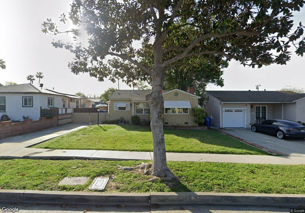
About This Home
This home is located at 5532 Carley Ave, Whittier, CA 90601 and is currently estimated at $712,891, approximately $764 per square foot. 5532 Carley Ave is a home located in Los Angeles County with nearby schools including Orange Grove Elementary School, Walter F. Dexter Middle School, and Whittier High School.
Ownership History
We collect this data history from publicly available records. To have your information removed, we recommend requesting removal directly through your county’s website.
Purchase Details
Purchase Details
Home Financials for this Owner
Home Financials are based on the most recent Mortgage that was taken out on this home.Home Values in the Area
Average Home Value in this Area
Purchase History
We collect this data history from publicly available records. To have your information removed, we recommend requesting removal directly through your county’s website.
| Date | Buyer | Sale Price | Title Company |
|---|---|---|---|
| -- | -- | ||
| $117,000 | Continental Lawyers Title Co |
Mortgage History
We collect this data history from publicly available records. To have your information removed, we recommend requesting removal directly through your county’s website.
| Date | Status | Borrower | Loan Amount |
|---|---|---|---|
| Closed | $112,000 |
Tax History
We collect this data history from publicly available records. To have your information removed, we recommend requesting removal directly through your county’s website.
| Year | Tax Paid | Tax Assessment Tax Assessment Total Assessment is a certain percentage of the fair market value that is determined by local assessors to be the total taxable value of land and additions on the property. | Land | Improvement |
|---|---|---|---|---|
| 2025 | $2,953 | $194,814 | $157,036 | $37,778 |
| 2024 | $2,710 | $190,995 | $153,957 | $37,038 |
| 2023 | $2,697 | $187,251 | $150,939 | $36,312 |
| 2022 | $2,763 | $183,580 | $147,980 | $35,600 |
| 2021 | $2,711 | $179,981 | $145,079 | $34,902 |
| 2019 | $2,682 | $174,645 | $140,777 | $33,868 |
| 2018 | $2,481 | $171,221 | $138,017 | $33,204 |
| 2016 | $2,415 | $164,573 | $132,658 | $31,915 |
| 2015 | $2,462 | $162,102 | $130,666 | $31,436 |
| 2014 | $2,311 | $158,928 | $128,107 | $30,821 |
Map
- 10602 Monaco Ct
- 5593 Pioneer Blvd Unit 18
- 5593 Pioneer Blvd
- 5519 Pioneer Blvd Unit 42
- 5411 Cadbury Rd
- 5903 Redman Ave
- 5456 Cadbury Rd
- 5814 Juarez Ave
- 5729 Juarez Ave
- 11045 Howard St
- 10608 Whittier Blvd
- 11837 Rideout Way
- 10853 Glencannon Dr
- 6217 Norwalk Blvd
- 6233 Vicki Dr
- 4918 Tobias Ave Unit 6
- 3832 Abbeywood Ave
- 10919 Loch Lomond Dr
- 9530 Underwood St
- 9367 Via Azul
- 5528 Carley Ave
- 5538 Carley Ave
- 5522 Carley Ave
- 5542 Carley Ave
- 5533 Mavis Ave
- 5527 Mavis Ave
- 5537 Mavis Ave
- 5518 Carley Ave
- 5523 Mavis Ave
- 5543 Mavis Ave
- 5533 Carley Ave
- 5527 Carley Ave
- 5537 Carley Ave
- 5512 Carley Ave
- 5552 Carley Ave
- 5517 Mavis Ave
- 5547 Mavis Ave
- 5543 Carley Ave
- 5523 Carley Ave
- 5513 Mavis Ave
Ask me questions while you tour the home.