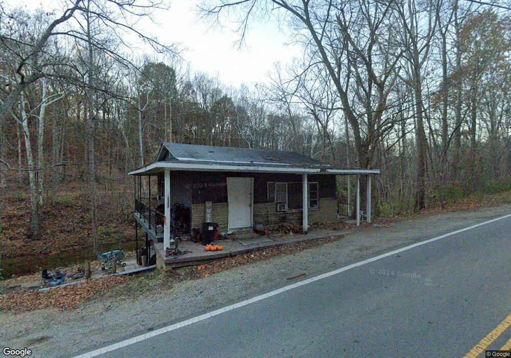
5535 State Route 41 N Bainbridge, OH 45612
Estimated Value: $85,754 - $133,000
--
Bed
2
Baths
612
Sq Ft
$179/Sq Ft
Est. Value
About This Home
This home is located at 5535 State Route 41 N, Bainbridge, OH 45612 and is currently estimated at $109,439, approximately $178 per square foot. 5535 State Route 41 N is a home located in Ross County with nearby schools including Paint Valley Elementary School, Paint Valley Middle School, and Paint Valley High School.
Ownership History
Date
Name
Owned For
Owner Type
Purchase Details
Closed on
Nov 4, 2014
Sold by
Estate Of Selma Q Frey
Bought by
Griffith Forrest and Griffith Larry J
Current Estimated Value
Purchase Details
Closed on
May 20, 2011
Sold by
Estate Of Edgar Donald Wilson
Bought by
Wilson Mark Douglas
Purchase Details
Closed on
May 10, 2011
Sold by
Wilson Mark Douglas
Bought by
Wilson Mark Douglas
Create a Home Valuation Report for This Property
The Home Valuation Report is an in-depth analysis detailing your home's value as well as a comparison with similar homes in the area
Home Values in the Area
Average Home Value in this Area
Purchase History
| Date | Buyer | Sale Price | Title Company |
|---|---|---|---|
| Griffith Forrest | -- | Attorney | |
| Wilson Mark Douglas | -- | None Available | |
| Wilson Mark Douglas | -- | Attorney |
Source: Public Records
Tax History Compared to Growth
Tax History
| Year | Tax Paid | Tax Assessment Tax Assessment Total Assessment is a certain percentage of the fair market value that is determined by local assessors to be the total taxable value of land and additions on the property. | Land | Improvement |
|---|---|---|---|---|
| 2024 | $636 | $17,310 | $3,680 | $13,630 |
| 2023 | $636 | $17,310 | $3,680 | $13,630 |
| 2022 | $640 | $17,310 | $3,680 | $13,630 |
| 2021 | $631 | $15,830 | $3,260 | $12,570 |
| 2020 | $631 | $15,830 | $3,260 | $12,570 |
| 2019 | $642 | $15,830 | $3,260 | $12,570 |
| 2018 | $576 | $13,740 | $2,730 | $11,010 |
| 2017 | $577 | $13,740 | $2,730 | $11,010 |
| 2016 | $564 | $13,740 | $2,730 | $11,010 |
| 2015 | $516 | $12,830 | $2,730 | $10,100 |
| 2014 | $489 | $12,830 | $2,730 | $10,100 |
| 2013 | $741 | $19,140 | $2,730 | $16,410 |
Source: Public Records
Map
Nearby Homes
- 213 S Benner Hill Rd
- 1540 Cove Run Rd
- 301 N Maple St
- 201 N Maple St
- 2470 Tong Hollow Rd
- 316 S Maple St
- 2780 Potts Hill Rd
- 2780 Potts Hill Rd Unit (Tract 4 at Potts Hi
- 0 Upper Twin Rd Unit 5159777
- 0 Upper Twin Rd Unit 225036418
- 4945 Upper Twin Rd
- 0 Schmidt Rd
- 7724 Cave Rd
- 948 Mount Olive Rd
- 948 Mt Olive Rd
- 7885 Upper Twin Rd
- 4511 Potts Hill
- 4511 Potts Hill Rd
- 14703 Brier Rd
- 0 Potts Hill Rd Unit 225030231
- 5538 State Route 41 N
- 5238 State Route 41 N
- 5238 State Route 41 N
- 5215 State Route 41 N
- 5190 State Route 41 N
- 5178 State Route 41 N
- 841 N Benner Hill Rd
- 139 Whetstone Rd
- 5155 State Route 41 N
- 916 N Benner Hill Rd
- 5156 State Route 41 N
- 5156 State Route 41 N
- 149 Whetstone Rd
- 5108 State Route 41 N
- 916 N Benner Hill Rd
- 219 Whetstone Rd
- 942 N Benner Hill Rd
- 5078 State Route 41 N
- 6028 State Route 41 N
- 228 Whetstone Rd