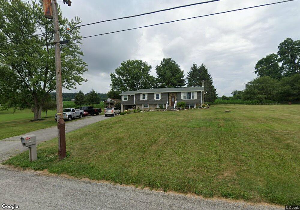
5538 Stormy Hill Rd Spring Grove, PA 17362
Estimated Value: $324,741 - $486,000
3
Beds
2
Baths
2,977
Sq Ft
$134/Sq Ft
Est. Value
About This Home
This home is located at 5538 Stormy Hill Rd, Spring Grove, PA 17362 and is currently estimated at $398,685, approximately $133 per square foot. 5538 Stormy Hill Rd is a home located in York County with nearby schools including Spring Grove Area Middle School, Spring Grove Area High School, and Garbers Mennonite School.
Ownership History
Date
Name
Owned For
Owner Type
Purchase Details
Closed on
Sep 28, 2007
Sold by
Hartman Clifford B
Bought by
Pierce Daniel B and Pierce Denise E
Current Estimated Value
Home Financials for this Owner
Home Financials are based on the most recent Mortgage that was taken out on this home.
Original Mortgage
$220,250
Outstanding Balance
$140,652
Interest Rate
6.65%
Mortgage Type
Purchase Money Mortgage
Estimated Equity
$258,033
Create a Home Valuation Report for This Property
The Home Valuation Report is an in-depth analysis detailing your home's value as well as a comparison with similar homes in the area
Home Values in the Area
Average Home Value in this Area
Purchase History
| Date | Buyer | Sale Price | Title Company |
|---|---|---|---|
| Pierce Daniel B | $225,000 | None Available |
Source: Public Records
Mortgage History
| Date | Status | Borrower | Loan Amount |
|---|---|---|---|
| Open | Pierce Daniel B | $220,250 |
Source: Public Records
Tax History Compared to Growth
Tax History
| Year | Tax Paid | Tax Assessment Tax Assessment Total Assessment is a certain percentage of the fair market value that is determined by local assessors to be the total taxable value of land and additions on the property. | Land | Improvement |
|---|---|---|---|---|
| 2025 | $5,377 | $161,210 | $38,000 | $123,210 |
| 2024 | $5,319 | $161,210 | $38,000 | $123,210 |
| 2023 | $5,319 | $161,210 | $38,000 | $123,210 |
| 2022 | $5,319 | $161,210 | $38,000 | $123,210 |
| 2021 | $5,089 | $161,210 | $38,000 | $123,210 |
| 2020 | $5,089 | $161,210 | $38,000 | $123,210 |
| 2019 | $5,052 | $161,210 | $38,000 | $123,210 |
| 2018 | $4,986 | $161,210 | $38,000 | $123,210 |
| 2017 | $4,872 | $161,210 | $38,000 | $123,210 |
| 2016 | $0 | $161,210 | $38,000 | $123,210 |
| 2015 | -- | $161,210 | $38,000 | $123,210 |
| 2014 | -- | $161,210 | $38,000 | $123,210 |
Source: Public Records
Map
Nearby Homes
- 5497 Stambaugh Rd
- 1709 Jefferson Rd
- 1495 Jefferson Rd
- Lot # 2 Midhill Rd
- Lot # 1 Midhill Rd
- Lot# 3 Midhill Rd
- 5931 York Rd
- 2405 Myers Rd
- 6306 Liam Dr
- 6319 Liam Dr
- 6309 Liam Dr
- 6325 Liam Dr
- 6313 Liam Dr
- 6324 Liam
- 6314 Liam Dr
- 0 Sassafras Plan at Hills at Valley View Unit PAYK2082018
- 0 Pin Oak 5br Plan at Hills at Valley View Unit PAYK2087614
- 0 Sugar Maple Plan at Hills at Valley View Unit PAYK2082020
- 1063 Porters Rd
- 0 White Oak Plan at Hills at Valley View Unit PAYK2082080
- 5520 Stormy Hill Rd
- 1764 Dubbs Rd
- 5492 Thoman Dr
- 5589 Stormy Hill Rd
- 1769 Dubbs Rd
- 5597 Stormy Hill Rd
- 5545 Thoman Dr
- 4315 Brent Dr
- 4313 Brent Dr
- 4309 Brent Dr
- 4311 Brent Dr
- 4317 Brent Dr
- 4319 Brent Dr
- 5632 Thoman Dr
- 5626 Thoman Dr
- 5614 Thoman Dr
- 5564 Thoman Dr
- 5596 Thoman Dr
- 5638 Thoman Dr
- 5555 Thoman Dr