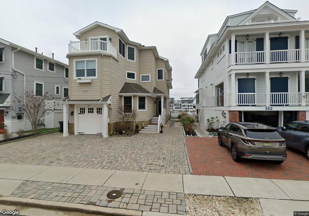
554 22nd St Avalon, NJ 08202
Estimated Value: $3,974,678 - $4,781,000
6
Beds
4
Baths
3,659
Sq Ft
$1,209/Sq Ft
Est. Value
About This Home
This home is located at 554 22nd St, Avalon, NJ 08202 and is currently estimated at $4,423,920, approximately $1,209 per square foot. 554 22nd St is a home located in Cape May County with nearby schools including Avalon Elementary School.
Ownership History
Date
Name
Owned For
Owner Type
Purchase Details
Closed on
May 2, 2025
Sold by
Richard A Schnabel Revocable Living Trus and Lee A Tierney Revocable Living Trust
Bought by
Demaria Richard A
Current Estimated Value
Home Financials for this Owner
Home Financials are based on the most recent Mortgage that was taken out on this home.
Original Mortgage
$2,850,000
Outstanding Balance
$2,810,139
Interest Rate
5.89%
Mortgage Type
New Conventional
Estimated Equity
$1,613,781
Purchase Details
Closed on
Mar 5, 2021
Sold by
Schnabel Richard and Tierney Lee
Bought by
Richard A Schnabel Ret
Purchase Details
Closed on
May 25, 2000
Purchase Details
Closed on
May 7, 1999
Sold by
168 Commercial Corporation
Bought by
Avalon Enterprises
Home Financials for this Owner
Home Financials are based on the most recent Mortgage that was taken out on this home.
Original Mortgage
$527,250
Interest Rate
6.92%
Create a Home Valuation Report for This Property
The Home Valuation Report is an in-depth analysis detailing your home's value as well as a comparison with similar homes in the area
Home Values in the Area
Average Home Value in this Area
Purchase History
| Date | Buyer | Sale Price | Title Company |
|---|---|---|---|
| Demaria Richard A | $4,125,000 | Foundation Title | |
| Richard A Schnabel Ret | -- | None Available | |
| Lee A Tierney Revocable Living Trust | -- | None Listed On Document | |
| -- | $742,000 | -- | |
| Avalon Enterprises | $525,000 | -- | |
| 168 Commercial Corporation | $340,000 | -- |
Source: Public Records
Mortgage History
| Date | Status | Borrower | Loan Amount |
|---|---|---|---|
| Open | Demaria Richard A | $2,850,000 | |
| Previous Owner | 168 Commercial Corporation | $527,250 |
Source: Public Records
Tax History
| Year | Tax Paid | Tax Assessment Tax Assessment Total Assessment is a certain percentage of the fair market value that is determined by local assessors to be the total taxable value of land and additions on the property. | Land | Improvement |
|---|---|---|---|---|
| 2025 | $11,324 | $1,844,300 | $1,200,000 | $644,300 |
| 2024 | $11,324 | $1,844,300 | $1,200,000 | $644,300 |
| 2023 | $11,232 | $1,844,300 | $1,200,000 | $644,300 |
| 2022 | $10,476 | $1,844,300 | $1,200,000 | $644,300 |
| 2021 | $10,088 | $1,844,300 | $1,200,000 | $644,300 |
| 2020 | $9,701 | $1,844,300 | $1,200,000 | $644,300 |
| 2019 | $9,406 | $1,844,300 | $1,200,000 | $644,300 |
| 2018 | $9,000 | $1,844,300 | $1,200,000 | $644,300 |
| 2017 | $10,136 | $1,823,100 | $1,230,000 | $593,100 |
| 2016 | $10,027 | $1,823,100 | $1,230,000 | $593,100 |
| 2015 | $9,863 | $1,823,100 | $1,230,000 | $593,100 |
| 2014 | $9,754 | $1,823,100 | $1,230,000 | $593,100 |
Source: Public Records
Map
Nearby Homes
- 447 24th St
- 890 21st St
- 389 22nd St
- 415 20th St
- 386 24th St
- 386 24th St Unit Upper
- 2425 Harbor Ave Unit 2425
- 1668 Ocean Dr Unit B1
- 211 23rd St
- 212 25th St Unit End Unit
- 16 4th Ave
- 2928 Ocean Dr Unit C-N
- 2934 Ocean Dr Unit North
- 2023 Dune Dr Unit R6
- 174 23rd St
- 178 19th St
- 179 27th St
- 118 22nd St
- 285 14th St Unit 285
- 285 14th St
Your Personal Tour Guide
Ask me questions while you tour the home.