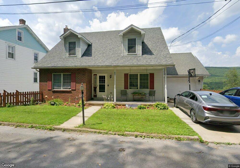
554 E Railroad St Nesquehoning, PA 18240
Estimated Value: $178,000 - $200,000
3
Beds
3
Baths
1,669
Sq Ft
$113/Sq Ft
Est. Value
About This Home
This home is located at 554 E Railroad St, Nesquehoning, PA 18240 and is currently estimated at $189,292, approximately $113 per square foot. 554 E Railroad St is a home located in Carbon County with nearby schools including Panther Valley Elementary School, Panther Valley Intermediate School, and Panther Valley Junior/Senior High School.
Ownership History
Date
Name
Owned For
Owner Type
Purchase Details
Closed on
Sep 9, 2008
Sold by
Lasalle Bank Na
Bought by
Weng David M and Weng Sherry L
Current Estimated Value
Home Financials for this Owner
Home Financials are based on the most recent Mortgage that was taken out on this home.
Original Mortgage
$76,000
Outstanding Balance
$50,332
Interest Rate
6.43%
Mortgage Type
New Conventional
Estimated Equity
$138,960
Purchase Details
Closed on
May 30, 2008
Sold by
Boggs Kenneth P
Bought by
Lasalle Bank
Create a Home Valuation Report for This Property
The Home Valuation Report is an in-depth analysis detailing your home's value as well as a comparison with similar homes in the area
Home Values in the Area
Average Home Value in this Area
Purchase History
| Date | Buyer | Sale Price | Title Company |
|---|---|---|---|
| Weng David M | $95,000 | None Available | |
| Lasalle Bank | $2,095 | None Available |
Source: Public Records
Mortgage History
| Date | Status | Borrower | Loan Amount |
|---|---|---|---|
| Open | Weng David M | $76,000 |
Source: Public Records
Tax History
| Year | Tax Paid | Tax Assessment Tax Assessment Total Assessment is a certain percentage of the fair market value that is determined by local assessors to be the total taxable value of land and additions on the property. | Land | Improvement |
|---|---|---|---|---|
| 2025 | $2,864 | $30,313 | $4,250 | $26,063 |
| 2024 | $2,981 | $30,313 | $4,250 | $26,063 |
| 2023 | $2,921 | $30,313 | $4,250 | $26,063 |
| 2022 | $2,940 | $30,313 | $4,250 | $26,063 |
| 2021 | $2,940 | $30,313 | $4,250 | $26,063 |
| 2020 | $2,895 | $30,313 | $4,250 | $26,063 |
| 2019 | $2,728 | $30,313 | $4,250 | $26,063 |
| 2018 | $2,698 | $30,313 | $4,250 | $26,063 |
| 2017 | $2,698 | $30,313 | $4,250 | $26,063 |
| 2016 | -- | $30,313 | $4,250 | $26,063 |
| 2015 | -- | $30,313 | $4,250 | $26,063 |
| 2014 | -- | $30,313 | $4,250 | $26,063 |
Source: Public Records
Map
Nearby Homes
- 255 E Railroad St
- 106 E Catawissa St
- 68 E Railroad St
- 1165 E Catawissa St
- 2 W Catawissa St
- 50 W Catawissa St
- 12 Coal St
- 0 W High St
- 134 W Railroad St Unit 136
- 153 W High St
- 58 W Columbus Ave
- 129 Lentz Trail
- 54 Coal St
- 401 Highland Hill Rd
- 3 1st Ave
- A591 Apple Lane & Stony Mountain
- 644 Center Ave
- 622 Center Ave
- 419 E White Bear Dr
- 532 South Ave
- 544 E Railroad St
- 564 E Railroad St
- 566 E Railroad St
- 116 Spruce St
- 539 E Center St
- 521 E Railroad St
- 571 E Center St
- 535 E Center St
- 531 E Center St
- 600 E Railroad St
- 518 E Railroad St
- 527 E Center St
- 511 E Railroad St
- 115 Spruce St
- 521 E Center St
- 601 E Center St
- 514 E Railroad St
- 580 E Center St
- 513 E Center St
- 610 E Railroad St
Your Personal Tour Guide
Ask me questions while you tour the home.