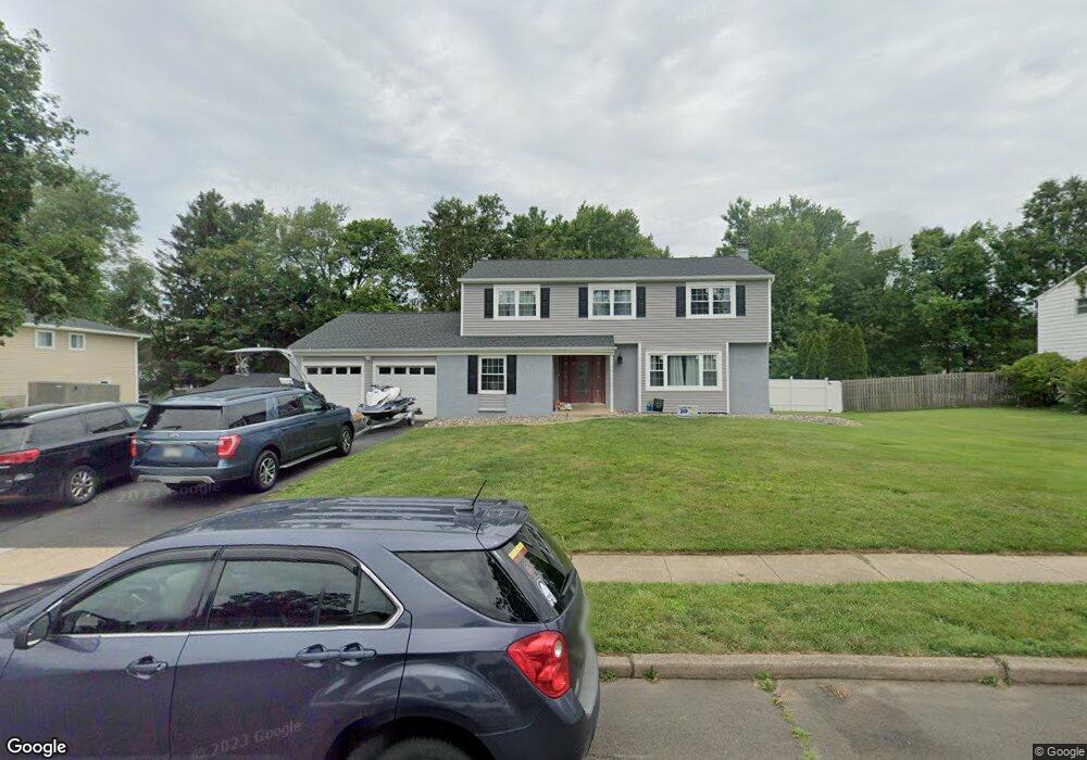
554 Hammond Dr Yardley, PA 19067
Estimated Value: $609,337 - $740,000
4
Beds
3
Baths
2,329
Sq Ft
$281/Sq Ft
Est. Value
About This Home
This home is located at 554 Hammond Dr, Yardley, PA 19067 and is currently estimated at $655,084, approximately $281 per square foot. 554 Hammond Dr is a home located in Bucks County with nearby schools including Eleanor Roosevelt Elementary School, Pennwood Middle School, and Pennsbury High School.
Ownership History
Date
Name
Owned For
Owner Type
Purchase Details
Closed on
Nov 26, 2007
Sold by
Curry Robert and Curry Julie
Bought by
Peterson David John and Peterson Jeanette Marie
Current Estimated Value
Home Financials for this Owner
Home Financials are based on the most recent Mortgage that was taken out on this home.
Original Mortgage
$324,000
Outstanding Balance
$205,079
Interest Rate
6.3%
Mortgage Type
Negative Amortization
Estimated Equity
$450,005
Purchase Details
Closed on
Apr 12, 2002
Sold by
Conroy Gerald C and Conroy Sally
Bought by
Curry Robert and Curry Julie
Home Financials for this Owner
Home Financials are based on the most recent Mortgage that was taken out on this home.
Original Mortgage
$225,250
Interest Rate
6.85%
Create a Home Valuation Report for This Property
The Home Valuation Report is an in-depth analysis detailing your home's value as well as a comparison with similar homes in the area
Home Values in the Area
Average Home Value in this Area
Purchase History
| Date | Buyer | Sale Price | Title Company |
|---|---|---|---|
| Peterson David John | $405,000 | None Available | |
| Curry Robert | $265,000 | -- |
Source: Public Records
Mortgage History
| Date | Status | Borrower | Loan Amount |
|---|---|---|---|
| Open | Peterson David John | $324,000 | |
| Previous Owner | Curry Robert | $225,250 | |
| Closed | Curry Robert | $30,000 |
Source: Public Records
Tax History
| Year | Tax Paid | Tax Assessment Tax Assessment Total Assessment is a certain percentage of the fair market value that is determined by local assessors to be the total taxable value of land and additions on the property. | Land | Improvement |
|---|---|---|---|---|
| 2025 | $8,430 | $35,600 | $7,720 | $27,880 |
| 2024 | $8,430 | $35,600 | $7,720 | $27,880 |
| 2023 | $8,007 | $35,600 | $7,720 | $27,880 |
| 2022 | $7,833 | $35,600 | $7,720 | $27,880 |
| 2021 | $7,709 | $35,600 | $7,720 | $27,880 |
| 2020 | $7,709 | $35,600 | $7,720 | $27,880 |
| 2019 | $7,556 | $35,600 | $7,720 | $27,880 |
| 2018 | $7,423 | $35,600 | $7,720 | $27,880 |
| 2017 | $7,194 | $35,600 | $7,720 | $27,880 |
| 2016 | $7,110 | $35,600 | $7,720 | $27,880 |
| 2015 | -- | $35,600 | $7,720 | $27,880 |
| 2014 | -- | $35,600 | $7,720 | $27,880 |
Source: Public Records
Map
Nearby Homes
- 224 Marlboro Rd
- 329 Sherwood Dr
- 65 Sutphin Pines
- 58 Sutphin Pnes Pines
- 50 Sutphin Rd
- 115 Winding Way
- 108 Glen Valley Rd
- 581 Rosemar Dr
- 508 Carmela Way
- 1802 Yardley Morrisville Rd
- 1016 Evergreen Rd
- 10 Makefield Rd
- 11 Carolina Ave
- 0 Walnut Ln
- 101 Walnut Ln
- LOT 021-003 W M Y Ln
- 708 Barclay Ave
- 105 Vernon Ln
- 333 E Birch Dr
- 625 Hillcrest Ave
Your Personal Tour Guide
Ask me questions while you tour the home.