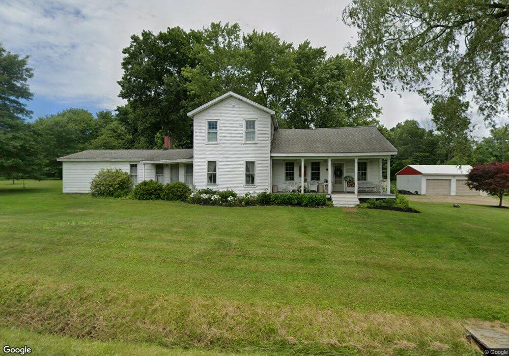
5540 Gibson Hill Rd Edinboro, PA 16412
Estimated Value: $237,000 - $393,000
6
Beds
3
Baths
2,528
Sq Ft
$126/Sq Ft
Est. Value
About This Home
This home is located at 5540 Gibson Hill Rd, Edinboro, PA 16412 and is currently estimated at $317,702, approximately $125 per square foot. 5540 Gibson Hill Rd is a home located in Erie County with nearby schools including Edinboro Elementary School, James W. Parker Middle School, and General McLane High School.
Ownership History
Date
Name
Owned For
Owner Type
Purchase Details
Closed on
Sep 16, 2025
Sold by
Brokman Neal A
Bought by
Brokman Megan S
Current Estimated Value
Purchase Details
Closed on
Jul 9, 2009
Sold by
Tillman Mary Ann and Tillman Thomas
Bought by
Brokman Neal A and Brokman Megan S
Home Financials for this Owner
Home Financials are based on the most recent Mortgage that was taken out on this home.
Original Mortgage
$75,600
Interest Rate
5.31%
Mortgage Type
Purchase Money Mortgage
Create a Home Valuation Report for This Property
The Home Valuation Report is an in-depth analysis detailing your home's value as well as a comparison with similar homes in the area
Home Values in the Area
Average Home Value in this Area
Purchase History
| Date | Buyer | Sale Price | Title Company |
|---|---|---|---|
| Brokman Megan S | -- | None Listed On Document | |
| Brokman Neal A | $94,500 | None Available |
Source: Public Records
Mortgage History
| Date | Status | Borrower | Loan Amount |
|---|---|---|---|
| Previous Owner | Brokman Neal A | $75,600 |
Source: Public Records
Tax History Compared to Growth
Tax History
| Year | Tax Paid | Tax Assessment Tax Assessment Total Assessment is a certain percentage of the fair market value that is determined by local assessors to be the total taxable value of land and additions on the property. | Land | Improvement |
|---|---|---|---|---|
| 2025 | $2,196 | $96,220 | $46,800 | $49,420 |
| 2024 | $2,126 | $96,220 | $46,800 | $49,420 |
| 2023 | $2,001 | $96,220 | $46,800 | $49,420 |
| 2022 | $1,944 | $96,220 | $46,800 | $49,420 |
| 2021 | $1,919 | $96,220 | $46,800 | $49,420 |
| 2020 | $1,895 | $96,220 | $46,800 | $49,420 |
| 2019 | $1,882 | $96,220 | $46,800 | $49,420 |
| 2018 | $1,842 | $96,220 | $46,800 | $49,420 |
| 2017 | $1,842 | $96,220 | $46,800 | $49,420 |
| 2016 | $2,271 | $96,220 | $46,800 | $49,420 |
| 2015 | $2,247 | $96,220 | $46,800 | $49,420 |
| 2014 | $1,045 | $96,220 | $46,800 | $49,420 |
Source: Public Records
Map
Nearby Homes
- 13194 Capp Rd
- 12851 Fry Rd
- 0 Gibson Hill #14 Rd
- 5241 Tarbell Rd
- 0 Sherrod Hill #13 Rd
- 0 Sherrod Hill #15 Rd
- 101 Beau Dr
- 203 N Skytop Rd
- 125 Hilltop Rd
- 12356 Culbertson Dr
- 122 Water St
- 5453 Woodlawn Dr
- 411 W Plum St
- 401 W Plum St
- 0 6n Route Unit 187309
- 0 Ymca Dr
- 0 Beach Ave Extension Unit 1682668
- 122 Terrace Dr
- 142 Meadville St
- 111 Washington St
- 5520 Gibson Hill Rd
- 5580 Gibson Hill Rd
- 5526 Gibson Hill Rd
- 5211 Sherrod Hill Rd
- 5600 Gibson Hill Rd
- 5630 Gibson Hill Rd
- 5641 Gibson Hill Rd
- 5640 Gibson Hill Rd
- 1754 Timber Creek Ln
- 1820 Timber Creek Ln
- 5650 Gibson Hill Rd
- 5671 Sherrod Hill Rd
- 12791 Fry Rd
- 12811 Fry Rd
- 5341 Gibson Hill Rd
- 5611 Sherrod Hill Rd
- 5501 Sherrod Hill Rd
- 5591 Sherrod Hill Rd
- 12741 Fry Rd
- 12921 Fry Rd