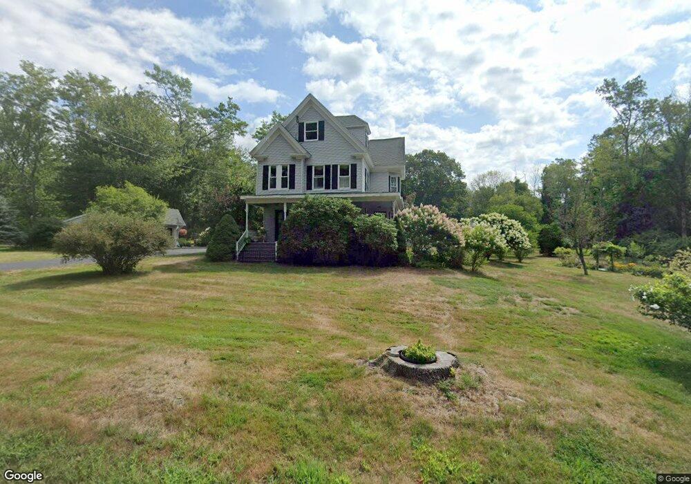
555 Haley Rd Kittery Point, ME 03905
Kittery Point NeighborhoodEstimated Value: $646,000 - $749,000
4
Beds
2
Baths
1,824
Sq Ft
$375/Sq Ft
Est. Value
About This Home
This home is located at 555 Haley Rd, Kittery Point, ME 03905 and is currently estimated at $684,123, approximately $375 per square foot. 555 Haley Rd is a home located in York County with nearby schools including Horace Mitchell Primary School, Shapleigh School, and Robert W Traip Academy.
Ownership History
Date
Name
Owned For
Owner Type
Purchase Details
Closed on
Oct 27, 2006
Sold by
Maine Coast Invest Llc
Bought by
Wotton Elaine M and Wotton Clinton G
Current Estimated Value
Create a Home Valuation Report for This Property
The Home Valuation Report is an in-depth analysis detailing your home's value as well as a comparison with similar homes in the area
Home Values in the Area
Average Home Value in this Area
Purchase History
| Date | Buyer | Sale Price | Title Company |
|---|---|---|---|
| Wotton Elaine M | -- | -- |
Source: Public Records
Tax History
| Year | Tax Paid | Tax Assessment Tax Assessment Total Assessment is a certain percentage of the fair market value that is determined by local assessors to be the total taxable value of land and additions on the property. | Land | Improvement |
|---|---|---|---|---|
| 2024 | $4,998 | $352,000 | $112,200 | $239,800 |
| 2023 | $4,791 | $352,000 | $112,200 | $239,800 |
| 2022 | $4,745 | $352,000 | $112,200 | $239,800 |
| 2021 | $4,576 | $352,000 | $112,200 | $239,800 |
| 2020 | $4,541 | $352,000 | $112,200 | $239,800 |
| 2019 | $4,145 | $238,200 | $71,500 | $166,700 |
| 2018 | $4,002 | $238,200 | $71,500 | $166,700 |
| 2017 | $3,930 | $238,200 | $71,500 | $166,700 |
| 2016 | $3,823 | $238,200 | $71,500 | $166,700 |
| 2015 | $3,733 | $238,200 | $71,500 | $166,700 |
| 2014 | $3,697 | $238,200 | $71,500 | $166,700 |
| 2013 | $3,625 | $238,200 | $71,500 | $166,700 |
Source: Public Records
Map
Nearby Homes
- 25 Bartlett Rd
- 12 Gillis Dr Unit 3
- 8 Spruce Point Rd
- 24 Seabreeze Ln
- 13 Cross St
- 7 Washburn Farm Ln Unit 9
- 2 Washburn Farm Ln Unit 1
- 18 Washburn Farm Ln Unit 4
- 175 Wentworth Rd
- 4 Trefethen Ave
- 12 Washburn Farm Ln Unit 3
- 3 Izzy Ln
- 18 Mainmast Cir
- 30 Drake Ln
- 50 Lewis Rd
- 17 Lavenger Ln
- 13 Washburn Farm Ln Unit 7
- 100 Shepard's Cove Rd Unit F204
- 100 Shepard's Cove Rd Unit G107
- 100 Shepards Cove Rd Unit F204
Your Personal Tour Guide
Ask me questions while you tour the home.