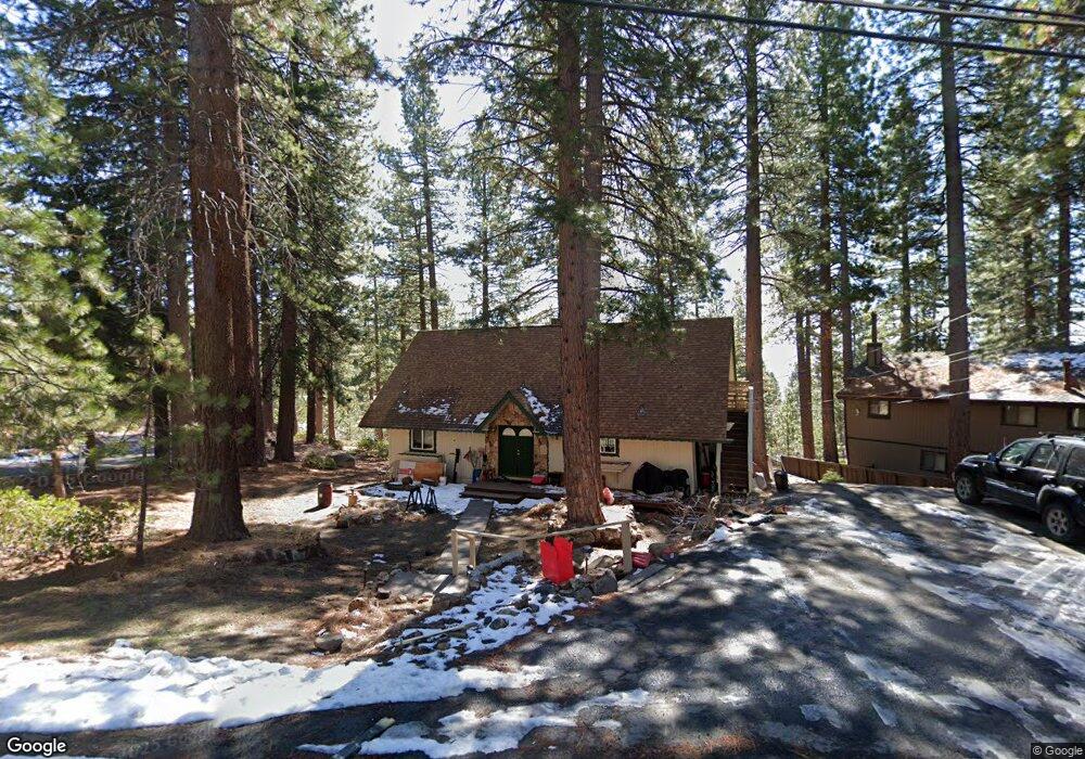
555 Pinion Dr Incline Village, NV 89451
Estimated Value: $1,398,470 - $2,734,000
4
Beds
2
Baths
1,770
Sq Ft
$1,105/Sq Ft
Est. Value
About This Home
This home is located at 555 Pinion Dr, Incline Village, NV 89451 and is currently estimated at $1,955,368, approximately $1,104 per square foot. 555 Pinion Dr is a home located in Washoe County with nearby schools including Incline Elementary School, Incline Middle School, and Incline High School.
Ownership History
Date
Name
Owned For
Owner Type
Purchase Details
Closed on
Nov 14, 2022
Sold by
Hutzky Paul E
Bought by
Paul E Hutzky Living Trust
Current Estimated Value
Purchase Details
Closed on
Jul 20, 2015
Sold by
Hutzky Janice
Bought by
Hutzky Paul
Purchase Details
Closed on
May 4, 1994
Sold by
Reid Elba E
Bought by
Hutzky Paul E and Hutzky Janice A
Home Financials for this Owner
Home Financials are based on the most recent Mortgage that was taken out on this home.
Original Mortgage
$135,000
Interest Rate
8.1%
Create a Home Valuation Report for This Property
The Home Valuation Report is an in-depth analysis detailing your home's value as well as a comparison with similar homes in the area
Home Values in the Area
Average Home Value in this Area
Purchase History
| Date | Buyer | Sale Price | Title Company |
|---|---|---|---|
| Paul E Hutzky Living Trust | -- | -- | |
| Hutzky Paul | -- | None Available | |
| Hutzky Paul E | $240,000 | First Centennial Title Co |
Source: Public Records
Mortgage History
| Date | Status | Borrower | Loan Amount |
|---|---|---|---|
| Previous Owner | Hutzky Paul E | $135,000 | |
| Closed | Hutzky Paul E | $25,000 |
Source: Public Records
Tax History Compared to Growth
Tax History
| Year | Tax Paid | Tax Assessment Tax Assessment Total Assessment is a certain percentage of the fair market value that is determined by local assessors to be the total taxable value of land and additions on the property. | Land | Improvement |
|---|---|---|---|---|
| 2025 | $7,920 | $273,634 | $241,500 | $32,134 |
| 2024 | $7,372 | $252,174 | $220,500 | $31,674 |
| 2023 | $7,372 | $228,854 | $199,500 | $29,354 |
| 2022 | $7,185 | $193,451 | $168,000 | $25,451 |
| 2021 | $6,711 | $175,700 | $151,200 | $24,500 |
| 2020 | $6,408 | $166,492 | $142,800 | $23,692 |
| 2019 | $6,142 | $156,793 | $134,400 | $22,393 |
| 2018 | $5,899 | $155,715 | $134,400 | $21,315 |
| 2017 | $5,694 | $146,767 | $126,000 | $20,767 |
| 2016 | $5,571 | $138,348 | $117,600 | $20,748 |
| 2015 | $5,561 | $136,898 | $117,600 | $19,298 |
| 2014 | $5,546 | $136,889 | $117,600 | $19,289 |
| 2013 | -- | $136,120 | $117,600 | $18,520 |
Source: Public Records
Map
Nearby Homes
- 553 Silvertip Dr
- 541 Silvertip Dr
- 563 Knotty Pine Dr
- 527 Sugarpine Dr
- 580 Jackpine Ln
- 573 Knotty Pine Dr
- 607 Crystal Peak Rd
- 539 Cole Cir
- 501 Lakeshore Blvd Unit 30
- 501 Lakeshore Blvd Unit 56
- 581 Tyner Way
- 628 Martis Peak Rd
- 572 Rockrose Ct
- 325 Woodridge Way
- 633 2nd Creek Dr
- 699 Tumbleweed Cir
- 326 Aspen Leaf Ln
- 558 Valley Dr
- 637 Lariat Cir Unit 1
- 608 Tumbleweed Cir
- 553 Pinion Dr
- 557 Pinion Dr
- 549 Ponderosa Ave
- 561 Ponderosa Ave
- 551 Pinion Dr
- 771 Pinion Dr
- 797 Pinion Dr Unit 48
- 547 Ponderosa Ave
- 565 Ponderosa Ave
- 560 Ponderosa Ave
- 545 Ponderosa Ave
- 101 Pinion Dr
- 557 Silvertip Dr
- 564 Ponderosa Ave
- 569 Ponderosa Ave
- 566 Ponderosa Ave
- 551 Silvertip Dr
- 541 Ponderosa Ave
- 547 Silvertip Dr
- 545 Lodgepole Dr