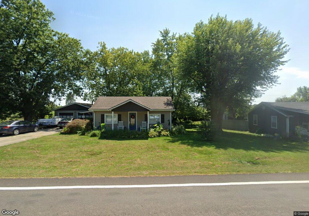
555 State Route 725 W Camden, OH 45311
Estimated Value: $163,739 - $202,000
2
Beds
2
Baths
1,225
Sq Ft
$148/Sq Ft
Est. Value
About This Home
This home is located at 555 State Route 725 W, Camden, OH 45311 and is currently estimated at $181,185, approximately $147 per square foot. 555 State Route 725 W is a home located in Preble County with nearby schools including Preble Shawnee Elementary School, West Elkton Intermediate School, and Preble Shawnee Junior/Senior High School.
Ownership History
Date
Name
Owned For
Owner Type
Purchase Details
Closed on
Feb 16, 1996
Sold by
Davis Calvin W
Bought by
Ronto Richard J and Ronto Annette L
Current Estimated Value
Home Financials for this Owner
Home Financials are based on the most recent Mortgage that was taken out on this home.
Original Mortgage
$54,000
Outstanding Balance
$1,777
Interest Rate
7.07%
Mortgage Type
New Conventional
Estimated Equity
$179,408
Create a Home Valuation Report for This Property
The Home Valuation Report is an in-depth analysis detailing your home's value as well as a comparison with similar homes in the area
Home Values in the Area
Average Home Value in this Area
Purchase History
| Date | Buyer | Sale Price | Title Company |
|---|---|---|---|
| Ronto Richard J | $57,000 | -- |
Source: Public Records
Mortgage History
| Date | Status | Borrower | Loan Amount |
|---|---|---|---|
| Open | Ronto Richard J | $54,000 |
Source: Public Records
Tax History Compared to Growth
Tax History
| Year | Tax Paid | Tax Assessment Tax Assessment Total Assessment is a certain percentage of the fair market value that is determined by local assessors to be the total taxable value of land and additions on the property. | Land | Improvement |
|---|---|---|---|---|
| 2024 | $1,436 | $36,370 | $7,950 | $28,420 |
| 2023 | $1,436 | $36,370 | $7,950 | $28,420 |
| 2022 | $1,320 | $31,750 | $6,340 | $25,410 |
| 2021 | $1,464 | $31,750 | $6,340 | $25,410 |
| 2020 | $1,411 | $31,750 | $6,340 | $25,410 |
| 2019 | $1,284 | $27,620 | $6,130 | $21,490 |
| 2018 | $1,322 | $27,620 | $6,130 | $21,490 |
| 2017 | $1,222 | $27,620 | $6,130 | $21,490 |
| 2016 | $1,220 | $27,090 | $5,950 | $21,140 |
| 2014 | $1,268 | $27,090 | $5,950 | $21,140 |
| 2013 | $1,304 | $27,090 | $5,950 | $21,140 |
Source: Public Records
Map
Nearby Homes
- 407 W Central Ave
- 388 W Hendricks St
- 131 S Lafayette St
- 103 Katherine Ct
- 471 Camden West Elkton Rd
- 725 Sr
- 759 Barnetts Mill Rd
- 679 Oxford Germantown Rd
- 1246 Oxford Germantown Rd
- 1222 Oxford Germantown Rd
- 0 Oxford Germantown Rd
- 314 Lakengren Dr
- 820 Lars Cove
- 817 Old Norse Dr
- 0 Lars Cove Unit 1745954
- 805 Brande Dr
- 250 Lakengren Dr
- 0 Valhalla Cove Unit 941078
- 787 Baltic Dr
- 127 Voyage Dr
- .342 Acres Wagers Dr
- 563 State Route 725 W
- 547 W Central Ave
- 547 State Route 725 W
- 575 State Route 725 W
- 87 Wagers Dr
- 86 Wagers Dr
- 91 Wagers Dr
- 541 State Route 725 W
- 95 Wagers Dr
- 589 State Route 725 W
- 548 State Route 725 W
- 93 Wagers Dr
- 88 Wagers Dr
- 90 Wagers Dr
- 0 Wagers Dr
- 0 Wagers Dr Unit 10034202
- 0 Wagers Dr Unit 1593106
- 542 State Route 725 W
- 92 Wagers Dr