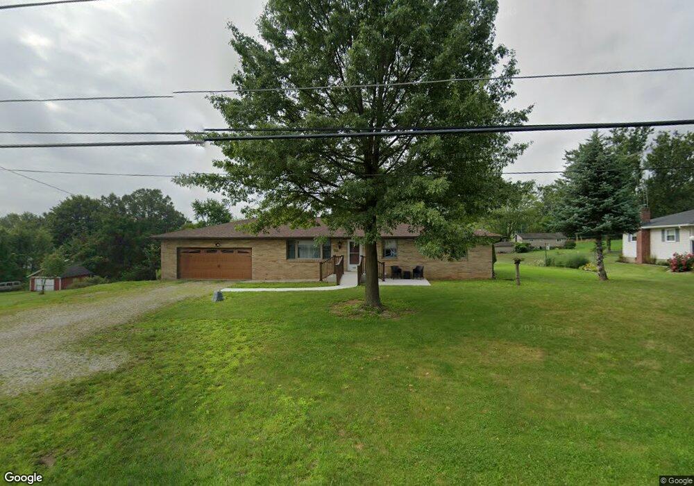
556 53rd St SW Canton, OH 44706
Estimated Value: $191,987 - $358,000
3
Beds
1
Bath
1,344
Sq Ft
$189/Sq Ft
Est. Value
About This Home
This home is located at 556 53rd St SW, Canton, OH 44706 and is currently estimated at $253,997, approximately $188 per square foot. 556 53rd St SW is a home located in Stark County with nearby schools including Faircrest Memorial Elementary School, Canton South High School, and Beacon Academy.
Ownership History
Date
Name
Owned For
Owner Type
Purchase Details
Closed on
Feb 4, 2015
Sold by
Rice Jeri and Fry Jeri
Bought by
Rice Jeri and Rice Kent
Current Estimated Value
Purchase Details
Closed on
Mar 3, 2005
Sold by
Mcgrath Shawn and Mcgrath Brenda C
Bought by
Fry Jeri
Home Financials for this Owner
Home Financials are based on the most recent Mortgage that was taken out on this home.
Original Mortgage
$106,000
Outstanding Balance
$55,544
Interest Rate
6.12%
Mortgage Type
Purchase Money Mortgage
Estimated Equity
$198,453
Create a Home Valuation Report for This Property
The Home Valuation Report is an in-depth analysis detailing your home's value as well as a comparison with similar homes in the area
Purchase History
We collect this data history from publicly available records. To have your information removed, we recommend requesting removal directly through your county’s website.
| Date | Buyer | Sale Price | Title Company |
|---|---|---|---|
| Rice Jeri | -- | None Available | |
| Fry Jeri | $132,500 | -- |
Source: Public Records
Mortgage History
We collect this data history from publicly available records. To have your information removed, we recommend requesting removal directly through your county’s website.
| Date | Status | Borrower | Loan Amount |
|---|---|---|---|
| Open | Fry Jeri | $106,000 |
Source: Public Records
Tax History
| Year | Tax Paid | Tax Assessment Tax Assessment Total Assessment is a certain percentage of the fair market value that is determined by local assessors to be the total taxable value of land and additions on the property. | Land | Improvement |
|---|---|---|---|---|
| 2025 | -- | $55,760 | $5,390 | $50,370 |
| 2024 | -- | $55,760 | $5,390 | $50,370 |
| 2023 | $1,620 | $43,890 | $5,250 | $38,640 |
| 2022 | $1,517 | $43,890 | $5,250 | $38,640 |
| 2021 | $1,521 | $43,890 | $5,250 | $38,640 |
| 2020 | $1,379 | $36,510 | $4,450 | $32,060 |
| 2019 | $1,402 | $36,510 | $4,450 | $32,060 |
Source: Public Records
Map
Nearby Homes
- 600 53rd St SW
- 5247 Birchmont Ave SW
- 0 Birchmont Ave SW Unit 5185117
- 4902 Clardell Ave SW
- 0 49th St SW Unit 5185153
- 0 49th St SW Unit 5185124
- 4847 Ashmont Ave SW
- 725 46th St SW
- 5213 Ridge Ave SE
- 5326 Hillsboro Ave SE
- 251 Faircrest St SW
- 325 Faircrest St SW
- 6195 Breezehill Rd SW
- 1005 Overlook Dr SW
- 0 Prairie College St SW
- 0 Rexdale St SW
- 2749 Deer Pass Dr SW
- 2737 Barn Dr SW
- 3005 46th St SW
- 337 33rd St SW
- 570 53rd St SW
- 524 53rd St SW
- 555 53rd St SW
- 547 Fohl St SW
- 569 Fohl St SW
- 577 53rd St SW
- 523 Fohl St SW
- 510 53rd St SW
- 576 Fohl St SW
- 505 Fohl St SW
- 538 Fohl St SW
- 511 53rd St SW
- 546 Fohl St SW
- 512 Fohl St SW
- 524 Fohl St SW
- 560 Fohl St SW
- 530 Fohl St SW
- 418 53rd St SW
- 421 53rd St SW
- 5214 Ashmont Ave SW
Your Personal Tour Guide
Ask me questions while you tour the home.