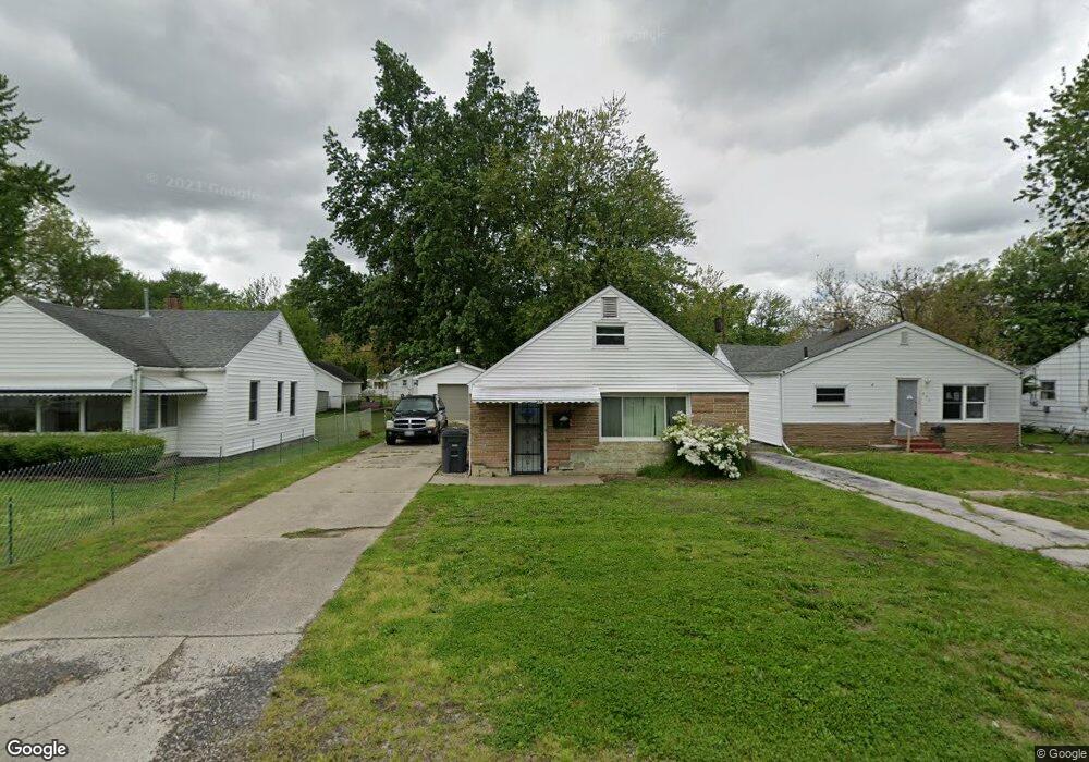
556 Brysen Ave Toledo, OH 43609
Southside NeighborhoodEstimated Value: $77,000 - $99,236
3
Beds
2
Baths
1,290
Sq Ft
$70/Sq Ft
Est. Value
About This Home
This home is located at 556 Brysen Ave, Toledo, OH 43609 and is currently estimated at $89,809, approximately $69 per square foot. 556 Brysen Ave is a home located in Lucas County with nearby schools including Reynolds Elementary School, Rogers High School, and Explorers Academy of Science and Technology.
Ownership History
Date
Name
Owned For
Owner Type
Purchase Details
Closed on
Dec 24, 2008
Sold by
Dandino Abbott Denise A
Bought by
Dandino Matthew R
Current Estimated Value
Home Financials for this Owner
Home Financials are based on the most recent Mortgage that was taken out on this home.
Original Mortgage
$49,348
Outstanding Balance
$32,628
Interest Rate
6.06%
Mortgage Type
FHA
Estimated Equity
$57,181
Purchase Details
Closed on
Aug 29, 2005
Sold by
Dandino Richard Eugene and Dandino Patricia Ann
Bought by
Dandino Richard E and Dandino Patricia A
Create a Home Valuation Report for This Property
The Home Valuation Report is an in-depth analysis detailing your home's value as well as a comparison with similar homes in the area
Home Values in the Area
Average Home Value in this Area
Purchase History
| Date | Buyer | Sale Price | Title Company |
|---|---|---|---|
| Dandino Matthew R | $50,000 | Attorney | |
| Dandino Richard E | -- | -- |
Source: Public Records
Mortgage History
| Date | Status | Borrower | Loan Amount |
|---|---|---|---|
| Open | Dandino Matthew R | $49,348 |
Source: Public Records
Tax History Compared to Growth
Tax History
| Year | Tax Paid | Tax Assessment Tax Assessment Total Assessment is a certain percentage of the fair market value that is determined by local assessors to be the total taxable value of land and additions on the property. | Land | Improvement |
|---|---|---|---|---|
| 2024 | $697 | $21,525 | $4,970 | $16,555 |
| 2023 | $1,270 | $18,655 | $4,025 | $14,630 |
| 2022 | $1,259 | $18,655 | $4,025 | $14,630 |
| 2021 | $1,302 | $18,655 | $4,025 | $14,630 |
| 2020 | $1,253 | $15,575 | $3,325 | $12,250 |
| 2019 | $1,209 | $15,575 | $3,325 | $12,250 |
| 2018 | $1,329 | $15,575 | $3,325 | $12,250 |
| 2017 | $1,245 | $15,540 | $3,010 | $12,530 |
| 2016 | $1,254 | $44,400 | $8,600 | $35,800 |
| 2015 | $1,444 | $44,400 | $8,600 | $35,800 |
| 2014 | $977 | $15,540 | $3,010 | $12,530 |
| 2013 | $977 | $15,540 | $3,010 | $12,530 |
Source: Public Records
Map
Nearby Homes
- 546 Elmdale Rd
- 638 Foredale Ave
- 560 Williamsville Ave
- 728 Foredale Ave
- 552 Wyman St
- 2828 South Ave
- 710 Durango Dr
- 576 Bronx Dr
- 556 Apple Ave
- 1351 Bensch Dr
- 3546 Denise Dr
- 1302 E Beverly Hills Dr
- 304 Mayberry St
- 2126 Airport Hwy
- 620 Broer Ave
- 642 MacKow Dr
- 615 Cuthbert Rd
- 321 Mayberry St
- 732 Moran Ave
- 326 Independence Rd
- 552 Brysen Ave
- 560 Brysen Ave
- 546 Brysen Ave
- 564 Brysen Ave
- 555 Foredale Ave
- 551 Foredale Ave
- 559 Foredale Ave
- 545 Foredale Ave
- 604 Brysen Ave
- 563 Foredale Ave
- 555 Brysen Ave
- 559 Brysen Ave
- 603 Foredale Ave
- 608 Brysen Ave
- 533 Brysen Ave
- 545 Brysen Ave
- 533 Foredale Ave
- 539 Brysen Ave
- 607 Foredale Ave
- 528 Brysen Ave