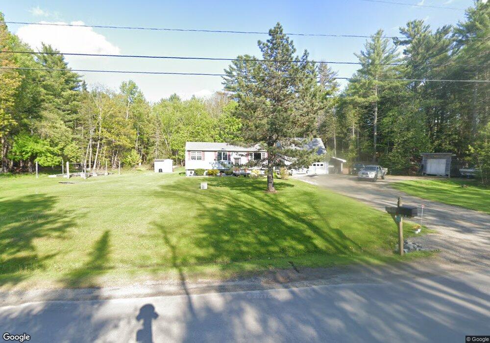
556 Johnson Mill Rd Orrington, ME 04474
Estimated Value: $245,000 - $491,000
Studio
--
Bath
--
Sq Ft
1.7
Acres
About This Home
This home is located at 556 Johnson Mill Rd, Orrington, ME 04474 and is currently estimated at $336,805. 556 Johnson Mill Rd is a home located in Penobscot County with nearby schools including Center Drive School and Calvary Chapel Christian School.
Ownership History
Date
Name
Owned For
Owner Type
Purchase Details
Closed on
Dec 22, 2005
Sold by
Babine Richard A
Bought by
Hodgins Timothy J and Hodgins Kathleen A
Current Estimated Value
Home Financials for this Owner
Home Financials are based on the most recent Mortgage that was taken out on this home.
Original Mortgage
$128,000
Outstanding Balance
$71,914
Interest Rate
6.36%
Mortgage Type
Commercial
Estimated Equity
$264,891
Create a Home Valuation Report for This Property
The Home Valuation Report is an in-depth analysis detailing your home's value as well as a comparison with similar homes in the area
Home Values in the Area
Average Home Value in this Area
Purchase History
| Date | Buyer | Sale Price | Title Company |
|---|---|---|---|
| Hodgins Timothy J | -- | -- |
Source: Public Records
Mortgage History
| Date | Status | Borrower | Loan Amount |
|---|---|---|---|
| Open | Hodgins Timothy J | $128,000 |
Source: Public Records
Tax History
| Year | Tax Paid | Tax Assessment Tax Assessment Total Assessment is a certain percentage of the fair market value that is determined by local assessors to be the total taxable value of land and additions on the property. | Land | Improvement |
|---|---|---|---|---|
| 2024 | $2,520 | $231,200 | $49,500 | $181,700 |
| 2023 | $2,401 | $218,300 | $46,100 | $172,200 |
| 2022 | $2,507 | $196,600 | $46,100 | $150,500 |
| 2021 | $2,589 | $172,600 | $46,100 | $126,500 |
| 2020 | $2,603 | $163,700 | $46,100 | $117,600 |
| 2019 | $2,603 | $163,700 | $46,100 | $117,600 |
| 2018 | $2,275 | $163,700 | $46,100 | $117,600 |
| 2017 | $2,275 | $163,700 | $46,100 | $117,600 |
| 2016 | $2,091 | $145,700 | $40,600 | $105,100 |
| 2015 | $2,091 | $145,700 | $40,600 | $105,100 |
| 2014 | $2,098 | $146,200 | $40,600 | $105,600 |
| 2013 | $1,966 | $146,200 | $40,600 | $105,600 |
Source: Public Records
Map
Nearby Homes
- 290 Center Dr
- 245 Center Dr
- 173 Center Dr
- 473 Center Dr
- 1002 River Rd
- 1088 Center Dr
- 65F Dr
- 40 Bartlett Cove Dr
- M14 L23A Ferry Rd
- 119 Mill Creek Rd
- 59 Summer St
- 42 Fowler Rd
- 12 Harvest Dr
- 38 Harvest Dr
- 46 Albert Reed Rd
- Lot 3 00 Stonewall Dr
- Lot 4 00 Stonewall Dr
- 420 Main Rd S
- Map4Lot3 E Bucksport Rd
- 17 Kennebec Rd
- 544 Johnson Mill Rd
- 27 Clark Falls Rd
- 15 Clark Falls Rd
- 570 Johnson Mill Rd
- 0 Clark Falls Rd
- 21 Clark Falls Rd
- 12 Clark Falls Rd
- 69 Clark Falls Rd
- 22 Clark Falls Rd
- 33 Clark Falls Rd
- 531 Johnson Mill Rd
- 523 Johnson Mill Rd
- 36 Clark Falls Rd
- 36 Clark Falls Rd
- - Clark Falls Rd
- 53 Clark Falls Rd
- 507 Johnson Mill Rd
- 498 Johnson Mill Rd
- 515 Johnson Mill Rd
- 512 Johnson Mill Rd
Your Personal Tour Guide
Ask me questions while you tour the home.