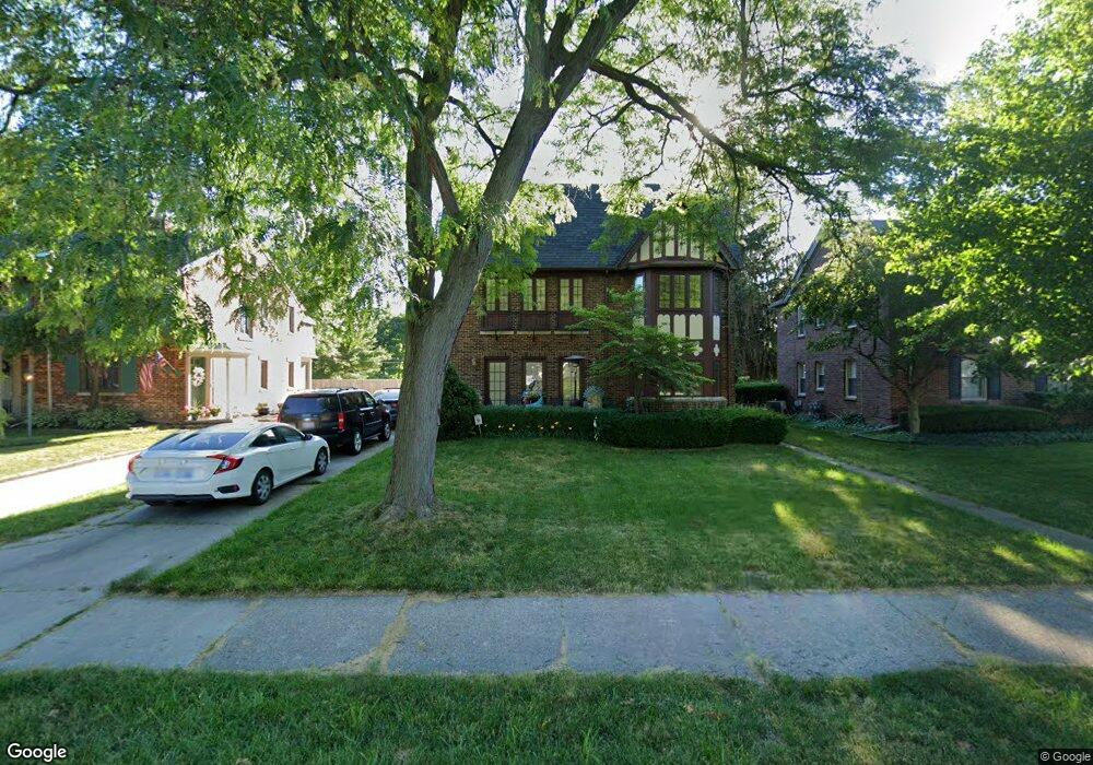
556 Neff Rd Grosse Pointe, MI 48230
Estimated Value: $531,382 - $800,000
Studio
--
Bath
3,334
Sq Ft
$189/Sq Ft
Est. Value
About This Home
This home is located at 556 Neff Rd, Grosse Pointe, MI 48230 and is currently estimated at $631,096, approximately $189 per square foot. 556 Neff Rd is a home located in Wayne County with nearby schools including Lewis Maire Elementary School, Pierce Middle School, and Grosse Pointe South High School.
Ownership History
Date
Name
Owned For
Owner Type
Purchase Details
Closed on
Nov 8, 2017
Sold by
Geshel Gregory C and Elaine L Geshel Trust
Bought by
Geshel Gregory C and Paul E Greshel Trust
Current Estimated Value
Purchase Details
Closed on
Oct 11, 2017
Sold by
Plante Moran Trust
Bought by
Plante Moran Trust
Purchase Details
Closed on
Oct 13, 2006
Sold by
Geshel Paul and Geshel Elaine
Bought by
The Elaine L Geshel Trust
Purchase Details
Closed on
Jan 18, 2005
Sold by
Secco Johnny Paul
Bought by
Geshel Paul and Geshel Elaine
Create a Home Valuation Report for This Property
The Home Valuation Report is an in-depth analysis detailing your home's value as well as a comparison with similar homes in the area
Home Values in the Area
Average Home Value in this Area
Purchase History
| Date | Buyer | Sale Price | Title Company |
|---|---|---|---|
| Geshel Gregory C | -- | None Available | |
| Plante Moran Trust | -- | None Available | |
| The Elaine L Geshel Trust | -- | None Available | |
| Geshel Paul | $395,000 | Metropolitan Title Company |
Source: Public Records
Tax History
| Year | Tax Paid | Tax Assessment Tax Assessment Total Assessment is a certain percentage of the fair market value that is determined by local assessors to be the total taxable value of land and additions on the property. | Land | Improvement |
|---|---|---|---|---|
| 2025 | $5,246 | $258,600 | $0 | $0 |
| 2024 | $5,070 | $249,600 | $0 | $0 |
| 2023 | $4,835 | $242,100 | $0 | $0 |
| 2022 | $8,862 | $220,400 | $0 | $0 |
| 2021 | $8,628 | $205,400 | $0 | $0 |
| 2019 | $8,493 | $175,100 | $0 | $0 |
| 2018 | $4,196 | $153,800 | $0 | $0 |
| 2017 | $7,290 | $152,000 | $0 | $0 |
| 2016 | $7,690 | $144,200 | $0 | $0 |
| 2015 | $11,976 | $132,700 | $0 | $0 |
| 2013 | $11,602 | $121,700 | $0 | $0 |
| 2012 | -- | $113,300 | $0 | $0 |
Source: Public Records
Map
Nearby Homes
- 516 Neff Ln
- 25 Village Ln
- 379 Lakeland St
- 612 Cadieux Rd
- 47 Cranford Ln
- 614 Rivard Blvd
- 42 Cranford Ln
- 30 Cranford Ln
- 345 Roosevelt Place
- 355 Lincoln Rd
- 386 Notre Dame St
- 775 Notre Dame St
- 296 Rivard Blvd
- 1030 Bishop Rd
- 781 Loraine St
- 277 Lincoln Rd
- 180 Fisher Rd
- 1264 Bishop Rd
- 29 Fisher Rd
- 11 Wellington Place
Your Personal Tour Guide
Ask me questions while you tour the home.