Estimated Value: $239,000 - $270,000
3
Beds
2
Baths
1,118
Sq Ft
$229/Sq Ft
Est. Value
About This Home
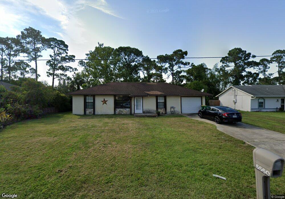
This home is located at 5560 Flint Rd, Cocoa, FL 32927 and is currently estimated at $256,302, approximately $229 per square foot. 5560 Flint Rd is a home located in Brevard County with nearby schools including Enterprise Elementary School, Space Coast Junior/Senior High School, and East Atlantic Prep of Brevard County.
Ownership History
Date
Name
Owned For
Owner Type
Purchase Details
Closed on
Jun 5, 2017
Sold by
Johnson Samuel L and Johnson Camellia P
Bought by
Johnson Samuel L and Johnson Camellia P
Current Estimated Value
Purchase Details
Closed on
Oct 15, 2015
Sold by
Vincur Robert M
Bought by
Johnson Samuel L
Home Financials for this Owner
Home Financials are based on the most recent Mortgage that was taken out on this home.
Original Mortgage
$85,914
Interest Rate
4.75%
Mortgage Type
FHA
Create a Home Valuation Report for This Property
The Home Valuation Report is an in-depth analysis detailing your home's value as well as a comparison with similar homes in the area
Home Values in the Area
Average Home Value in this Area
Purchase History
| Date | Buyer | Sale Price | Title Company |
|---|---|---|---|
| Johnson Samuel L | $42,300 | Attorney | |
| Johnson Samuel L | $87,500 | Attorney |
Source: Public Records
Mortgage History
| Date | Status | Borrower | Loan Amount |
|---|---|---|---|
| Previous Owner | Johnson Samuel L | $85,914 |
Source: Public Records
Tax History
| Year | Tax Paid | Tax Assessment Tax Assessment Total Assessment is a certain percentage of the fair market value that is determined by local assessors to be the total taxable value of land and additions on the property. | Land | Improvement |
|---|---|---|---|---|
| 2025 | $2,891 | $192,330 | -- | -- |
| 2024 | $2,827 | $195,870 | -- | -- |
| 2023 | $2,827 | $195,380 | $0 | $0 |
| 2022 | $2,564 | $185,990 | $0 | $0 |
| 2021 | $2,325 | $138,760 | $42,000 | $96,760 |
| 2020 | $2,143 | $124,500 | $40,000 | $84,500 |
| 2019 | $2,023 | $119,620 | $35,000 | $84,620 |
| 2018 | $1,916 | $108,460 | $27,000 | $81,460 |
| 2017 | $1,828 | $96,850 | $24,000 | $72,850 |
| 2016 | $1,712 | $82,360 | $18,000 | $64,360 |
| 2015 | $1,518 | $63,840 | $15,000 | $48,840 |
| 2014 | $1,390 | $58,040 | $11,000 | $47,040 |
Source: Public Records
Map
Nearby Homes
- 6438 Hudson Rd
- 6481 La Brea Ave
- 5720 Flint Rd
- 5715 Fairbridge St
- 6450 Ember Ave
- 5220 Holden Rd
- 5946 Deer Ln
- 5215 Holden Rd
- 5221 Carrick Rd
- 6581 Bancroft Ave
- 5945 Coker Ave
- 6615 Dock Ave
- 6020 Cannon Ave
- 00 Unknown
- 6365 Homestead Ave
- 23-35-21-JX-B-2 Aruin St
- 6094 Cardiff Ave
- 6010 Fay Blvd
- 6375 Cable Ave
- 6760 Cairo Rd
Your Personal Tour Guide
Ask me questions while you tour the home.