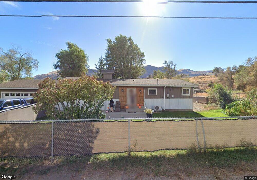
5560 Rock Island Rd Rock Island, WA 98850
Estimated Value: $427,877 - $491,000
3
Beds
1
Bath
1,288
Sq Ft
$358/Sq Ft
Est. Value
About This Home
This home is located at 5560 Rock Island Rd, Rock Island, WA 98850 and is currently estimated at $460,469, approximately $357 per square foot. 5560 Rock Island Rd is a home located in Douglas County with nearby schools including Rock Island Elementary School, Clovis Point Intermediate School, and Eastmont Junior High School.
Ownership History
Date
Name
Owned For
Owner Type
Purchase Details
Closed on
Apr 16, 2024
Sold by
Coy Joyce E and Drake Denise R
Bought by
Drake Denise R Coy
Current Estimated Value
Purchase Details
Closed on
Jan 12, 2023
Sold by
Coy Joyce E
Bought by
Coy Joyce E
Purchase Details
Closed on
Jan 22, 2020
Sold by
Coy Joyce E
Bought by
Coy Joyce E and Coy Darren R
Purchase Details
Closed on
Jul 23, 1980
Sold by
Pierce Henry and Pierce Louise
Bought by
Coy Wallace and Coy Joyce
Create a Home Valuation Report for This Property
The Home Valuation Report is an in-depth analysis detailing your home's value as well as a comparison with similar homes in the area
Home Values in the Area
Average Home Value in this Area
Purchase History
| Date | Buyer | Sale Price | Title Company |
|---|---|---|---|
| Drake Denise R Coy | -- | None Listed On Document | |
| Coy Joyce E | -- | -- | |
| Coy Joyce E | -- | None Available | |
| Coy Wallace | $127,424 | Security Title Insurance Co |
Source: Public Records
Tax History Compared to Growth
Tax History
| Year | Tax Paid | Tax Assessment Tax Assessment Total Assessment is a certain percentage of the fair market value that is determined by local assessors to be the total taxable value of land and additions on the property. | Land | Improvement |
|---|---|---|---|---|
| 2025 | $2,640 | $363,800 | $122,400 | $241,400 |
| 2024 | $2,640 | $320,000 | $89,000 | $231,000 |
| 2023 | $2,941 | $302,900 | $89,000 | $213,900 |
| 2022 | $3,106 | $305,400 | $89,000 | $216,400 |
| 2021 | $3,400 | $305,400 | $89,000 | $216,400 |
| 2020 | $2,571 | $305,400 | $89,000 | $216,400 |
| 2018 | $1,835 | $154,000 | $80,900 | $73,100 |
| 2017 | $1,704 | $154,000 | $80,900 | $73,100 |
| 2016 | $1,751 | $154,000 | $80,900 | $73,100 |
| 2015 | $1,826 | $154,000 | $80,900 | $73,100 |
| 2014 | -- | $154,000 | $80,900 | $73,100 |
| 2013 | -- | $148,600 | $80,900 | $67,700 |
Source: Public Records
Map
Nearby Homes
- 1366 Theo Way
- 1344 Theo Way
- 1611 Douglas St
- 0 Pear Ln
- 5060 Washington 28
- 0 NNA Rock Island Dr
- 7 Cambridge Ave
- 1550 Pear Ln
- 105 3rd St SW
- 1114 Wells St
- 5097 Malaga Alcoa Hwy
- 352 Hammond Ln
- 428 Hammond Ln
- 583 S Webb Ave
- 559 S Webb Ave
- 539 S Webb Ave
- 95 Laurel Estates
- 6856 Batterman Rd
- 0 Ward St
- 0 S Valiant Dr Unit 18 NWM2392419
- 5570 Rock Island Rd
- 5531 Rock Island Rd
- 5590 Rock Island Rd
- 5594 Rock Island Rd
- 5539 Rock Island Rd
- 1604 Morgan Blvd
- 1607 Morgan Blvd
- 1609 Morgan Blvd
- 5650 Rock Island Rd
- 5529 Rock Island Rd
- 5500 Rock Island Rd
- 1606 Morgan Blvd
- 5600 Evan Ave
- 1611 Morgan Blvd
- 1608 Morgan Blvd
- 5660 Rock Island Rd
- 5602 Evan Ave
- 1613 Morgan Blvd
- 1658 Center St
- 1610 Morgan Blvd