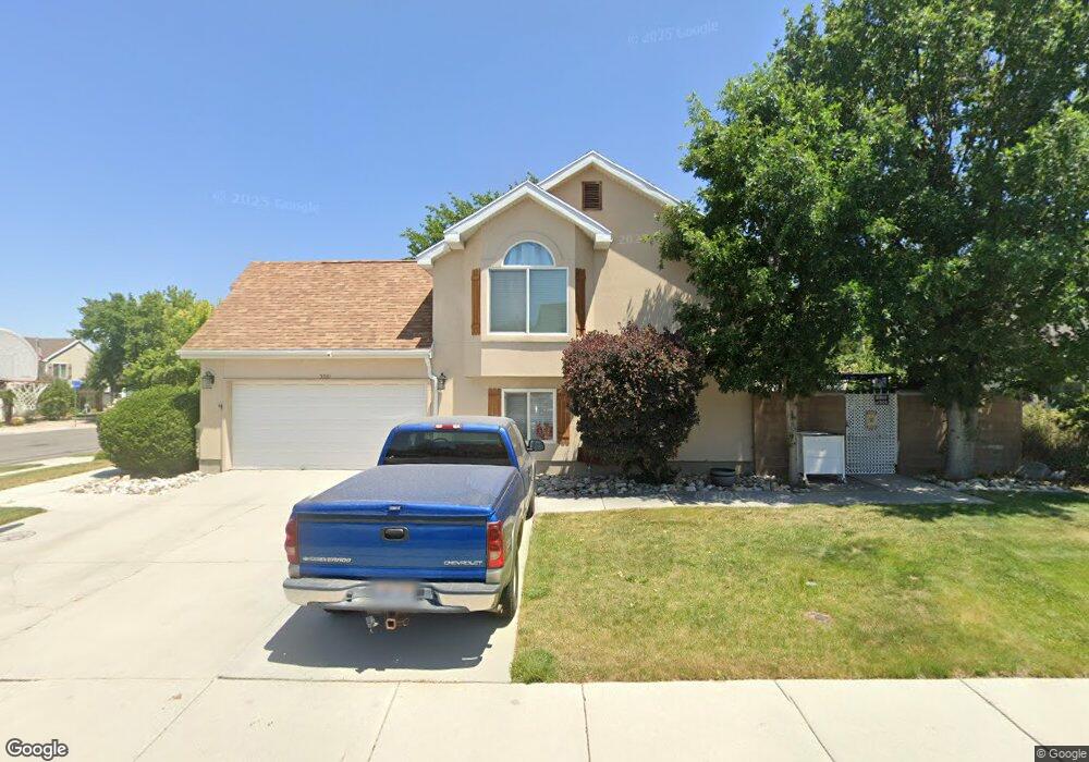
5561 S Crosspark Dr Salt Lake City, UT 84123
Estimated Value: $536,000 - $564,097
4
Beds
2
Baths
1,880
Sq Ft
$295/Sq Ft
Est. Value
About This Home
This home is located at 5561 S Crosspark Dr, Salt Lake City, UT 84123 and is currently estimated at $553,774, approximately $294 per square foot. 5561 S Crosspark Dr is a home located in Salt Lake County with nearby schools including Plymouth Elementary School, Eisenhower Jr High School, and Taylorsville High School.
Ownership History
Date
Name
Owned For
Owner Type
Purchase Details
Closed on
Dec 23, 2020
Sold by
Gaston Claudia
Bought by
Gaston Claudia and Bethers Forrest R
Current Estimated Value
Home Financials for this Owner
Home Financials are based on the most recent Mortgage that was taken out on this home.
Original Mortgage
$310,500
Outstanding Balance
$276,301
Interest Rate
2.8%
Mortgage Type
New Conventional
Estimated Equity
$277,473
Purchase Details
Closed on
Nov 3, 2020
Sold by
Barr Kacy and Barr Gregory
Bought by
Gaston Claudia
Home Financials for this Owner
Home Financials are based on the most recent Mortgage that was taken out on this home.
Original Mortgage
$310,500
Outstanding Balance
$276,301
Interest Rate
2.8%
Mortgage Type
New Conventional
Estimated Equity
$277,473
Purchase Details
Closed on
Dec 8, 2015
Sold by
Barr Kacy and Pryor Kacy
Bought by
Barr Kacy and Barr Gregory
Purchase Details
Closed on
May 28, 2009
Sold by
Augason Mark P
Bought by
Pryor Kacy
Home Financials for this Owner
Home Financials are based on the most recent Mortgage that was taken out on this home.
Original Mortgage
$223,870
Interest Rate
4.76%
Mortgage Type
FHA
Purchase Details
Closed on
Dec 3, 2004
Sold by
Augason Phillip A and Augason Philip A
Bought by
Augason Philip Abner and The Rosenlof Trust
Purchase Details
Closed on
Apr 25, 2003
Sold by
Olson Thomas Clayton and Olson Annetta M
Bought by
Augason Mark P and Augason Phillip A
Home Financials for this Owner
Home Financials are based on the most recent Mortgage that was taken out on this home.
Original Mortgage
$110,000
Interest Rate
5.84%
Mortgage Type
Purchase Money Mortgage
Purchase Details
Closed on
May 6, 1999
Sold by
Olson Thomas Clayton
Bought by
Olson Thomas Clayton and Olson Annetta M
Home Financials for this Owner
Home Financials are based on the most recent Mortgage that was taken out on this home.
Original Mortgage
$128,400
Interest Rate
6.96%
Mortgage Type
Purchase Money Mortgage
Create a Home Valuation Report for This Property
The Home Valuation Report is an in-depth analysis detailing your home's value as well as a comparison with similar homes in the area
Home Values in the Area
Average Home Value in this Area
Purchase History
| Date | Buyer | Sale Price | Title Company |
|---|---|---|---|
| Gaston Claudia | -- | Sutherland Title | |
| Gaston Claudia | -- | Title Guarantee | |
| Barr Kacy | -- | Vantage Point Title | |
| Pryor Kacy | -- | Highland Title Agency | |
| Augason Mark P | -- | Highland Title Agency | |
| Augason Philip Abner | -- | -- | |
| Augason Mark P | -- | Millcreek Land Title Ins | |
| Olson Thomas Clayton | -- | Paramount Title | |
| Olson Thomas Clayton | -- | Paramount Title |
Source: Public Records
Mortgage History
| Date | Status | Borrower | Loan Amount |
|---|---|---|---|
| Open | Gaston Claudia | $310,500 | |
| Previous Owner | Pryor Kacy | $223,870 | |
| Previous Owner | Augason Mark P | $110,000 | |
| Previous Owner | Olson Thomas Clayton | $128,400 |
Source: Public Records
Tax History Compared to Growth
Tax History
| Year | Tax Paid | Tax Assessment Tax Assessment Total Assessment is a certain percentage of the fair market value that is determined by local assessors to be the total taxable value of land and additions on the property. | Land | Improvement |
|---|---|---|---|---|
| 2025 | $3,303 | $537,700 | $142,100 | $395,600 |
| 2024 | $3,303 | $520,600 | $137,600 | $383,000 |
| 2023 | $3,165 | $499,800 | $128,600 | $371,200 |
| 2022 | $3,370 | $509,400 | $126,100 | $383,300 |
| 2021 | $2,769 | $391,300 | $97,000 | $294,300 |
| 2020 | $2,400 | $321,000 | $89,200 | $231,800 |
| 2019 | $2,423 | $316,500 | $89,200 | $227,300 |
| 2018 | $2,222 | $279,800 | $86,300 | $193,500 |
| 2017 | $1,983 | $262,500 | $86,300 | $176,200 |
| 2016 | $1,822 | $240,900 | $86,300 | $154,600 |
| 2015 | $1,922 | $237,500 | $88,000 | $149,500 |
| 2014 | $1,848 | $224,300 | $83,900 | $140,400 |
Source: Public Records
Map
Nearby Homes
- 1443 W Spinnaker Row Unit 96
- 5449 S Coastal Ct
- 5435 S Break Water Dr
- 1380 W Ocean Ct
- 1334 Portside Way Unit 165
- 1273 W Brister Dr
- 1401 Beacon Hill Dr Unit 118
- 1381 Beacon Hill Dr
- 5920 S 1300 W
- 5552 Hew Wood Dr
- 2001 W 5540 S
- 1886 W Champagne Ave
- 1193 W Dun Robin Ct
- 903 W Bullion St
- 913 W Bullion St Unit 10
- 6089 Himrod Ct
- 5020 S 1250 W
- Hirst 2 Plan at The Gallery at Bullion - Townhomes
- Caro 2 Plan at The Gallery at Bullion - Townhomes
- Sargent Plan at The Gallery at Bullion - Single Family Homes
- 5561 S Crosspark Dr
- 5573 S Crosspark Dr
- 5573 S Crosspark Dr
- 949 W Coalburn Way
- 949 W Coalburn Way Unit 101
- 949 W Coalburn Way Unit 102
- 957 W Coalburn Way Unit 2-45
- 5562 Crosspointe Ct
- 5572 Crosspointe Ct
- 1487 W 5550 S
- 5562 Crosspark Dr
- 5587 Crosspark Dr
- 1474 W 5550 S
- 5574 Crosspark Dr
- 5582 Crosspointe Ct
- 1452 W 5550 S
- 5582 S Crosspointe Ct
- 5489 S 1500 W
- 5586 Crosspark Dr
- 5480 Crosspointe Cir