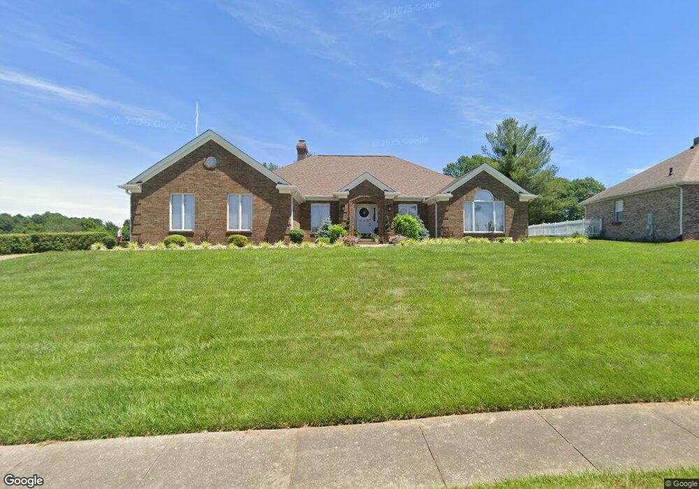
557 St Andrews Vine Grove, KY 40175
Estimated Value: $387,000 - $579,000
3
Beds
4
Baths
4,950
Sq Ft
$96/Sq Ft
Est. Value
About This Home
This home is located at 557 St Andrews, Vine Grove, KY 40175 and is currently estimated at $475,683, approximately $96 per square foot. 557 St Andrews is a home located in Hardin County with nearby schools including Vine Grove Elementary School, James T. Alton Middle School, and North Hardin High School.
Ownership History
Date
Name
Owned For
Owner Type
Purchase Details
Closed on
Aug 24, 2023
Sold by
King Robert W
Bought by
Riggs Christopher and Riggs Melissa
Current Estimated Value
Purchase Details
Closed on
Dec 13, 2022
Sold by
Jantz Gary L and Jantz Rosetta F
Bought by
King Robert W
Purchase Details
Closed on
May 11, 2022
Sold by
Latashia Mcgee
Bought by
King Robert W
Purchase Details
Closed on
Mar 2, 2022
Sold by
Cannon Steven M and Cannon Alanna M
Bought by
King Robert
Purchase Details
Closed on
Feb 23, 2022
Sold by
King Robert P and King George P
Bought by
Patriot Enterprises Llc
Purchase Details
Closed on
Feb 22, 2022
Sold by
Duvall Jr George P and Duvall Melody
Bought by
King Robert
Purchase Details
Closed on
Aug 11, 2021
Sold by
King Robert W
Bought by
Montgomery Carmaletta and Montgomery Melvin O
Purchase Details
Closed on
Aug 6, 2021
Sold by
Garys R & R Llc
Bought by
King Robert W
Purchase Details
Closed on
Aug 25, 2020
Sold by
Estate Of Louise Alton Eubank
Bought by
King Robert W
Purchase Details
Closed on
Jul 8, 2020
Sold by
Palummo Dominie and Palummo Valerie
Bought by
King Robert Wayne
Purchase Details
Closed on
Feb 26, 2020
Sold by
Vanmeter Mary F
Bought by
King Robert W
Purchase Details
Closed on
Jan 17, 2020
Sold by
Duvall George P
Bought by
King Robert
Purchase Details
Closed on
Jun 25, 2019
Sold by
Castillo Jose A and Castillo Sara A
Bought by
King Robert W and Crigler Lea A
Home Financials for this Owner
Home Financials are based on the most recent Mortgage that was taken out on this home.
Original Mortgage
$65,000
Interest Rate
3.9%
Mortgage Type
Stand Alone Refi Refinance Of Original Loan
Purchase Details
Closed on
Mar 30, 2016
Sold by
Castillo Jose A and Castillo Sara A
Bought by
Castillo Jose A and Castillo Sara A
Purchase Details
Closed on
Feb 15, 2016
Sold by
Gray David T and Gray Lois W
Bought by
Castillo Jose A and Castillo Sara A
Create a Home Valuation Report for This Property
The Home Valuation Report is an in-depth analysis detailing your home's value as well as a comparison with similar homes in the area
Home Values in the Area
Average Home Value in this Area
Purchase History
| Date | Buyer | Sale Price | Title Company |
|---|---|---|---|
| Riggs Christopher | $47,000 | Bluegrass Land Title | |
| King Robert W | $99,000 | Bluegrass Land Title | |
| King Robert W | $165,000 | Mitchell & Grant Pllc | |
| King Robert | $60,000 | Bluegrass Land Title | |
| Patriot Enterprises Llc | $50,000 | Kerrick Bachert | |
| King Robert | $32,000 | None Listed On Document | |
| Montgomery Carmaletta | $174,999 | Bluegrass Land Title | |
| King Robert W | $32,000 | Bluegrass Land Title | |
| King Robert W | $460,000 | Bluegrass Land Title Llc | |
| King Robert Wayne | $8,000 | Bluegrass Land Title Llc | |
| King Robert W | $70,000 | None Available | |
| King Robert | $40,000 | Bluegrass Land Title Llc | |
| King Robert | $40,000 | None Available | |
| King Robert W | $325,000 | -- | |
| King Robert W | $325,000 | -- | |
| Castillo Jose A | -- | Attorney | |
| Castillo Jose A | $285,000 | Kinkead Law Office & Title |
Source: Public Records
Mortgage History
| Date | Status | Borrower | Loan Amount |
|---|---|---|---|
| Previous Owner | King Robert W | $65,000 | |
| Previous Owner | King Robert W | $260,000 |
Source: Public Records
Tax History Compared to Growth
Tax History
| Year | Tax Paid | Tax Assessment Tax Assessment Total Assessment is a certain percentage of the fair market value that is determined by local assessors to be the total taxable value of land and additions on the property. | Land | Improvement |
|---|---|---|---|---|
| 2024 | $3,667 | $338,300 | $47,800 | $290,500 |
| 2023 | $3,667 | $338,300 | $47,800 | $290,500 |
| 2022 | $3,174 | $338,300 | $47,800 | $290,500 |
| 2021 | $3,590 | $325,000 | $47,800 | $277,200 |
| 2020 | $3,620 | $325,000 | $47,800 | $277,200 |
| 2019 | $0 | $285,000 | $0 | $0 |
| 2018 | $3,098 | $285,000 | $0 | $0 |
| 2017 | $3,084 | $285,000 | $0 | $0 |
| 2016 | $0 | $290,300 | $0 | $0 |
| 2015 | $2,536 | $290,300 | $0 | $0 |
| 2012 | -- | $290,300 | $0 | $0 |
Source: Public Records
Map
Nearby Homes
- Lot 83 Pebble Beach Ct
- Lot 82 Pebble Beach Ct
- Lot 84 Pebble Beach Ct
- 586 Pinehurst Dr
- 584 Pinehurst Dr
- 578 Pinehurst Dr
- 580 Pinehurst Dr
- 589 Pinehurst Dr
- 587 Pinehurst Dr
- 585 Pinehurst Dr
- KINGSTON Plan at The Landings
- DUPONT Plan at The Landings
- ESSEX Plan at The Landings
- ABERNATHY Plan at The Landings
- 576 Pinehurst Dr
- 575 Pinehurst Dr
- 561 Pinehurst Dr
- 557 Pinehurst Dr
- 155 Sawgrass Ave
- 405 Turnberry Ct
- 557 Saint Andrews Dr
- 559 Saint Andrews Dr
- 555 Saint Andrews Dr
- 555 St Andrews
- 555 St Andrews Unit St. Andrews Dr.
- 556 Saint Andrews Dr
- 554 Saint Andrews Dr
- 558 Saint Andrews Dr
- 561 Saint Andrews Dr
- 553 Saint Andrews Dr
- 701 Augusta Dr
- 901 Spyglass Cir
- 93 Pebble Beach Ct
- 551 Saint Andrews Dr
- 562 Saint Andrews Dr
- 903 Spyglass Cir
- 702 Augusta Dr
- 548-2 Saint Andrews Dr
- 900 Spyglass Cir
- 800 Pebble Beach Ct