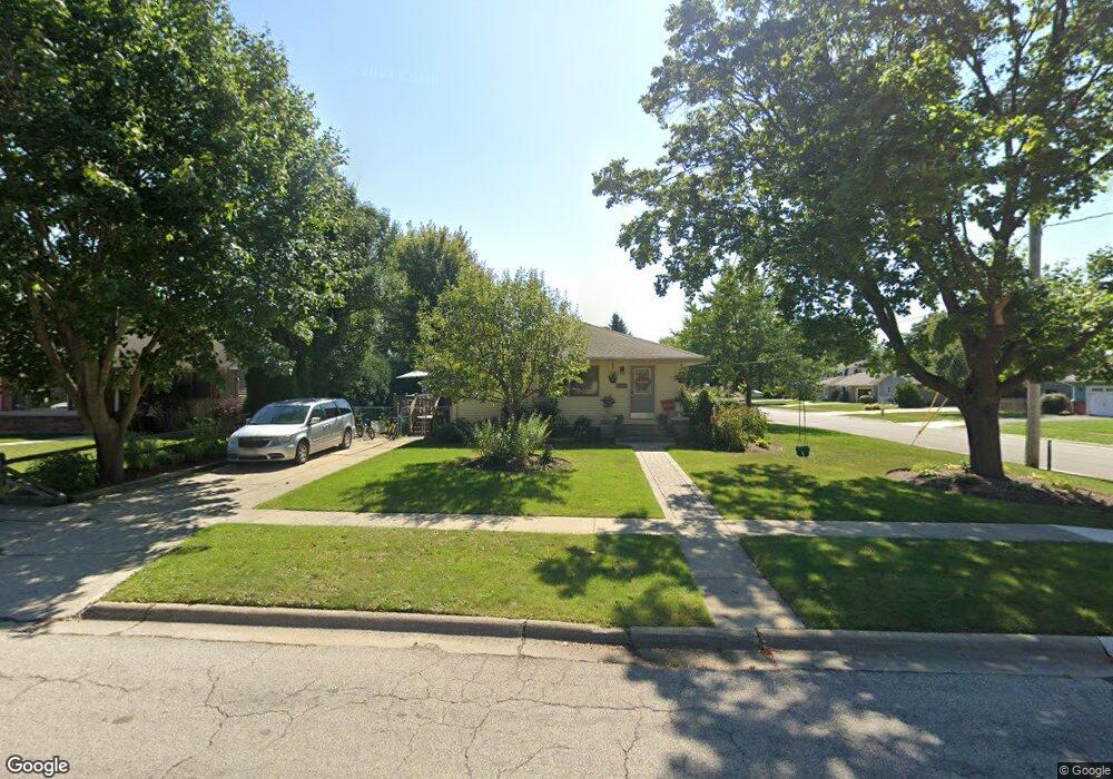
557 W Kimball Ave Woodstock, IL 60098
Estimated Value: $268,000 - $289,000
3
Beds
2
Baths
1,216
Sq Ft
$226/Sq Ft
Est. Value
About This Home
This home is located at 557 W Kimball Ave, Woodstock, IL 60098 and is currently estimated at $274,985, approximately $226 per square foot. 557 W Kimball Ave is a home located in McHenry County with nearby schools including Dean Street Elementary School, Creekside Middle School, and Woodstock High School.
Ownership History
Date
Name
Owned For
Owner Type
Purchase Details
Closed on
Jan 25, 2023
Sold by
Fosnaugh Kathleen A
Bought by
Fosnaughamily Trust and Fosnaugh
Current Estimated Value
Purchase Details
Closed on
Jun 23, 2016
Sold by
Ayala Antonio and Zarate Adriana Tello
Bought by
Ayala Antonio and Ayala Roberto Antonio
Purchase Details
Closed on
Jul 19, 2002
Sold by
Ayala Sergio and Rodriguez Eliceo V
Bought by
Ayala Antonio and Zarate Adriana Tello
Purchase Details
Closed on
Nov 17, 2000
Sold by
West Suburban Bank
Bought by
Ayala Antonio and Ayala Sergio
Home Financials for this Owner
Home Financials are based on the most recent Mortgage that was taken out on this home.
Original Mortgage
$144,508
Interest Rate
7.87%
Mortgage Type
FHA
Create a Home Valuation Report for This Property
The Home Valuation Report is an in-depth analysis detailing your home's value as well as a comparison with similar homes in the area
Home Values in the Area
Average Home Value in this Area
Purchase History
| Date | Buyer | Sale Price | Title Company |
|---|---|---|---|
| Fosnaughamily Trust | -- | None Listed On Document | |
| Ayala Antonio | -- | None Available | |
| Ayala Antonio | -- | -- | |
| Ayala Antonio | $145,700 | -- |
Source: Public Records
Mortgage History
| Date | Status | Borrower | Loan Amount |
|---|---|---|---|
| Previous Owner | Ayala Antonio | $144,508 |
Source: Public Records
Tax History Compared to Growth
Tax History
| Year | Tax Paid | Tax Assessment Tax Assessment Total Assessment is a certain percentage of the fair market value that is determined by local assessors to be the total taxable value of land and additions on the property. | Land | Improvement |
|---|---|---|---|---|
| 2024 | $6,166 | $74,928 | $8,913 | $66,015 |
| 2023 | $5,846 | $67,759 | $8,060 | $59,699 |
| 2022 | $6,274 | $66,850 | $7,153 | $59,697 |
| 2021 | $5,958 | $62,459 | $6,683 | $55,776 |
| 2020 | $5,732 | $59,349 | $6,350 | $52,999 |
| 2019 | $5,557 | $56,652 | $6,061 | $50,591 |
| 2018 | $5,023 | $51,061 | $6,913 | $44,148 |
| 2017 | $4,919 | $48,057 | $6,506 | $41,551 |
| 2016 | $4,859 | $44,497 | $6,024 | $38,473 |
| 2013 | -- | $48,332 | $12,104 | $36,228 |
Source: Public Records
Map
Nearby Homes
- 421 W Kimball Ave
- 155 Lee Ann Ln
- 104 Stewart Ave
- 125 Forest Ave
- 908 Bunker St
- 1004 Golden Ave
- 331 Chestnut St
- 415 Dean St
- 601 S Jefferson St
- 1288 Prairie Ridge Trail
- 3848 Riverwoods Dr
- 3902 Riverwoods Dr
- 3842 Riverwoods Dr
- 3839 Riverwoods Dr
- Townsend Plan at Clublands of Antioch - Horizon Series
- Napa Plan at Clublands of Antioch - Andare Series
- 1249 Prairie Ridge Trail
- 3851 Riverwoods Dr
- 3827 Riverwoods Dr
- Meadowlark Plan at Clublands of Antioch - Horizon Series
- 551 W Kimball Ave
- 545 W Kimball Ave
- 1132 Blakely St
- 1145 Blakely St
- 552 Desmond Dr
- 550 Desmond Dr
- 1031 Blakely St
- 539 W Kimball Ave
- 552 W Kimball Ave
- 611 W Kimball Ave
- 546 W Kimball Ave
- 1148 Blakely St
- 1118 Blakely St
- 1140 Blakely St
- 540 Desmond Dr
- 533 W Kimball Ave
- 540 W Kimball Ave
- 614 W Kimball Ave
- 621 W Kimball Ave
- 534 Desmond Dr