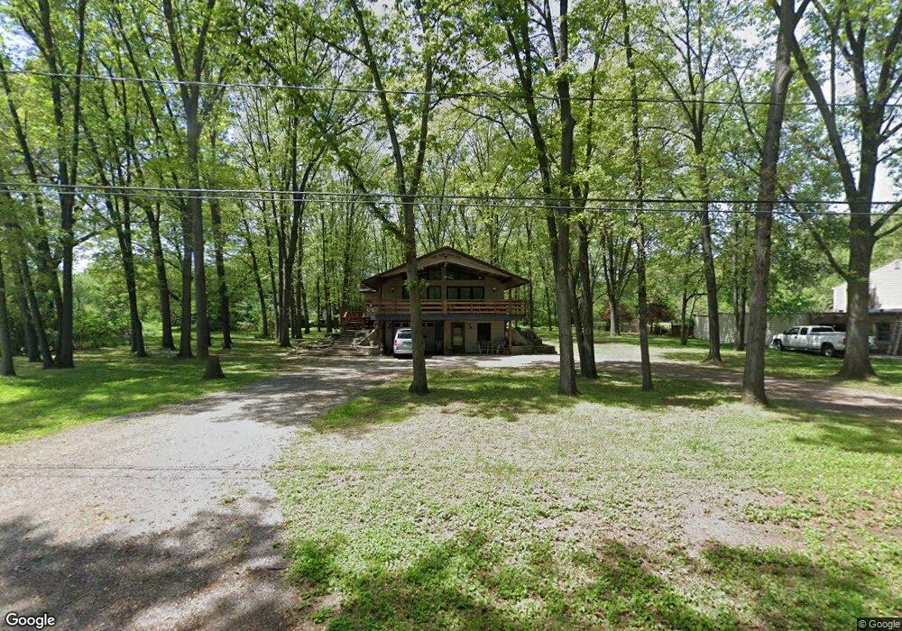
55735 Sheridan Blvd Elkhart, IN 46514
Estimated Value: $232,617 - $275,000
2
Beds
2
Baths
1,280
Sq Ft
$198/Sq Ft
Est. Value
About This Home
This home is located at 55735 Sheridan Blvd, Elkhart, IN 46514 and is currently estimated at $252,904, approximately $197 per square foot. 55735 Sheridan Blvd is a home located in Elkhart County with nearby schools including Cleveland Elementary School, West Side Middle School, and Elkhart High School.
Ownership History
Date
Name
Owned For
Owner Type
Purchase Details
Closed on
Sep 29, 2015
Sold by
Yeater Larry D and Yeater Patricia G
Bought by
Rowe Brandy J and Mcdonald Stormi L
Current Estimated Value
Purchase Details
Closed on
Mar 5, 2009
Sold by
Mcdonald Stormi and Dale Stacey
Bought by
Yeater Larry D and Yeater Patricia G
Purchase Details
Closed on
Sep 2, 2008
Sold by
Yeater Larry D and Yeater Patricia G
Bought by
Mcdonald Stormi and Dale Stacey
Create a Home Valuation Report for This Property
The Home Valuation Report is an in-depth analysis detailing your home's value as well as a comparison with similar homes in the area
Home Values in the Area
Average Home Value in this Area
Purchase History
| Date | Buyer | Sale Price | Title Company |
|---|---|---|---|
| Rowe Brandy J | -- | None Available | |
| Yeater Larry D | -- | None Available | |
| Mcdonald Stormi | -- | Abc Title |
Source: Public Records
Tax History Compared to Growth
Tax History
| Year | Tax Paid | Tax Assessment Tax Assessment Total Assessment is a certain percentage of the fair market value that is determined by local assessors to be the total taxable value of land and additions on the property. | Land | Improvement |
|---|---|---|---|---|
| 2024 | $1,466 | $189,500 | $15,600 | $173,900 |
| 2022 | $1,466 | $155,100 | $15,600 | $139,500 |
| 2021 | $1,207 | $143,200 | $15,600 | $127,600 |
| 2020 | $1,143 | $144,900 | $15,600 | $129,300 |
| 2019 | $1,222 | $136,100 | $15,600 | $120,500 |
| 2018 | $1,196 | $130,400 | $15,600 | $114,800 |
| 2017 | $1,116 | $121,800 | $15,600 | $106,200 |
| 2016 | $1,071 | $118,800 | $15,600 | $103,200 |
| 2014 | $1,047 | $113,100 | $15,600 | $97,500 |
| 2013 | $1,151 | $113,100 | $15,600 | $97,500 |
Source: Public Records
Map
Nearby Homes
- 30690 Old Us Highway 20
- 10059 Jefferson Rd
- VL Campbells Crossover
- 55045 Cobus Ln
- 10181 Mckinley Hwy
- 10199 Mckinley Hwy
- 29942 Connecticut Ave
- 10225 Vistula Rd
- 30175 Wynd Tree Blvd
- 10021 Lanter Ct
- 29595 Old Us 20
- 30586 Carrie Dr
- 30604 Carrie Dr
- 29980 Cardinal Ave
- 56610 Ash Rd
- 56819 Kimberly Dr
- 30372 N Meadow Brook Ln
- 56654 Ash Rd
- 30622 Cynthia Dr
- 10559 Jefferson Blvd
- 55699 Sheridan Blvd
- 55759 Sheridan Blvd
- 30467 Sycamore Ln
- 55783 Sheridan Blvd
- 55659 Sheridan Blvd
- 55670 Sheridan Blvd
- 55744 Merle St
- 55730 Merle St
- 55758 Merle St
- 55645 Sheridan Blvd
- 55760 Merle St
- 55700 Merle St
- 55714 Merle St
- 55805 Sheridan Blvd
- 30450 Britt Ave
- 30431 Sycamore Ln
- 55745 Merle St
- 55729 Merle St
- 30438 Britt Ave
- 30475 N Shore Dr