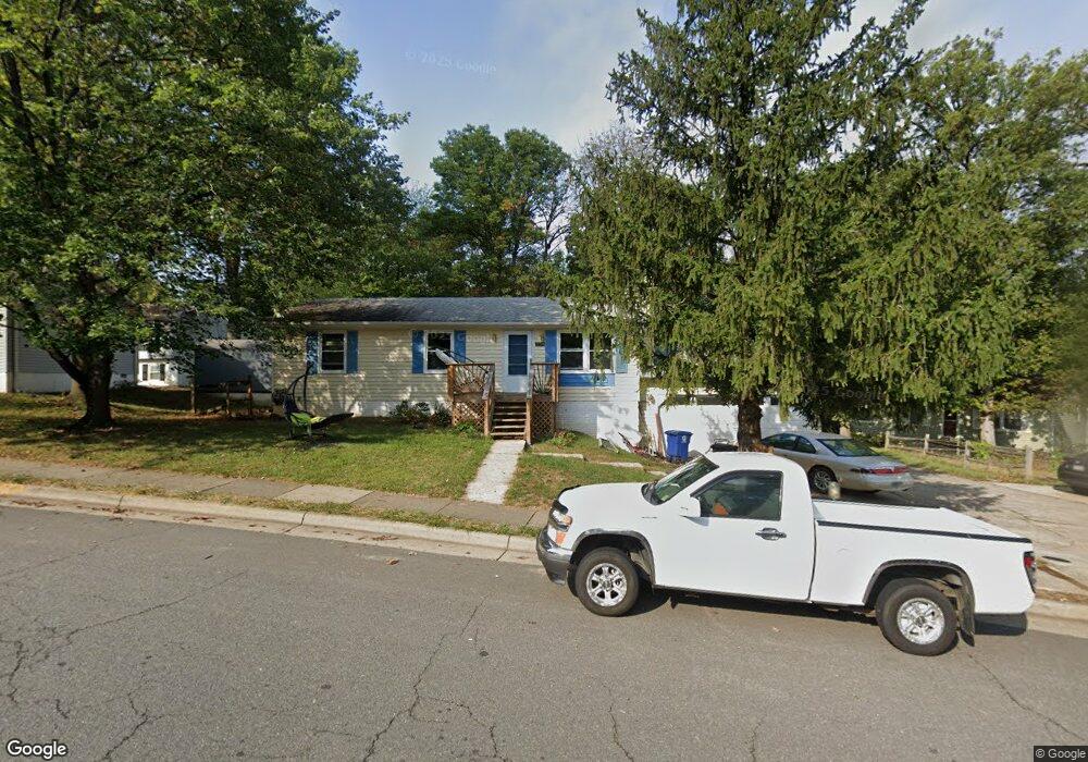
558 Rockbridge Dr SE Leesburg, VA 20175
Estimated Value: $450,000 - $518,000
3
Beds
1
Bath
960
Sq Ft
$510/Sq Ft
Est. Value
About This Home
This home is located at 558 Rockbridge Dr SE, Leesburg, VA 20175 and is currently estimated at $489,980, approximately $510 per square foot. 558 Rockbridge Dr SE is a home located in Loudoun County with nearby schools including Frederick Douglass Elementary School, J. Lupton Simpson Middle School, and Loudoun County High School.
Ownership History
Date
Name
Owned For
Owner Type
Purchase Details
Closed on
Apr 5, 2010
Sold by
Sec Of Housing & Urban Develop
Bought by
Hooberry Christopher R
Current Estimated Value
Home Financials for this Owner
Home Financials are based on the most recent Mortgage that was taken out on this home.
Original Mortgage
$80,000
Outstanding Balance
$53,362
Interest Rate
5.03%
Mortgage Type
New Conventional
Estimated Equity
$436,618
Create a Home Valuation Report for This Property
The Home Valuation Report is an in-depth analysis detailing your home's value as well as a comparison with similar homes in the area
Home Values in the Area
Average Home Value in this Area
Purchase History
| Date | Buyer | Sale Price | Title Company |
|---|---|---|---|
| Hooberry Christopher R | $150,000 | -- |
Source: Public Records
Mortgage History
| Date | Status | Borrower | Loan Amount |
|---|---|---|---|
| Open | Hooberry Christopher R | $80,000 |
Source: Public Records
Tax History Compared to Growth
Tax History
| Year | Tax Paid | Tax Assessment Tax Assessment Total Assessment is a certain percentage of the fair market value that is determined by local assessors to be the total taxable value of land and additions on the property. | Land | Improvement |
|---|---|---|---|---|
| 2025 | $3,788 | $470,570 | $198,500 | $272,070 |
| 2024 | $3,693 | $426,970 | $158,500 | $268,470 |
| 2023 | $3,663 | $418,580 | $158,500 | $260,080 |
| 2022 | $3,226 | $362,490 | $148,500 | $213,990 |
| 2021 | $3,134 | $319,810 | $118,500 | $201,310 |
| 2020 | $3,277 | $316,580 | $118,500 | $198,080 |
| 2019 | $3,091 | $295,820 | $118,500 | $177,320 |
| 2018 | $2,912 | $268,360 | $98,500 | $169,860 |
| 2017 | $2,881 | $256,090 | $98,500 | $157,590 |
| 2016 | $2,879 | $251,450 | $0 | $0 |
| 2015 | $461 | $153,680 | $0 | $153,680 |
| 2014 | $452 | $148,750 | $0 | $148,750 |
Source: Public Records
Map
Nearby Homes
- 589 Rockbridge Dr SE
- 135 Oak View Dr SE
- 214 Shenandoah St SE
- 678 Gateway Dr SE Unit 907
- 664 Gateway Dr SE Unit 314
- 118 Fort Evans Rd SE Unit C
- 101 Fort Evans Rd SE Unit F
- 265 High Rail Terrace SE
- 421 Bicksler Square SE
- 411 Bicksler Square SE
- 459 Kornblau Terrace SE
- 316 Baish Dr SE
- 134 Shirley Square SE
- 202 Murdoch Square SE
- 502 Sunset View Terrace SE Unit 107
- 503 Sunset View Terrace SE Unit 208
- 322 Whipp Dr SE
- 508 Sunset View Terrace SE Unit 208
- 414 Madison Ct SE
- BIRKHALL Plan at Brickyard
- 560 Rockbridge Dr SE
- 556 Rockbridge Dr SE
- 564 Rockbridge Dr SE
- 554 Rockbridge Dr SE
- 566 Rockbridge Dr SE
- 562 Rockbridge Dr SE
- 559 Rockbridge Dr SE
- 553 Rockbridge Dr SE
- 552 Rockbridge Dr SE
- 548 Rockbridge Dr SE
- 557 Rockbridge Dr SE
- 567 Rockbridge Dr SE
- 555 Rockbridge Dr SE
- 550 Rockbridge Dr SE
- 551 Rockbridge Dr SE
- 546 Rockbridge Dr SE
- 106 Oak View Dr SE
- 110 Oak View Dr SE
- 108 Oak View Dr SE
- 568 Rockbridge Dr SE