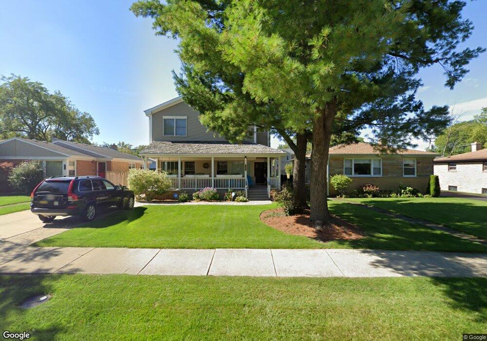
558 Sumac Rd Highland Park, IL 60035
West Highland Park NeighborhoodEstimated Value: $638,000 - $1,158,000
3
Beds
3
Baths
2,725
Sq Ft
$311/Sq Ft
Est. Value
About This Home
This home is located at 558 Sumac Rd, Highland Park, IL 60035 and is currently estimated at $847,555, approximately $311 per square foot. 558 Sumac Rd is a home located in Lake County with nearby schools including Sherwood Elementary School, Edgewood Middle School, and Treasure Valley Leadership Academy.
Ownership History
Date
Name
Owned For
Owner Type
Purchase Details
Closed on
Dec 6, 2023
Sold by
Gordon Shawn M and Gordon Theresa M
Bought by
Gordon Family Trust and Gordon
Current Estimated Value
Purchase Details
Closed on
Mar 31, 1998
Sold by
Kritikos Katherine Taglis
Bought by
Gordon Shawn M and Gordon Theresa M
Home Financials for this Owner
Home Financials are based on the most recent Mortgage that was taken out on this home.
Original Mortgage
$174,675
Interest Rate
7.09%
Mortgage Type
VA
Purchase Details
Closed on
Dec 1, 1995
Sold by
Kritikos Tasos and Kritikos Katherine Taglas
Bought by
Kritikos Katherine Taglas
Purchase Details
Closed on
Oct 17, 1994
Sold by
Kritikos Tasos and Kritikos Katherine
Bought by
Kritikos Tasos and Kritikos Katherine
Create a Home Valuation Report for This Property
The Home Valuation Report is an in-depth analysis detailing your home's value as well as a comparison with similar homes in the area
Home Values in the Area
Average Home Value in this Area
Purchase History
| Date | Buyer | Sale Price | Title Company |
|---|---|---|---|
| Gordon Family Trust | -- | None Listed On Document | |
| Gordon Shawn M | $170,000 | Chicago Title Insurance Co | |
| Kritikos Katherine Taglas | -- | -- | |
| Kritikos Tasos | -- | -- |
Source: Public Records
Mortgage History
| Date | Status | Borrower | Loan Amount |
|---|---|---|---|
| Previous Owner | Gordon Shawn M | $174,675 |
Source: Public Records
Tax History
| Year | Tax Paid | Tax Assessment Tax Assessment Total Assessment is a certain percentage of the fair market value that is determined by local assessors to be the total taxable value of land and additions on the property. | Land | Improvement |
|---|---|---|---|---|
| 2024 | $14,925 | $197,519 | $44,137 | $153,382 |
| 2023 | $14,905 | $178,042 | $39,785 | $138,257 |
| 2022 | $14,905 | $171,424 | $43,707 | $127,717 |
| 2021 | $13,736 | $165,707 | $42,249 | $123,458 |
| 2020 | $13,291 | $165,707 | $42,249 | $123,458 |
| 2019 | $12,845 | $164,931 | $42,051 | $122,880 |
| 2018 | $13,263 | $179,979 | $46,603 | $133,376 |
| 2017 | $13,056 | $178,941 | $46,334 | $132,607 |
| 2016 | $12,581 | $170,355 | $44,111 | $126,244 |
| 2015 | $12,175 | $158,278 | $40,984 | $117,294 |
| 2014 | $12,761 | $161,825 | $40,097 | $121,728 |
| 2012 | $10,513 | $162,769 | $40,331 | $122,438 |
Source: Public Records
Map
Nearby Homes
- 626 Barberry Rd
- 666 Barberry Rd
- 645 Ridge Rd
- 1816 Rosemary Rd
- 1490 Avignon Ct
- 370 Briar Ln
- 309 Ridge Rd
- 326 Briar Ln
- 1039 Deerfield Place Unit 1039
- 50 Red Oak Ln
- 1795 Lake Cook Rd Unit 207
- 1795 Lake Cook Rd Unit 110
- 971 Windsor Rd
- 689 Crofton Ave S
- 1125 Lake Cook Rd Unit 209
- 1280 Rudolph Rd Unit 1F
- 1220 Rudolph Rd Unit 3H
- 1220 Rudolph Rd Unit 1B
- 850 Evergreen Way
- 520 Standish Dr