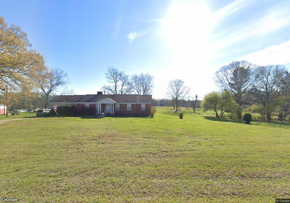
5580 Keith Rd Hogansville, GA 30230
Estimated Value: $354,106 - $422,000
3
Beds
2
Baths
1,962
Sq Ft
$196/Sq Ft
Est. Value
About This Home
This home is located at 5580 Keith Rd, Hogansville, GA 30230 and is currently estimated at $385,027, approximately $196 per square foot. 5580 Keith Rd is a home located in Meriwether County with nearby schools including George E. Washington Elementary School.
Ownership History
Date
Name
Owned For
Owner Type
Purchase Details
Closed on
May 18, 2012
Sold by
Powers Judith Ann Keith
Bought by
Ivey Tondra Marie and Powers Frank J
Current Estimated Value
Purchase Details
Closed on
Mar 7, 2000
Sold by
Keith Tom W Estate
Bought by
Keith Mary Joe Echol
Purchase Details
Closed on
Jan 1, 1968
Sold by
Maynard Keith
Bought by
Keith Tom W
Purchase Details
Closed on
Jan 1, 1958
Sold by
Keith Maynard
Bought by
Maynard Keith
Create a Home Valuation Report for This Property
The Home Valuation Report is an in-depth analysis detailing your home's value as well as a comparison with similar homes in the area
Home Values in the Area
Average Home Value in this Area
Purchase History
| Date | Buyer | Sale Price | Title Company |
|---|---|---|---|
| Ivey Tondra Marie | -- | -- | |
| Keith Mary Joe Echol | -- | -- | |
| Keith Tom W | -- | -- | |
| Maynard Keith | -- | -- |
Source: Public Records
Tax History Compared to Growth
Tax History
| Year | Tax Paid | Tax Assessment Tax Assessment Total Assessment is a certain percentage of the fair market value that is determined by local assessors to be the total taxable value of land and additions on the property. | Land | Improvement |
|---|---|---|---|---|
| 2024 | $1,654 | $110,920 | $38,600 | $72,320 |
| 2023 | $1,683 | $98,240 | $38,600 | $59,640 |
| 2022 | $1,641 | $90,240 | $38,600 | $51,640 |
| 2021 | $1,655 | $90,240 | $38,600 | $51,640 |
| 2020 | $1,538 | $72,800 | $38,640 | $34,160 |
| 2019 | $1,531 | $72,800 | $38,640 | $34,160 |
| 2018 | $1,534 | $72,800 | $38,640 | $34,160 |
| 2017 | $1,541 | $72,800 | $38,640 | $34,160 |
| 2016 | $1,387 | $72,800 | $38,640 | $34,160 |
| 2015 | $1,379 | $72,800 | $38,640 | $34,160 |
| 2014 | $1,435 | $72,800 | $38,640 | $34,160 |
| 2013 | -- | $72,800 | $38,640 | $34,160 |
Source: Public Records
Map
Nearby Homes
- 210 Perkins Place Dr Unit LOT 29
- 213 Perkins Place Dr Unit LOT 23
- 217 Perkins Place Dr Unit LOT 24
- 120 Delta Downs Ct
- 0 Alverson Rd
- 5418 Forrest Rd
- 323 Lusitano Trace Unit 168
- 201 Jerry Dr
- 1501 E Main St
- 603 Haflinger Rd Unit 22
- 605 Haflinger Rd Unit 21
- 133 Percheron Rd
- 133 Percheron Rd Unit 95
- 131 Percheron Rd
- 131 Percheron Rd Unit 96
- 129 Percheron Rd
- 129 Percheron Rd Unit 97
- 127 Percheron Rd
- 125 Percheron Rd
- 125 Percheron Rd Unit 99
- 3945 Saint Marks Rd
- 0 Keith Rd Unit 7542511
- 0 Keith Rd Unit 7626406
- 0 Keith Rd Unit 7035622
- 0 Keith Rd Unit 7127631
- 0 Keith Rd Unit 7252290
- 0 Keith Rd Unit 3122071
- 0 Keith Rd Unit 3258512
- 0 Keith Rd Unit 3287220
- 0 Keith Rd Unit 7035158
- 0 Keith Rd Unit 7047046
- 0 Keith Rd Unit 7252287
- 0 Keith Rd Unit 8541252
- 3908 Saint Marks Rd
- 4174 St Marks Rd
- 4048 St Marks Rd
- 4048 Saint Marks Rd
- 3700 Saint Marks Rd
- 5358 Keith Rd
- 4248 Saint Marks Rd