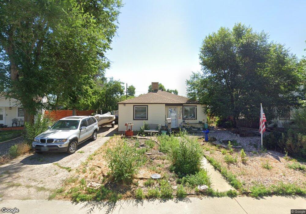
5580 Otis Ct Arvada, CO 80002
Estimated Value: $455,000 - $498,000
2
Beds
1
Bath
1,265
Sq Ft
$379/Sq Ft
Est. Value
About This Home
This home is located at 5580 Otis Ct, Arvada, CO 80002 and is currently estimated at $479,893, approximately $379 per square foot. 5580 Otis Ct is a home located in Jefferson County with nearby schools including Secrest Elementary School, North Arvada Middle School, and Arvada High School.
Ownership History
Date
Name
Owned For
Owner Type
Purchase Details
Closed on
Aug 13, 2025
Sold by
Gibson Todd Steven
Bought by
Corporate Properties Inc
Current Estimated Value
Purchase Details
Closed on
Oct 30, 2024
Sold by
Jefferson County Treasurer
Bought by
Buffalo Plains 22 Llc
Purchase Details
Closed on
Oct 9, 2018
Sold by
Gibson Dennis W
Bought by
Gibson Todd Steven and Gibson Angela
Purchase Details
Closed on
Dec 4, 2017
Sold by
Gibson Dennis W
Bought by
Gibson Dennis W
Create a Home Valuation Report for This Property
The Home Valuation Report is an in-depth analysis detailing your home's value as well as a comparison with similar homes in the area
Purchase History
| Date | Buyer | Sale Price | Title Company |
|---|---|---|---|
| Corporate Properties Inc | $10,000 | Wfg | |
| Buffalo Plains 22 Llc | $10,822,800 | None Listed On Document | |
| Gibson Todd Steven | $225,000 | None Available | |
| Gibson Dennis W | -- | None Available |
Source: Public Records
Tax History
| Year | Tax Paid | Tax Assessment Tax Assessment Total Assessment is a certain percentage of the fair market value that is determined by local assessors to be the total taxable value of land and additions on the property. | Land | Improvement |
|---|---|---|---|---|
| 2024 | $4,885 | $30,351 | $11,661 | $18,690 |
| 2023 | $4,885 | $30,351 | $11,661 | $18,690 |
| 2022 | $5,714 | $24,929 | $9,229 | $15,700 |
| 2021 | $2,482 | $25,646 | $9,494 | $16,152 |
| 2020 | $2,146 | $22,235 | $7,593 | $14,642 |
| 2019 | $2,117 | $22,235 | $7,593 | $14,642 |
| 2018 | $1,082 | $18,253 | $5,256 | $12,997 |
| 2017 | $991 | $18,253 | $5,256 | $12,997 |
| 2016 | $786 | $16,221 | $5,117 | $11,104 |
| 2015 | $1,297 | $16,221 | $5,117 | $11,104 |
| 2014 | $1,297 | $12,806 | $4,384 | $8,422 |
Source: Public Records
Map
Nearby Homes
- 6940 W 55th Place
- 6427 Grandview Ave Unit A & B
- 5465 Reed Ct
- 6500 Ralston Rd Unit A
- 5423 Saulsbury Ct
- 6950 W 54th Ave
- 6801 W 52nd Ave
- 6480 W 60th Ave
- 6840 W 60th Ave
- 7303 W 59th Ave
- 7313 W 60th Ave
- 6990 W 61st Ave
- 7707 Ralston Rd
- 7931 W 55th Ave Unit 112
- 5409 Zephyr Ct Unit 5409
- 5460 Allison St Unit 102
- 5320 Allison St Unit 106
- 7365 W 61st Ave
- 5419 Allison St Unit G
- 6105 W 49th Place