Estimated Value: $278,000 - $297,489
3
Beds
2
Baths
1,132
Sq Ft
$255/Sq Ft
Est. Value
About This Home
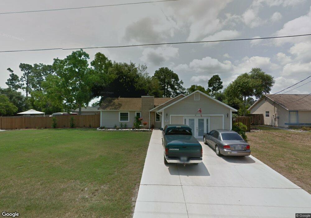
This home is located at 5585 Brandon St, Cocoa, FL 32927 and is currently estimated at $288,372, approximately $254 per square foot. 5585 Brandon St is a home located in Brevard County with nearby schools including Enterprise Elementary School, Space Coast Junior/Senior High School, and East Atlantic Prep of Brevard County.
Ownership History
Date
Name
Owned For
Owner Type
Purchase Details
Closed on
Apr 25, 2003
Sold by
Exline Deborah
Bought by
Exline Deborah and Gressman Steven
Current Estimated Value
Purchase Details
Closed on
Jun 12, 2001
Sold by
Exline Jeffrey S and Exline Deborah
Bought by
Exline Deborah
Purchase Details
Closed on
Aug 18, 1994
Sold by
Lindhorst Douglas C
Bought by
Exline Jeffrey S and Exline Deborah
Home Financials for this Owner
Home Financials are based on the most recent Mortgage that was taken out on this home.
Original Mortgage
$68,300
Interest Rate
8.65%
Create a Home Valuation Report for This Property
The Home Valuation Report is an in-depth analysis detailing your home's value as well as a comparison with similar homes in the area
Home Values in the Area
Average Home Value in this Area
Purchase History
| Date | Buyer | Sale Price | Title Company |
|---|---|---|---|
| Exline Deborah | -- | -- | |
| Exline Deborah | -- | -- | |
| Exline Jeffrey S | $67,000 | -- |
Source: Public Records
Mortgage History
| Date | Status | Borrower | Loan Amount |
|---|---|---|---|
| Previous Owner | Exline Jeffrey S | $68,300 |
Source: Public Records
Tax History Compared to Growth
Tax History
| Year | Tax Paid | Tax Assessment Tax Assessment Total Assessment is a certain percentage of the fair market value that is determined by local assessors to be the total taxable value of land and additions on the property. | Land | Improvement |
|---|---|---|---|---|
| 2025 | $1,241 | $93,730 | -- | -- |
| 2024 | $1,181 | $91,090 | -- | -- |
| 2023 | $1,181 | $86,530 | $0 | $0 |
| 2022 | $1,097 | $84,010 | $0 | $0 |
| 2021 | $1,089 | $81,570 | $0 | $0 |
| 2020 | $1,036 | $80,450 | $0 | $0 |
| 2019 | $971 | $78,650 | $0 | $0 |
| 2018 | $962 | $77,190 | $0 | $0 |
| 2017 | $952 | $75,610 | $0 | $0 |
| 2016 | $956 | $74,060 | $18,000 | $56,060 |
| 2015 | $967 | $73,550 | $15,000 | $58,550 |
| 2014 | $972 | $72,970 | $11,000 | $61,970 |
Source: Public Records
Map
Nearby Homes
- 7065 Hundred Acre Dr
- 6643 Emil Ave
- 6615 Dock Ave
- 6581 Bancroft Ave
- 7230 Venus Ave
- TBD Freeport Rd
- 5575 Curtis Blvd
- 5730 Friendly St
- 5155 Mayflower St
- 4650 N Highway 1 Hwy
- 5715 Fairbridge St
- 7635 Fringe Place
- 5090 Market St
- 6665 Addie Ave
- 7358 Crepe Myrtle Ct
- 00 Unknown
- 7545 Fringe Place
- 5149 Arlington Rd Unit 104
- 6105 Banyan St
- 7469 Hackberry Rd
- 5595 Brandon St
- 5565 Brandon St
- 5620 Brandon St
- 5615 Brandon St
- 5605 Brandon St
- 6960 Hundred Acre Dr
- 5580 Brandon St
- 5570 Brandon St
- 5590 Brandon St
- 6970 Hundred Acre Dr
- 6950 Hundred Acre Dr
- 5560 Brandon St
- 5555 Brandon St
- 5600 Brandon St
- 5630 Brandon St
- 6980 Hundred Acre Dr
- 6940 Hundred Acre Dr
- 6950 Pluto Ave
- 5585 Hemsing St
- 5610 Brandon St