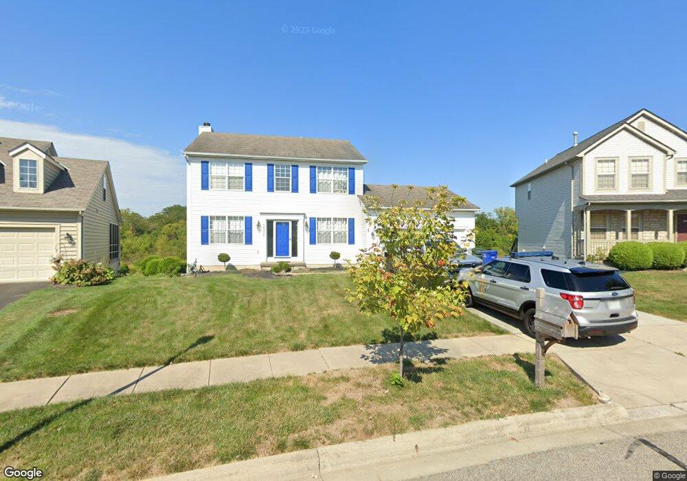
5585 Bunstine Dr Westerville, OH 43081
West Albany NeighborhoodEstimated Value: $458,000 - $485,000
4
Beds
3
Baths
1,868
Sq Ft
$249/Sq Ft
Est. Value
About This Home
This home is located at 5585 Bunstine Dr, Westerville, OH 43081 and is currently estimated at $465,949, approximately $249 per square foot. 5585 Bunstine Dr is a home located in Franklin County with nearby schools including Avalon Elementary School, Northgate Intermediate, and Woodward Park Middle School.
Ownership History
Date
Name
Owned For
Owner Type
Purchase Details
Closed on
Jun 18, 2004
Sold by
Guehl Matthew D and Guehl Janet S
Bought by
Thaxton Jermaine D and Young Tawanna L
Current Estimated Value
Purchase Details
Closed on
Jan 25, 2000
Sold by
Diyanni Brothers Inc
Bought by
Guehl D Matthew and Guehl Janet S
Home Financials for this Owner
Home Financials are based on the most recent Mortgage that was taken out on this home.
Original Mortgage
$174,150
Interest Rate
7.84%
Create a Home Valuation Report for This Property
The Home Valuation Report is an in-depth analysis detailing your home's value as well as a comparison with similar homes in the area
Home Values in the Area
Average Home Value in this Area
Purchase History
| Date | Buyer | Sale Price | Title Company |
|---|---|---|---|
| Thaxton Jermaine D | $244,000 | Chicago Tit | |
| Guehl D Matthew | $183,400 | Title First Agency Inc |
Source: Public Records
Mortgage History
| Date | Status | Borrower | Loan Amount |
|---|---|---|---|
| Previous Owner | Guehl D Matthew | $174,150 |
Source: Public Records
Tax History Compared to Growth
Tax History
| Year | Tax Paid | Tax Assessment Tax Assessment Total Assessment is a certain percentage of the fair market value that is determined by local assessors to be the total taxable value of land and additions on the property. | Land | Improvement |
|---|---|---|---|---|
| 2024 | $6,840 | $152,400 | $39,380 | $113,020 |
| 2023 | $6,752 | $152,390 | $39,375 | $113,015 |
| 2022 | $5,059 | $97,550 | $16,800 | $80,750 |
| 2021 | $5,068 | $97,550 | $16,800 | $80,750 |
| 2020 | $5,075 | $97,550 | $16,800 | $80,750 |
| 2019 | $4,865 | $80,190 | $14,000 | $66,190 |
| 2018 | $4,686 | $80,190 | $14,000 | $66,190 |
| 2017 | $4,862 | $80,190 | $14,000 | $66,190 |
| 2016 | $4,976 | $75,110 | $14,980 | $60,130 |
| 2015 | $4,517 | $75,110 | $14,980 | $60,130 |
| 2014 | $4,528 | $75,110 | $14,980 | $60,130 |
| 2013 | $2,127 | $71,540 | $14,280 | $57,260 |
Source: Public Records
Map
Nearby Homes
- 6455 Walnut Fork Dr Unit 6455
- 6501 Walnut Fork Dr Unit 6501
- 6498 Ash Rock Cir Unit 6498
- 5556 Falco Dr
- 5478 Albany Terrace Way Unit 1405
- 6221 Hudson Reserve Way
- 5600 Apothecary Way
- 5604 Apothecary Way Unit 4
- 5656 Apothecary Way Unit 2
- 6160 Albany Way Dr
- 5937 Seffner Dr
- 5655 Marshfield Dr
- 0 N Hamilton Rd
- 5288 Abby Gate Ave Unit 16
- 6813 Ridge Rock Dr Unit 14
- 5468 Nottinghamshire Ln
- 5450 Nottinghamshire Ln
- 6950 Harlem Rd
- 5396 Nottinghamshire Ln Unit 5396
- 5981 Niahway St Unit 57
- 5577 Bunstine Dr
- 5593 Bunstine Dr
- 5569 Bunstine Dr
- 6482 Glass Dr
- 6481 Glass Dr
- 5561 Bunstine Dr
- 5570 Bunstine Dr
- 6490 Glass Dr
- 5562 Bunstine Dr
- 6497 Glass Dr
- 5553 Bunstine Dr
- 6498 Glass Dr
- 5545 Bunstine Dr
- 5555 Connorwill Dr
- 5547 Connorwill Dr
- 5546 Bunstine Dr
- 5595 Connorwill Dr
- 5539 Connorwill Dr
- 5603 Connorwill Dr
- 5530 Bunstine Dr