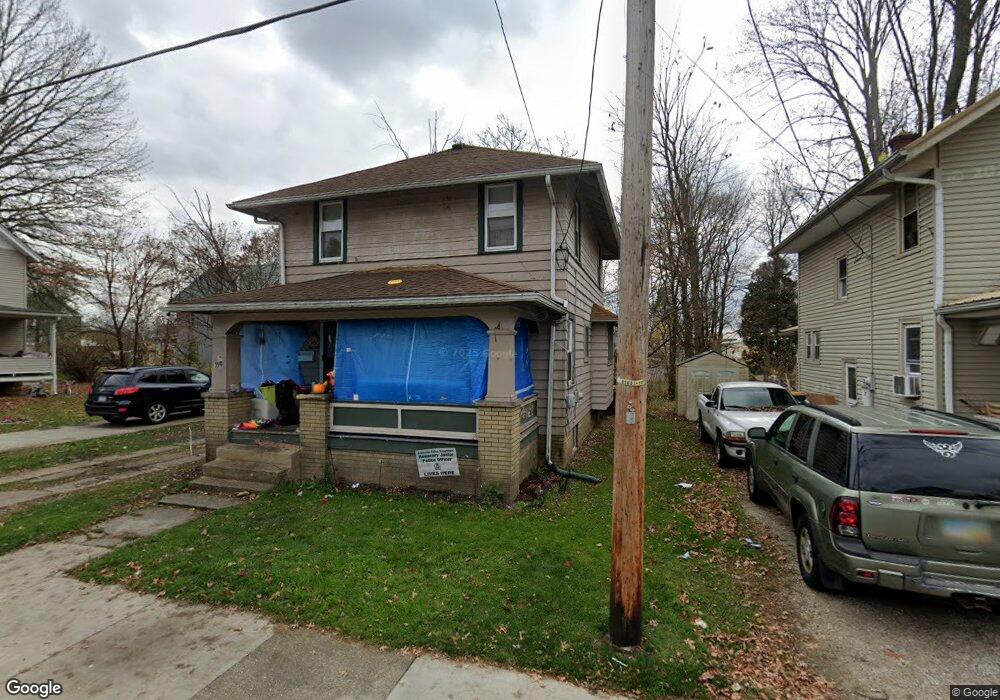
559 High St Wooster, OH 44691
Estimated Value: $124,599 - $166,000
3
Beds
2
Baths
1,152
Sq Ft
$126/Sq Ft
Est. Value
About This Home
This home is located at 559 High St, Wooster, OH 44691 and is currently estimated at $144,900, approximately $125 per square foot. 559 High St is a home located in Wayne County with nearby schools including Cornerstone Elementary School, Edgewood Middle School, and Wooster High School.
Ownership History
Date
Name
Owned For
Owner Type
Purchase Details
Closed on
Sep 9, 2019
Sold by
Sunflower Investments Llc
Bought by
Merillat Debra Joan and Debra Joan Merillat Revocable Trust
Current Estimated Value
Purchase Details
Closed on
Jan 27, 2005
Sold by
Gmac Mortgage Corp
Bought by
Sunflower Investments Llc
Home Financials for this Owner
Home Financials are based on the most recent Mortgage that was taken out on this home.
Original Mortgage
$45,000
Interest Rate
5.79%
Mortgage Type
Unknown
Purchase Details
Closed on
Sep 17, 2003
Sold by
Collins Richard A and Collins Betty M
Bought by
Fairbanks Capital Corp
Create a Home Valuation Report for This Property
The Home Valuation Report is an in-depth analysis detailing your home's value as well as a comparison with similar homes in the area
Home Values in the Area
Average Home Value in this Area
Purchase History
| Date | Buyer | Sale Price | Title Company |
|---|---|---|---|
| Merillat Debra Joan | -- | None Available | |
| Sunflower Investments Llc | $45,000 | Title First Agency Inc | |
| Gmac Mortgage Corp | -- | Title First Agency Inc | |
| Fairbanks Capital Corp | $55,000 | -- |
Source: Public Records
Mortgage History
| Date | Status | Borrower | Loan Amount |
|---|---|---|---|
| Previous Owner | Sunflower Investments Llc | $45,000 |
Source: Public Records
Tax History Compared to Growth
Tax History
| Year | Tax Paid | Tax Assessment Tax Assessment Total Assessment is a certain percentage of the fair market value that is determined by local assessors to be the total taxable value of land and additions on the property. | Land | Improvement |
|---|---|---|---|---|
| 2024 | $1,214 | $28,610 | $4,390 | $24,220 |
| 2023 | $1,214 | $28,610 | $4,390 | $24,220 |
| 2022 | $1,254 | $23,450 | $3,600 | $19,850 |
| 2021 | $1,293 | $23,450 | $3,600 | $19,850 |
| 2020 | $1,228 | $23,450 | $3,600 | $19,850 |
| 2019 | $1,140 | $20,870 | $3,540 | $17,330 |
| 2018 | $1,143 | $20,870 | $3,540 | $17,330 |
| 2017 | $1,137 | $20,870 | $3,540 | $17,330 |
| 2016 | $1,188 | $20,060 | $3,400 | $16,660 |
| 2015 | $1,167 | $20,060 | $3,400 | $16,660 |
| 2014 | $1,168 | $20,060 | $3,400 | $16,660 |
| 2013 | $1,142 | $19,330 | $2,880 | $16,450 |
Source: Public Records
Map
Nearby Homes
- 638 High St
- 554 Nold Ave
- 329 E Bowman St
- 548 Spring St
- 733 Spink St
- 423 N Market St
- 202 Palmer St
- 657 N Bever St
- 534 N Buckeye St
- 804 Belmont Ave
- 336 Spring St
- 708 N Bever St
- 227 N Walnut St
- 229 N Walnut St
- 406 N Walnut St
- 323 N Grant St
- 537 N Grant St
- 450 N Grant St
- 349 W North St
- 1029 E University St