Estimated Value: $254,000 - $285,000
3
Beds
2
Baths
1,066
Sq Ft
$253/Sq Ft
Est. Value
About This Home
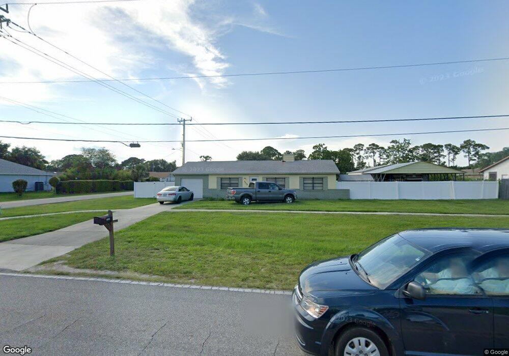
This home is located at 5590 Fay Blvd, Cocoa, FL 32927 and is currently estimated at $269,506, approximately $252 per square foot. 5590 Fay Blvd is a home located in Brevard County with nearby schools including Enterprise Elementary School, Space Coast Junior/Senior High School, and East Atlantic Prep of Brevard County.
Ownership History
Date
Name
Owned For
Owner Type
Purchase Details
Closed on
Jul 10, 2019
Sold by
Bohannan Raymond E
Bought by
Bohannan Raymond E
Current Estimated Value
Purchase Details
Closed on
Jul 31, 2001
Sold by
Rodriguez Randel L and Rodriguez Mary C
Bought by
Bohannan Raymond E
Home Financials for this Owner
Home Financials are based on the most recent Mortgage that was taken out on this home.
Original Mortgage
$72,512
Outstanding Balance
$28,163
Interest Rate
7.09%
Estimated Equity
$241,343
Create a Home Valuation Report for This Property
The Home Valuation Report is an in-depth analysis detailing your home's value as well as a comparison with similar homes in the area
Home Values in the Area
Average Home Value in this Area
Purchase History
| Date | Buyer | Sale Price | Title Company |
|---|---|---|---|
| Bohannan Raymond E | -- | None Available | |
| Bohannan Raymond E | $70,400 | -- |
Source: Public Records
Mortgage History
| Date | Status | Borrower | Loan Amount |
|---|---|---|---|
| Open | Bohannan Raymond E | $72,512 |
Source: Public Records
Tax History Compared to Growth
Tax History
| Year | Tax Paid | Tax Assessment Tax Assessment Total Assessment is a certain percentage of the fair market value that is determined by local assessors to be the total taxable value of land and additions on the property. | Land | Improvement |
|---|---|---|---|---|
| 2025 | $977 | $76,960 | -- | -- |
| 2024 | $959 | $74,800 | -- | -- |
| 2023 | $959 | $72,630 | $0 | $0 |
| 2022 | $903 | $70,520 | $0 | $0 |
| 2021 | $907 | $68,470 | $0 | $0 |
| 2020 | $874 | $67,530 | $0 | $0 |
| 2019 | $822 | $66,020 | $0 | $0 |
| 2018 | $824 | $64,790 | $0 | $0 |
| 2017 | $828 | $63,460 | $0 | $0 |
| 2016 | $835 | $62,160 | $18,000 | $44,160 |
| 2015 | $842 | $61,730 | $15,000 | $46,730 |
| 2014 | $846 | $61,240 | $11,000 | $50,240 |
Source: Public Records
Map
Nearby Homes
- 5460 Holden Rd
- 5446 Jamaica Rd
- 5720 Flint Rd
- 5275 Holden Rd
- 5946 Deer Ln
- 4650 N Highway 1 Hwy
- 5220 Holden Rd
- 5215 Holden Rd
- 5715 Fairbridge St
- 5575 Curtis Blvd
- 6325 Ainsworth Rd
- 6581 Bancroft Ave
- 5915 Akers St
- 6615 Dock Ave
- 5950 Ackard Ave
- 00 Unknown
- 6061 Banbury Ave
- 6365 Homestead Ave
- 6094 Cardiff Ave
- 5049 Jamaica Rd