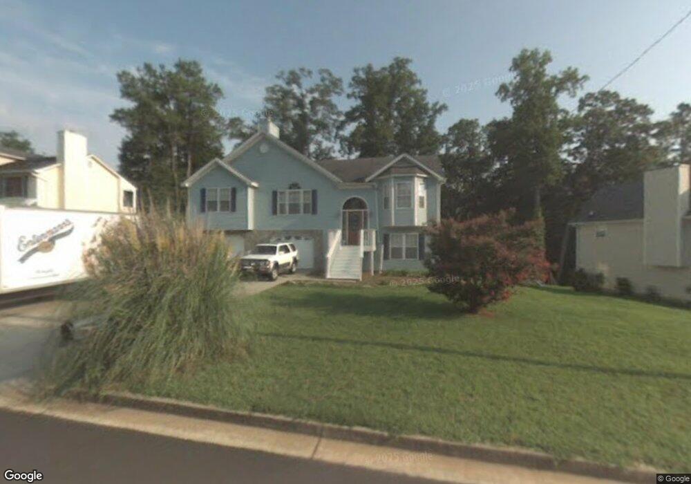
5595 Hillcrest Dr Union City, GA 30291
Estimated Value: $206,000 - $215,000
3
Beds
3
Baths
1,288
Sq Ft
$164/Sq Ft
Est. Value
About This Home
This home is located at 5595 Hillcrest Dr, Union City, GA 30291 and is currently estimated at $211,332, approximately $164 per square foot. 5595 Hillcrest Dr is a home located in Fulton County with nearby schools including Liberty Point Elementary School, Camp Creek Middle School, and Langston Hughes High School.
Ownership History
Date
Name
Owned For
Owner Type
Purchase Details
Closed on
Sep 4, 2018
Sold by
Wright Joseph D Estate
Bought by
Dinku Two Llc
Current Estimated Value
Purchase Details
Closed on
Oct 13, 1995
Sold by
Oxford Inc
Bought by
Wright Joseph Yolanda
Create a Home Valuation Report for This Property
The Home Valuation Report is an in-depth analysis detailing your home's value as well as a comparison with similar homes in the area
Home Values in the Area
Average Home Value in this Area
Purchase History
| Date | Buyer | Sale Price | Title Company |
|---|---|---|---|
| Dinku Two Llc | $71,000 | -- | |
| Wright Joseph Yolanda | $82,300 | -- |
Source: Public Records
Mortgage History
| Date | Status | Borrower | Loan Amount |
|---|---|---|---|
| Closed | Wright Joseph Yolanda | $0 |
Source: Public Records
Tax History Compared to Growth
Tax History
| Year | Tax Paid | Tax Assessment Tax Assessment Total Assessment is a certain percentage of the fair market value that is determined by local assessors to be the total taxable value of land and additions on the property. | Land | Improvement |
|---|---|---|---|---|
| 2025 | $1,075 | $81,800 | $20,240 | $61,560 |
| 2023 | $1,716 | $60,800 | $11,360 | $49,440 |
| 2022 | $1,600 | $60,800 | $11,360 | $49,440 |
| 2021 | $1,100 | $40,560 | $7,920 | $32,640 |
| 2020 | $1,113 | $40,040 | $7,800 | $32,240 |
| 2019 | $858 | $30,320 | $5,920 | $24,400 |
| 2018 | $401 | $24,240 | $3,240 | $21,000 |
| 2017 | $419 | $24,240 | $3,240 | $21,000 |
| 2016 | $487 | $27,960 | $5,160 | $22,800 |
| 2015 | $927 | $27,960 | $5,160 | $22,800 |
| 2014 | $282 | $16,920 | $2,080 | $14,840 |
Source: Public Records
Map
Nearby Homes
- 6320 Littleton Dr
- 0 Highpoint Rd Unit 10553938
- 000 Highpoint Rd
- 99 Highpoint Rd
- 4818 Sandstone Ln Unit 5
- 5135 Hilltop Dr
- 4812 Station Dr Unit 2
- 4811 Station Dr Unit 35
- 4817 Station Ln Unit 32
- 6030 Stonewall Dr
- Beaufort Plan at Stonewall Station
- Cecil Plan at The Enclave at Stonewall Station
- Nelson Plan at The Enclave at Stonewall Station
- Cooper Plan at Stonewall Station
- Cecil Plan at Stonewall Station
- Nelson Plan at Stonewall Station
- Kayla Plan at Stonewall Station
- 3317 Stonewall Ln Unit 71
- 4837 Station Ln
- 4811 Station Ln
- 5605 Hillcrest Dr
- 5585 Hillcrest Dr Unit 2
- 5575 Hillcrest Dr Unit 2
- 5615 Hillcrest Dr Unit 2
- 5245 Cochran Ct Unit 2
- 5570 Hillcrest Dr
- 4800 Cochran Ct
- 5590 Hillcrest Dr
- 5600 Hillcrest Dr
- 5565 Hillcrest Dr
- 5625 Hillcrest Dr
- 5580 Hillcrest Dr
- 5610 Hillcrest Dr
- 5560 Hillcrest Dr
- 5220 Cochran Ct Unit 2
- 5255 Cochran Ct
- 5555 Hillcrest Dr
- 5620 Hillcrest Dr
- 5550 Hillcrest Dr
- 5635 Hillcrest Dr