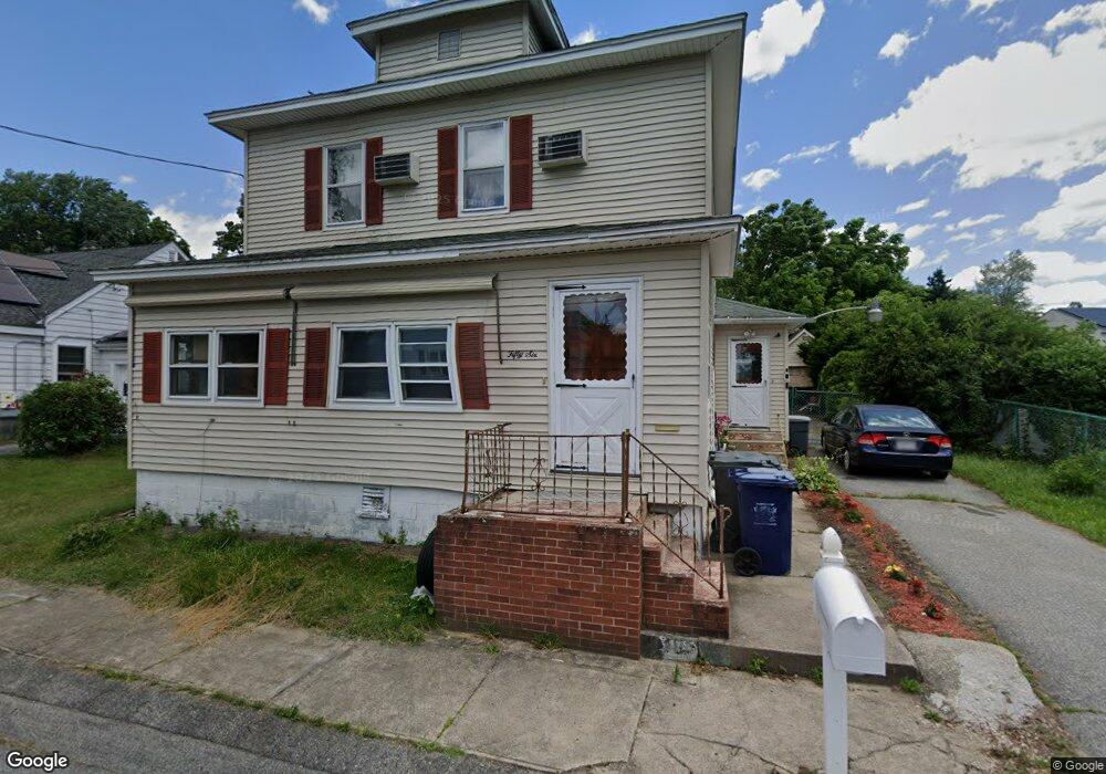
56 Desrosiers St Dracut, MA 01826
Estimated Value: $487,901 - $568,000
3
Beds
2
Baths
1,674
Sq Ft
$316/Sq Ft
Est. Value
About This Home
This home is located at 56 Desrosiers St, Dracut, MA 01826 and is currently estimated at $528,225, approximately $315 per square foot. 56 Desrosiers St is a home located in Middlesex County with nearby schools including George H. Englesby Elementary School, Richardson Middle School, and Dracut Senior High School.
Ownership History
Date
Name
Owned For
Owner Type
Purchase Details
Closed on
Aug 12, 1996
Sold by
Powell Andrew T and Powell Jill
Bought by
Gonzalo Romeo and Gonzalo Gonzolo Lolita
Current Estimated Value
Home Financials for this Owner
Home Financials are based on the most recent Mortgage that was taken out on this home.
Original Mortgage
$78,000
Interest Rate
8.24%
Mortgage Type
Purchase Money Mortgage
Purchase Details
Closed on
Oct 3, 1994
Sold by
Phoenix Rt
Bought by
Powell Andrew T and Morrow Jill K
Home Financials for this Owner
Home Financials are based on the most recent Mortgage that was taken out on this home.
Original Mortgage
$91,000
Interest Rate
8.5%
Mortgage Type
Purchase Money Mortgage
Purchase Details
Closed on
May 13, 1994
Sold by
Larose Walter and Larose Irene
Bought by
Premier Homes Inc
Create a Home Valuation Report for This Property
The Home Valuation Report is an in-depth analysis detailing your home's value as well as a comparison with similar homes in the area
Home Values in the Area
Average Home Value in this Area
Purchase History
| Date | Buyer | Sale Price | Title Company |
|---|---|---|---|
| Gonzalo Romeo | $118,000 | -- | |
| Powell Andrew T | $106,000 | -- | |
| Premier Homes Inc | $135,000 | -- |
Source: Public Records
Mortgage History
| Date | Status | Borrower | Loan Amount |
|---|---|---|---|
| Open | Premier Homes Inc | $140,000 | |
| Closed | Premier Homes Inc | $58,700 | |
| Closed | Premier Homes Inc | $78,000 | |
| Previous Owner | Premier Homes Inc | $91,000 |
Source: Public Records
Tax History Compared to Growth
Tax History
| Year | Tax Paid | Tax Assessment Tax Assessment Total Assessment is a certain percentage of the fair market value that is determined by local assessors to be the total taxable value of land and additions on the property. | Land | Improvement |
|---|---|---|---|---|
| 2025 | $4,086 | $403,800 | $152,300 | $251,500 |
| 2024 | $4,060 | $388,500 | $145,000 | $243,500 |
| 2023 | $3,883 | $335,300 | $126,100 | $209,200 |
| 2022 | $3,925 | $319,400 | $114,600 | $204,800 |
| 2021 | $3,789 | $291,200 | $104,200 | $187,000 |
| 2020 | $3,798 | $284,500 | $101,100 | $183,400 |
| 2019 | $3,490 | $253,800 | $96,300 | $157,500 |
| 2018 | $3,420 | $241,900 | $96,300 | $145,600 |
| 2017 | $3,215 | $241,900 | $96,300 | $145,600 |
| 2016 | $3,112 | $209,700 | $92,600 | $117,100 |
| 2015 | $2,970 | $198,900 | $92,600 | $106,300 |
| 2014 | $2,779 | $191,800 | $92,600 | $99,200 |
Source: Public Records
Map
Nearby Homes
- 20 Dean Ave
- 37 Beaudry St
- 363 Hildreth St Unit 11
- 349 Hildreth St Unit 16
- 345 Hildreth St Unit 14
- 195 Ludlam St
- 3 Hamel Place
- 2 Sutherland St
- 108 Billings St
- 87 Lilley Ave
- 49 Sparks St
- 100 Cass Ave Unit A13
- 81 Spring Park Ave
- 18 Stone St
- 39 Phoebe Ave
- 94 Hampson St
- 146 Gershom Ave
- 14 Endicott St
- 41 W L St
- 575 Beacon St