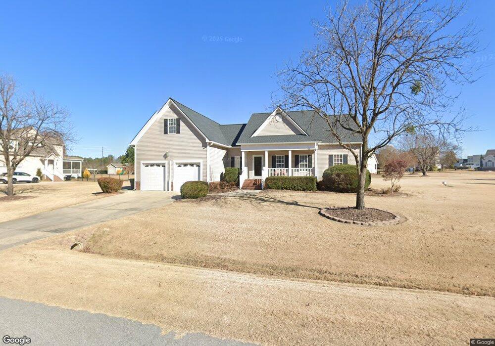
56 Granton Ct Clayton, NC 27520
Estimated Value: $379,330 - $420,000
3
Beds
2
Baths
1,962
Sq Ft
$203/Sq Ft
Est. Value
About This Home
This home is located at 56 Granton Ct, Clayton, NC 27520 and is currently estimated at $398,333, approximately $203 per square foot. 56 Granton Ct is a home located in Johnston County with nearby schools including Powhatan Elementary School, Riverwood Middle School, and Clayton High.
Ownership History
Date
Name
Owned For
Owner Type
Purchase Details
Closed on
Jun 26, 2007
Sold by
Gidco Inc
Bought by
Sunderland Joseph Dean and Sunderland Bonny Sue
Current Estimated Value
Home Financials for this Owner
Home Financials are based on the most recent Mortgage that was taken out on this home.
Original Mortgage
$60,000
Outstanding Balance
$37,247
Interest Rate
6.37%
Mortgage Type
Purchase Money Mortgage
Estimated Equity
$361,086
Create a Home Valuation Report for This Property
The Home Valuation Report is an in-depth analysis detailing your home's value as well as a comparison with similar homes in the area
Home Values in the Area
Average Home Value in this Area
Purchase History
| Date | Buyer | Sale Price | Title Company |
|---|---|---|---|
| Sunderland Joseph Dean | $213,000 | None Available |
Source: Public Records
Mortgage History
| Date | Status | Borrower | Loan Amount |
|---|---|---|---|
| Open | Sunderland Joseph Dean | $60,000 |
Source: Public Records
Tax History Compared to Growth
Tax History
| Year | Tax Paid | Tax Assessment Tax Assessment Total Assessment is a certain percentage of the fair market value that is determined by local assessors to be the total taxable value of land and additions on the property. | Land | Improvement |
|---|---|---|---|---|
| 2025 | $2,332 | $367,290 | $85,000 | $282,290 |
| 2024 | $1,625 | $200,570 | $33,000 | $167,570 |
| 2023 | $1,544 | $200,570 | $33,000 | $167,570 |
| 2022 | $1,585 | $200,570 | $33,000 | $167,570 |
| 2021 | $1,585 | $200,570 | $33,000 | $167,570 |
| 2020 | $1,645 | $200,570 | $33,000 | $167,570 |
| 2019 | $1,645 | $200,570 | $33,000 | $167,570 |
| 2018 | $0 | $202,380 | $39,000 | $163,380 |
| 2017 | $1,700 | $202,380 | $39,000 | $163,380 |
| 2016 | $1,700 | $202,380 | $39,000 | $163,380 |
| 2015 | $1,700 | $202,380 | $39,000 | $163,380 |
| 2014 | $1,700 | $202,380 | $39,000 | $163,380 |
Source: Public Records
Map
Nearby Homes
- 0000 U S 70 Highway Business W
- 3226 Powhatan Rd
- 111 Innsbruck Dr
- 3460 Powhatan Rd
- 108 Wilson Farm Ln
- 153 N Chubb Ridge
- 0 Powhatan Rd Unit 10126540
- 151 N Chubb Ridge
- 149 N Chubb Ridge
- 147 N Chubb Ridge
- 145 N Chubb Ridge
- 143 N Chubb Ridge
- 130 N Chubb Ridge
- 136 N Chubb Ridge
- 140 N Chubb Ridge
- 126 N Chubb Ridge
- Firefly Plan at Wilson's Walk - Single Family Homes
- Spectra Plan at Wilson's Walk - Single Family Homes
- Voyager Plan at Wilson's Walk - Single Family Homes
- Pulsar Plan at Wilson's Walk - Townhomes
- 86 Granton Ct
- 56 Slateford Dr
- 102 Slateford Dr
- 59 Granton Ct
- 24 Slateford Dr
- 102 Granton Ct
- 103 Granton Ct
- 103 Bilston Dr
- 87 Granton Ct
- 27 Bilston Dr
- 81 Slateford Dr
- 97 Slateford Dr
- 115 Slateford Dr
- 12 Bilston Dr
- 67 Slateford Dr
- 45 Slateford Dr
- 19 Slateford Dr
- 59 Bilston Dr
- 59 Bilston Dr
- 64 Bilston Dr