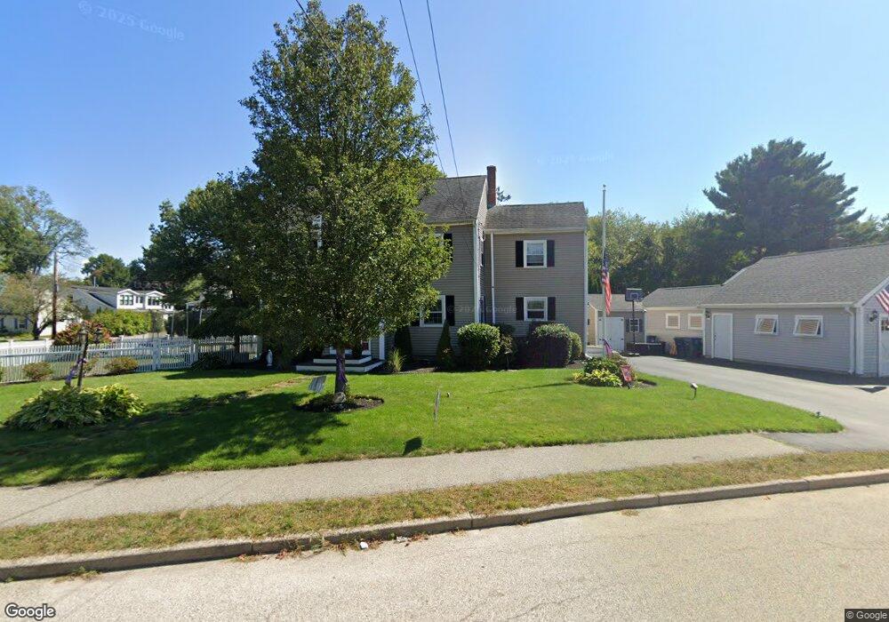
56 Howie Rd Braintree, MA 02184
North Braintree NeighborhoodEstimated Value: $732,000 - $903,000
3
Beds
1
Bath
1,492
Sq Ft
$526/Sq Ft
Est. Value
About This Home
This home is located at 56 Howie Rd, Braintree, MA 02184 and is currently estimated at $784,791, approximately $525 per square foot. 56 Howie Rd is a home located in Norfolk County with nearby schools including Braintree High School, Sacred Heart Elementary School, and South Shore SDA School.
Ownership History
Date
Name
Owned For
Owner Type
Purchase Details
Closed on
Aug 27, 2004
Sold by
Mclaughlin April A and Mclaughlin Michael H
Bought by
Moore Carolynn M and Moore Mark D
Current Estimated Value
Home Financials for this Owner
Home Financials are based on the most recent Mortgage that was taken out on this home.
Original Mortgage
$323,500
Outstanding Balance
$161,765
Interest Rate
6.02%
Mortgage Type
Purchase Money Mortgage
Estimated Equity
$623,026
Purchase Details
Closed on
Feb 27, 1996
Sold by
Leary Edward J Est and Leary John H
Bought by
Mclaughlin Michael H and Mclaughlin April A
Home Financials for this Owner
Home Financials are based on the most recent Mortgage that was taken out on this home.
Original Mortgage
$97,440
Interest Rate
7.04%
Mortgage Type
Purchase Money Mortgage
Create a Home Valuation Report for This Property
The Home Valuation Report is an in-depth analysis detailing your home's value as well as a comparison with similar homes in the area
Home Values in the Area
Average Home Value in this Area
Purchase History
| Date | Buyer | Sale Price | Title Company |
|---|---|---|---|
| Moore Carolynn M | $323,500 | -- | |
| Mclaughlin Michael H | $121,800 | -- |
Source: Public Records
Mortgage History
| Date | Status | Borrower | Loan Amount |
|---|---|---|---|
| Open | Moore Carolynn M | $323,500 | |
| Previous Owner | Mclaughlin Michael H | $97,440 |
Source: Public Records
Tax History
| Year | Tax Paid | Tax Assessment Tax Assessment Total Assessment is a certain percentage of the fair market value that is determined by local assessors to be the total taxable value of land and additions on the property. | Land | Improvement |
|---|---|---|---|---|
| 2025 | $6,780 | $679,400 | $349,400 | $330,000 |
| 2024 | $6,037 | $636,800 | $317,200 | $319,600 |
| 2023 | $5,736 | $587,700 | $285,000 | $302,700 |
| 2022 | $5,573 | $560,100 | $257,400 | $302,700 |
| 2021 | $5,158 | $518,400 | $232,600 | $285,800 |
| 2020 | $4,903 | $497,300 | $211,500 | $285,800 |
| 2019 | $4,598 | $455,700 | $202,300 | $253,400 |
| 2018 | $4,503 | $427,200 | $183,900 | $243,300 |
| 2017 | $4,380 | $407,800 | $174,700 | $233,100 |
| 2016 | $4,228 | $385,100 | $165,500 | $219,600 |
| 2015 | $3,865 | $349,100 | $137,900 | $211,200 |
| 2014 | $3,750 | $328,400 | $132,400 | $196,000 |
Source: Public Records
Map
Nearby Homes
- 63 Dickerman Ln
- 29 Joseph Rd
- 87 Walnut St
- 491 Washington St Unit 1
- 469-471 Washington St
- 9 Independence Ave Unit 307
- 20 Vine St
- 17 White Rd
- 342 Elm St
- 21 Totman St Unit 205
- 21 Totman St Unit 404
- 21 Totman St Unit 309
- 21 Totman St Unit 409
- 21 Totman St Unit 203
- 21 Totman St Unit 301
- 21 Totman St Unit PH-405
- 21 Totman St Unit PH-401
- 21 Totman St Unit 407
- 99 Verchild St
- 192 Federal Ave Unit B
Your Personal Tour Guide
Ask me questions while you tour the home.