


56 Noahs Lane Extension Norwalk, CT 06851
Woods Pond NeighborhoodEstimated payment $4,423/month
Total Views
1,030
2
Beds
3
Baths
2,003
Sq Ft
$337
Price per Sq Ft
Highlights
- Very Popular Property
- Colonial Architecture
- Property is near public transit
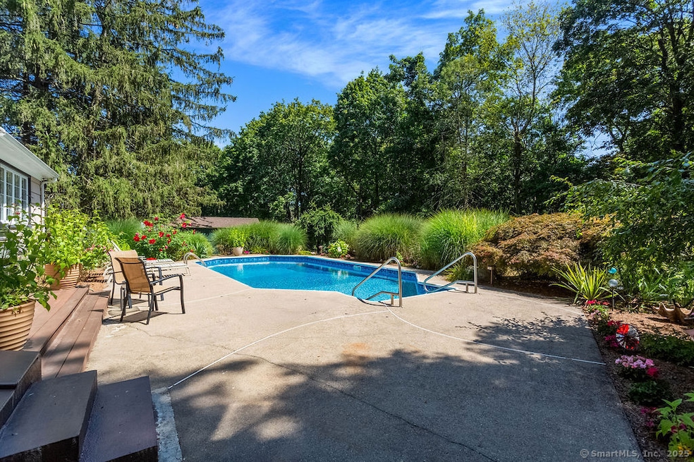
- In Ground Pool
- Deck
- Attic
About This Home
SECLUDED OASIS IN DESIRABLE CRANBURY NEIGHBORHOOD! Discover this charming home nestled on a private .91-acre lot that feels like your own personal retreat. Built in 1960 & thoughtfully updated, this lovely Colonial gem offers the perfect blend of character & modern convenience. Step inside to a soaring vaulted ceiling LR that creates an impressive sense of space & light. Beautiful hardwood flrs flow throughout the open-concept living & dining areas, enhanced by recessed lighting & ceiling fans for year-round comfort. A well-appointed Kitchen w/pantry storage & half bath/laundry rm completes the main level. 2nd flr features a lg Primary BD w/multiple closets & a 2nd BD w/ceiling fan. The finished basement provides excellent additional living space, recreation area, or home office potential including a half bath. Outside, your private paradise awaits with a sparkling inground swimming pool surrounded by mature landscaping & beautiful gardens. The screened porch offers the ideal spot for morning coffee or dining al fresco. The backyard is level, providing endless possibilities for outdoor activities & entertaining. The secluded setting ensures maximum privacy while remaining conveniently located in the highly sought-after Cranbury neighborhood. Tremendous expansion potential! The property features a 4-BD septic system & ample space for expansion, ideal for growing families or investors looking to maximize value. Portable generator hookup. Don't miss your perfect oasis!
Home Details
Home Type
- Single Family
Est. Annual Taxes
- $8,941
Year Built
- Built in 1960
Lot Details
- 0.91 Acre Lot
- Stone Wall
- Garden
- Property is zoned A2
Parking
- Parking Deck
Home Design
- Colonial Architecture
- Concrete Foundation
- Frame Construction
- Asphalt Shingled Roof
- Shingle Siding
Interior Spaces
- Central Vacuum
- Ceiling Fan
- 1 Fireplace
- Screened Porch
- Home Security System
Kitchen
- Electric Range
- Microwave
- Dishwasher
Bedrooms and Bathrooms
- 2 Bedrooms
Laundry
- Laundry on main level
- Dryer
- Washer
Attic
- Storage In Attic
- Pull Down Stairs to Attic
Finished Basement
- Heated Basement
- Basement Fills Entire Space Under The House
Pool
- In Ground Pool
- Vinyl Pool
Outdoor Features
- Deck
- Patio
- Exterior Lighting
- Shed
- Rain Gutters
Location
- Property is near public transit
- Property is near shops
Schools
- Cranbury Elementary School
- West Rocks Middle School
- Norwalk High School
Utilities
- Cooling System Mounted In Outer Wall Opening
- Baseboard Heating
- 60 Gallon+ Electric Water Heater
- Private Company Owned Well
Community Details
- Public Transportation
Listing and Financial Details
- Assessor Parcel Number 242793
Map
Create a Home Valuation Report for This Property
The Home Valuation Report is an in-depth analysis detailing your home's value as well as a comparison with similar homes in the area
Home Values in the Area
Average Home Value in this Area
Tax History
| Year | Tax Paid | Tax Assessment Tax Assessment Total Assessment is a certain percentage of the fair market value that is determined by local assessors to be the total taxable value of land and additions on the property. | Land | Improvement |
|---|---|---|---|---|
| 2025 | $10,091 | $425,060 | $236,750 | $188,310 |
| 2024 | $9,936 | $425,060 | $236,750 | $188,310 |
| 2023 | $8,193 | $328,160 | $188,710 | $139,450 |
| 2022 | $8,064 | $328,160 | $188,710 | $139,450 |
| 2021 | $6,862 | $328,160 | $188,710 | $139,450 |
| 2020 | $7,747 | $328,160 | $188,710 | $139,450 |
| 2019 | $7,481 | $328,160 | $188,710 | $139,450 |
| 2018 | $8,085 | $311,800 | $203,550 | $108,250 |
| 2017 | $7,802 | $311,800 | $203,550 | $108,250 |
| 2016 | $7,932 | $311,800 | $203,550 | $108,250 |
| 2015 | $7,125 | $311,800 | $203,550 | $108,250 |
| 2014 | $7,807 | $311,800 | $203,550 | $108,250 |
Source: Public Records
Property History
| Date | Event | Price | Change | Sq Ft Price |
|---|---|---|---|---|
| 08/21/2025 08/21/25 | For Sale | $675,000 | -- | $337 / Sq Ft |
Source: SmartMLS
Purchase History
| Date | Type | Sale Price | Title Company |
|---|---|---|---|
| Warranty Deed | $336,900 | -- | |
| Warranty Deed | $336,900 | -- |
Source: Public Records
Mortgage History
| Date | Status | Loan Amount | Loan Type |
|---|---|---|---|
| Open | $97,000 | Unknown | |
| Open | $275,000 | No Value Available | |
| Closed | $235,000 | No Value Available |
Source: Public Records
Similar Homes in Norwalk, CT
Source: SmartMLS
MLS Number: 24118066
APN: NORW-000005-000026-000019
Disclaimer: Certain information contained herein is derived from information provided by parties other than Homes.com. All information provided is deemed reliable, but is not guaranteed to be accurate and should be independently verified.
![]() IDX information is provided exclusively for personal, non-commercial use, and may not be used for any purpose other than to identify prospective properties consumers may be interested in purchasing. Information is deemed reliable but not guaranteed.
IDX information is provided exclusively for personal, non-commercial use, and may not be used for any purpose other than to identify prospective properties consumers may be interested in purchasing. Information is deemed reliable but not guaranteed.
Nearby Homes
- 613 Foxboro Dr Unit 613
- 515 Foxboro Dr Unit 515
- 400 Main Ave
- 150 Glover Ave
- 19 Baldwin Rd
- 300 Glover Ave Unit 101
- 300 Glover Ave Unit C221
- 300 Glover Ave Unit 440
- 399 Main Ave
- 1 Glover Ave
- 1 Glover Ave Unit 316
- 1 Glover Ave Unit 432
- 7 Margaret St Unit 2
- 50 Aiken St Unit 453
- 50 Aiken St Unit 123
- 21 Seir Hill Rd Unit 1
- 21 Seir Hill Rd Unit 3
- 289 Main Ave Unit 38
- 289 Main Ave Unit 40
- 289 Main Ave Unit 24