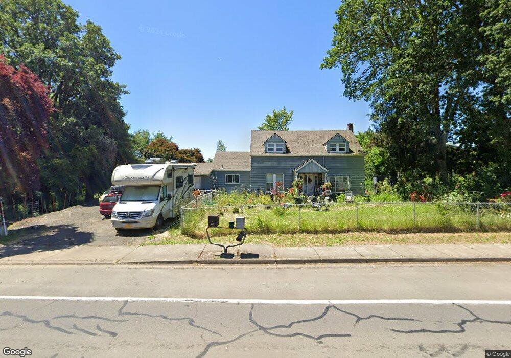
560 S 5th St Monroe, OR 97456
Estimated Value: $332,000 - $461,000
4
Beds
2
Baths
1,032
Sq Ft
$393/Sq Ft
Est. Value
About This Home
This home is located at 560 S 5th St, Monroe, OR 97456 and is currently estimated at $405,953, approximately $393 per square foot. 560 S 5th St is a home located in Benton County with nearby schools including Monroe Grade School and Monroe High School.
Ownership History
Date
Name
Owned For
Owner Type
Purchase Details
Closed on
Oct 30, 2020
Sold by
Frystak Mark and Moss Heather
Bought by
Moss Heather
Current Estimated Value
Home Financials for this Owner
Home Financials are based on the most recent Mortgage that was taken out on this home.
Original Mortgage
$201,000
Outstanding Balance
$177,562
Interest Rate
2.9%
Mortgage Type
VA
Estimated Equity
$228,391
Purchase Details
Closed on
Jun 24, 2004
Sold by
Mcmahon Donald L and Mcmahon Joyce D
Bought by
Frystak Mark and Frystak Heather
Home Financials for this Owner
Home Financials are based on the most recent Mortgage that was taken out on this home.
Original Mortgage
$150,000
Interest Rate
6.27%
Mortgage Type
VA
Purchase Details
Closed on
Jun 20, 1996
Bought by
Frystak Heather
Create a Home Valuation Report for This Property
The Home Valuation Report is an in-depth analysis detailing your home's value as well as a comparison with similar homes in the area
Purchase History
| Date | Buyer | Sale Price | Title Company |
|---|---|---|---|
| Moss Heather | -- | Cascade Title Co | |
| Frystak Mark | $150,000 | Fidelity Natl Title Co Of Or | |
| Frystak Heather | $100,000 | -- |
Source: Public Records
Mortgage History
| Date | Status | Borrower | Loan Amount |
|---|---|---|---|
| Open | Moss Heather | $201,000 | |
| Closed | Frystak Mark | $150,000 |
Source: Public Records
Tax History
| Year | Tax Paid | Tax Assessment Tax Assessment Total Assessment is a certain percentage of the fair market value that is determined by local assessors to be the total taxable value of land and additions on the property. | Land | Improvement |
|---|---|---|---|---|
| 2025 | $2,094 | $115,436 | -- | -- |
| 2024 | $2,094 | $112,074 | -- | -- |
| 2023 | $1,976 | $108,810 | $0 | $0 |
| 2022 | $1,925 | $105,641 | $0 | $0 |
| 2021 | $1,903 | $102,564 | $0 | $0 |
| 2020 | $1,961 | $99,577 | $0 | $0 |
| 2019 | $1,806 | $96,677 | $0 | $0 |
| 2018 | $1,944 | $93,861 | $0 | $0 |
| 2017 | $1,204 | $91,127 | $0 | $0 |
| 2016 | $1,167 | $88,473 | $0 | $0 |
| 2015 | $1,133 | $85,896 | $0 | $0 |
| 2014 | $1,085 | $83,394 | $0 | $0 |
| 2012 | -- | $78,607 | $0 | $0 |
Source: Public Records
Map
Nearby Homes
- 3 Orchard St
- 24618 Highway 99 W
- 24618 Highway 99 W
- 875 Shelby Way
- 475 S 10th St
- 991 Main St
- 0 8th Ave
- 194 Oak St
- 0 Oak St
- 26436 Coon Rd
- 710 N 8th St
- 26377 Cherry Creek Rd
- 26312 Shady Oak Dr
- 24880 Orchard Tract Rd
- 0 Hwy 99 W
- 15511AA016 W Highway 99
- 15511AA017 W Highway 99
- 96470 Highway 99 W
- 96470 Highway 99
- 0 Crandall
- 23800 Territorial Hwy
- 0 Territorial Rd Unit 5
- 0 Territorial Hwy
- 510 S 5th St
- 555 S 5th St
- 505 S 5th St
- 580 Unassigned Dr
- 575 S 5th St
- 580 Dragon Dr
- 579 S 5th St
- 657 S 5th St
- 661 S 5th St
- 726 S 5th St
- 430 S 5th St
- 725 S 5th St
- 380 S 5th St
- 24707 Territorial Rd
- 24703 Territorial Hwy
- 24716 Territorial Hwy
- 360 S 5th St
Your Personal Tour Guide
Ask me questions while you tour the home.