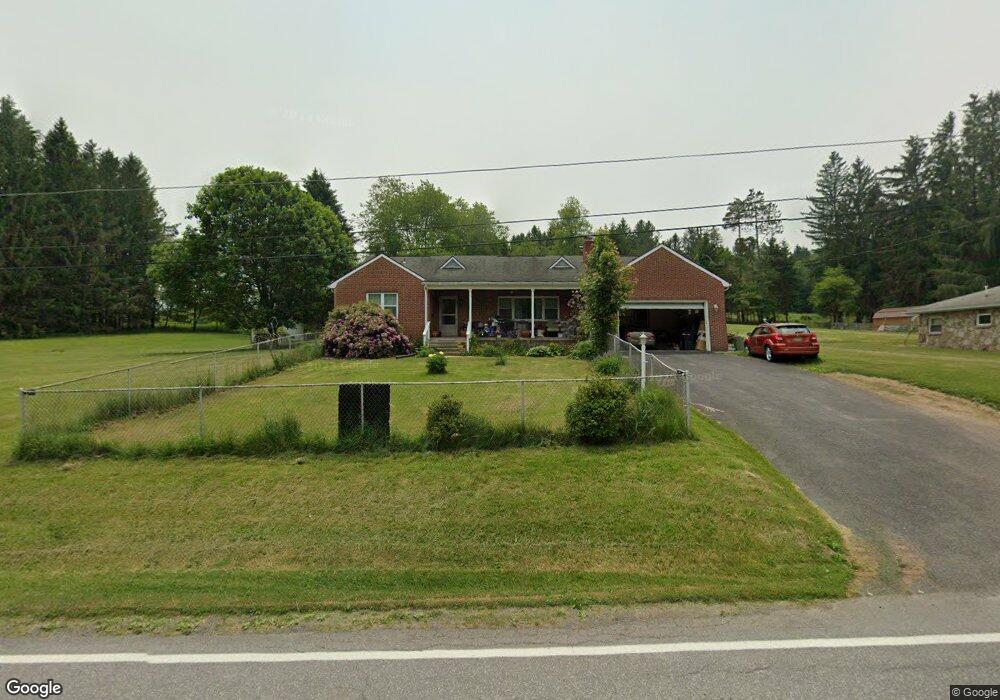
560 W Liberty St Oakland, MD 21550
Estimated Value: $221,943 - $311,000
--
Bed
2
Baths
1,715
Sq Ft
$149/Sq Ft
Est. Value
About This Home
This home is located at 560 W Liberty St, Oakland, MD 21550 and is currently estimated at $255,486, approximately $148 per square foot. 560 W Liberty St is a home located in Garrett County with nearby schools including Broad Ford Elementary School, Southern Middle School, and Southern Garrett High School.
Ownership History
Date
Name
Owned For
Owner Type
Purchase Details
Closed on
Dec 2, 2024
Sold by
Wolfe Pricilla D and Carrico Camille R
Bought by
Carrico Camille R and Carrico Gregory W
Current Estimated Value
Purchase Details
Closed on
May 5, 2020
Sold by
Wolfe Pricilla D
Bought by
Wolfe Pricilla D and Carrico Camille R
Create a Home Valuation Report for This Property
The Home Valuation Report is an in-depth analysis detailing your home's value as well as a comparison with similar homes in the area
Home Values in the Area
Average Home Value in this Area
Purchase History
| Date | Buyer | Sale Price | Title Company |
|---|---|---|---|
| Carrico Camille R | -- | None Listed On Document | |
| Wolfe Pricilla D | -- | None Available |
Source: Public Records
Tax History Compared to Growth
Tax History
| Year | Tax Paid | Tax Assessment Tax Assessment Total Assessment is a certain percentage of the fair market value that is determined by local assessors to be the total taxable value of land and additions on the property. | Land | Improvement |
|---|---|---|---|---|
| 2025 | $2,597 | $161,900 | $28,900 | $133,000 |
| 2024 | $2,348 | $151,867 | $0 | $0 |
| 2023 | $2,273 | $141,833 | $0 | $0 |
| 2022 | $2,162 | $131,800 | $28,700 | $103,100 |
| 2021 | $2,143 | $130,700 | $0 | $0 |
| 2020 | $2,125 | $129,600 | $0 | $0 |
| 2019 | $2,107 | $128,500 | $28,700 | $99,800 |
| 2018 | $2,022 | $128,500 | $28,700 | $99,800 |
| 2017 | $2,023 | $128,500 | $0 | $0 |
| 2016 | -- | $131,200 | $0 | $0 |
| 2015 | -- | $131,200 | $0 | $0 |
| 2014 | -- | $131,200 | $0 | $0 |
Source: Public Records
Map
Nearby Homes
- 0 Sam Snead Cir Unit 1 MDGA2010358
- 0 Crosby Dr Unit 64/65
- 62 Crosby Dr
- 0 N Hammond St
- 163 Mitchell Dr
- 315 Coolidge Ave
- 5202 Hutton Rd
- 163 Crestview Dr
- 511 E Green St
- 503 E Alder St
- 11 Sunset Dr
- 0 8th & Dennett Road St Unit MDGA2009886
- 611 E Oak St
- 13209 Garrett Hwy
- 627 Hamill St
- 1056 Sunrise Dr
- 0 Memorial Dr Unit MDGA2010668
- 111 Knoll Crest Heights Dr
- 609 Southern Pines Dr
- 127 S Oakhall Dr
- 570 W Liberty St
- 565 W Liberty St
- 572 W Liberty St
- 402 Leighton Dr
- 404 Leighton Dr
- 580 W Liberty St
- 555 W Liberty St
- 403 Leighton Dr
- 550 W Liberty St
- 421 Sonny Dr
- 551 W Liberty St
- 571 W Liberty St
- 420 Sonny Dr
- 408 Leighton Dr
- 423 Sonny Dr
- 429 Sam Snead Cir
- 407 Leighton Dr
- 422 Sonny Dr
- 427 Sam Snead Cir