Estimated Value: $351,000 - $403,000
4
Beds
2
Baths
2,256
Sq Ft
$165/Sq Ft
Est. Value
About This Home
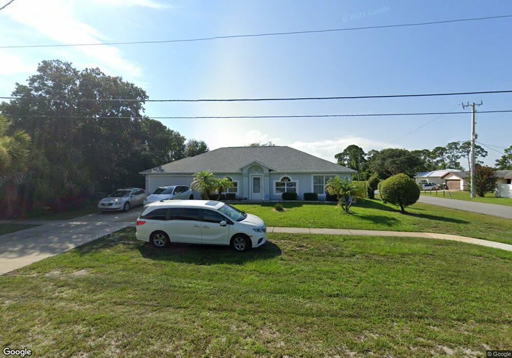
This home is located at 5600 Fay Blvd, Cocoa, FL 32927 and is currently estimated at $372,252, approximately $165 per square foot. 5600 Fay Blvd is a home located in Brevard County with nearby schools including Enterprise Elementary School, Space Coast Junior/Senior High School, and East Atlantic Prep of Brevard County.
Ownership History
Date
Name
Owned For
Owner Type
Purchase Details
Closed on
Feb 23, 2023
Sold by
Mcmahon Vincent J
Bought by
Vincent J Mcmahon Trust
Current Estimated Value
Purchase Details
Closed on
Jul 14, 2003
Sold by
Maronda Homes Inc Of Florida
Bought by
Mcmahon Vincent J and Mcmahon Judith A
Home Financials for this Owner
Home Financials are based on the most recent Mortgage that was taken out on this home.
Original Mortgage
$99,000
Interest Rate
5.2%
Purchase Details
Closed on
Jan 7, 2003
Sold by
Daley Lambert
Bought by
Maronda Homes Fl Inc
Purchase Details
Closed on
Dec 8, 1998
Sold by
Nationsbank Fl N A
Bought by
Daley Lambert and Daley Phyllis
Create a Home Valuation Report for This Property
The Home Valuation Report is an in-depth analysis detailing your home's value as well as a comparison with similar homes in the area
Home Values in the Area
Average Home Value in this Area
Purchase History
| Date | Buyer | Sale Price | Title Company |
|---|---|---|---|
| Vincent J Mcmahon Trust | $100 | -- | |
| Mcmahon Vincent J | $125,200 | Adnoram Title Company Inc | |
| Maronda Homes Fl Inc | $13,900 | -- | |
| Daley Lambert | $14,600 | -- |
Source: Public Records
Mortgage History
| Date | Status | Borrower | Loan Amount |
|---|---|---|---|
| Previous Owner | Mcmahon Vincent J | $99,000 |
Source: Public Records
Tax History
| Year | Tax Paid | Tax Assessment Tax Assessment Total Assessment is a certain percentage of the fair market value that is determined by local assessors to be the total taxable value of land and additions on the property. | Land | Improvement |
|---|---|---|---|---|
| 2025 | $1,684 | $118,920 | -- | -- |
| 2024 | $1,705 | $115,570 | -- | -- |
| 2023 | $1,705 | $112,210 | $0 | $0 |
| 2022 | $1,596 | $108,950 | $0 | $0 |
| 2021 | $1,596 | $105,780 | $0 | $0 |
| 2020 | $1,507 | $104,320 | $0 | $0 |
| 2019 | $1,442 | $101,980 | $0 | $0 |
| 2018 | $1,434 | $100,080 | $0 | $0 |
| 2017 | $1,425 | $98,030 | $0 | $0 |
| 2016 | $1,429 | $96,020 | $18,000 | $78,020 |
| 2015 | $1,447 | $95,360 | $15,000 | $80,360 |
| 2014 | $1,450 | $94,610 | $11,000 | $83,610 |
Source: Public Records
Map
Nearby Homes
- 5460 Holden Rd
- 5720 Flint Rd
- 6438 Hudson Rd
- 5355 Fay Blvd
- 5946 Deer Ln
- 5945 Coker Ave
- 5715 Fairbridge St
- 5221 Carrick Rd
- 5220 Holden Rd
- 5215 Holden Rd
- 6450 Ember Ave
- 6581 Bancroft Ave
- 6010 Fay Blvd
- 6365 Homestead Ave
- 5950 Ackard Ave
- 23-35-21-JX-B-2 Aruin St
- 6615 Dock Ave
- 6420 Homestead Ave
- 00 Unknown
- 6094 Cardiff Ave