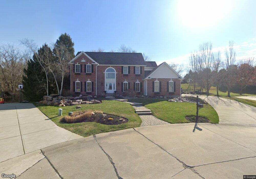
5600 Grinnell Ct Weldon Spring, MO 63304
Estimated Value: $636,000 - $726,000
4
Beds
4
Baths
2,940
Sq Ft
$233/Sq Ft
Est. Value
About This Home
This home is located at 5600 Grinnell Ct, Weldon Spring, MO 63304 and is currently estimated at $684,652, approximately $232 per square foot. 5600 Grinnell Ct is a home located in St. Charles County with nearby schools including Independence Elementary School, Francis Howell Middle School, and Francis Howell Union High School.
Ownership History
Date
Name
Owned For
Owner Type
Purchase Details
Closed on
Sep 21, 2007
Sold by
Price Holding Llc
Bought by
Saul John C and Saul Laurie A
Current Estimated Value
Home Financials for this Owner
Home Financials are based on the most recent Mortgage that was taken out on this home.
Original Mortgage
$326,710
Interest Rate
6.32%
Mortgage Type
Purchase Money Mortgage
Purchase Details
Closed on
Sep 15, 2006
Sold by
Saul John C and Saul Laurie A
Bought by
Price Holdings Llc
Create a Home Valuation Report for This Property
The Home Valuation Report is an in-depth analysis detailing your home's value as well as a comparison with similar homes in the area
Home Values in the Area
Average Home Value in this Area
Purchase History
| Date | Buyer | Sale Price | Title Company |
|---|---|---|---|
| Saul John C | $363,014 | Equity Land Title | |
| Price Holdings Llc | -- | Ust |
Source: Public Records
Mortgage History
| Date | Status | Borrower | Loan Amount |
|---|---|---|---|
| Closed | Saul John C | $326,710 |
Source: Public Records
Tax History
| Year | Tax Paid | Tax Assessment Tax Assessment Total Assessment is a certain percentage of the fair market value that is determined by local assessors to be the total taxable value of land and additions on the property. | Land | Improvement |
|---|---|---|---|---|
| 2025 | $6,376 | $115,466 | -- | -- |
| 2023 | $6,373 | $107,070 | $0 | $0 |
| 2022 | $5,936 | $92,636 | $0 | $0 |
| 2021 | $5,538 | $86,318 | $0 | $0 |
| 2020 | $5,111 | $77,092 | $0 | $0 |
| 2019 | $5,088 | $77,092 | $0 | $0 |
| 2018 | $5,002 | $72,454 | $0 | $0 |
| 2017 | $4,961 | $72,454 | $0 | $0 |
| 2016 | $4,448 | $62,544 | $0 | $0 |
| 2015 | $4,411 | $62,544 | $0 | $0 |
| 2014 | $4,217 | $57,995 | $0 | $0 |
Source: Public Records
Map
Nearby Homes
- 5527 Hennsley Cir
- 5534 Wavecrest Cir
- 0 Gutermuth Rd
- 323 Wildberry Ln
- 14 Walnut Hill Ct
- 828 Nancy Ln
- 102 Enclave Terrace Ct
- 1 Belcourt Cir
- 1005 Waldo Ln
- 1317 Auburn Hills Dr
- 265 Camelot Dr
- 1334 Auburn Hills Dr
- 0 Universal Design Prairie Bluff Unit MAR24041208
- 217 Bottlebrush Grove Ct
- 301 Switchgrass Landing Ln
- 114 Cottle Creek Way
- 3424 Capri Way
- 106 Cottle Creek Way
- 3624 Capri Way
- 110 Cottle Creek Way
- 5604 Grinnell Ct
- 5601 Grinnell Ct
- 5605 Grinnell Ct
- 5455 Westwood Dr
- 5608 Grinnell Ct
- 5451 Westwood Dr
- 5612 Grinnell Ct
- 5609 Grinnell Ct
- 5587 Hennsley Cir
- 5585 Hennsley Cir
- 5589 Hennsley Cir
- 5447 Westwood Dr
- 5616 Grinnell Ct
- 5583 E Hennsley Circle Ct
- 5613 Grinnell Ct
- 5591 Hennsley Cir
- 5593 Hennsley Cir
- 5620 Grinnell Ct
- 5579 E Hennsley Circle Ct
- 5621 Grinnell Ct
Your Personal Tour Guide
Ask me questions while you tour the home.