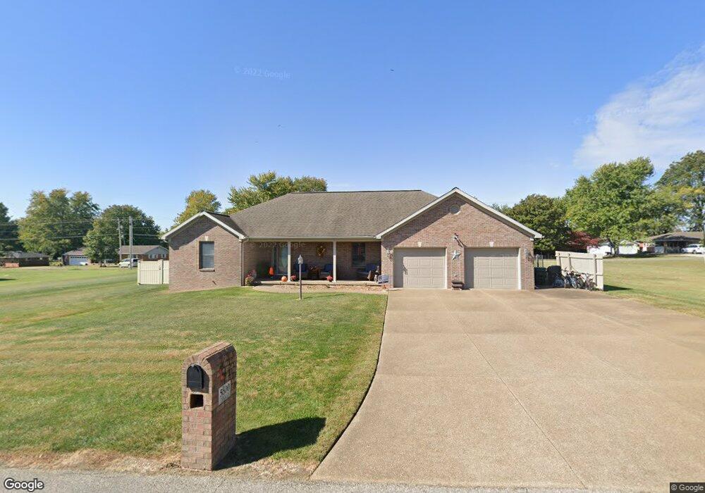
5600 Tahoe Dr Mount Vernon, IN 47620
Estimated Value: $286,000 - $413,000
3
Beds
3
Baths
1,815
Sq Ft
$205/Sq Ft
Est. Value
About This Home
This home is located at 5600 Tahoe Dr, Mount Vernon, IN 47620 and is currently estimated at $371,526, approximately $204 per square foot. 5600 Tahoe Dr is a home located in Posey County with nearby schools including Mount Vernon Junior High School, Mount Vernon High School, and St. Matthew Elementary School.
Ownership History
Date
Name
Owned For
Owner Type
Purchase Details
Closed on
May 2, 2011
Sold by
Veatch Roy A and Veatch Leslie A
Bought by
Fleener Barry W and Fleener Patricia L
Current Estimated Value
Home Financials for this Owner
Home Financials are based on the most recent Mortgage that was taken out on this home.
Original Mortgage
$140,000
Outstanding Balance
$97,204
Interest Rate
4.86%
Mortgage Type
New Conventional
Estimated Equity
$274,322
Purchase Details
Closed on
Dec 21, 2007
Sold by
Schelhorn Alan L and Schelhorn Laura
Bought by
Veatch Roy A and Veatch Leslie A
Home Financials for this Owner
Home Financials are based on the most recent Mortgage that was taken out on this home.
Original Mortgage
$166,076
Interest Rate
6.31%
Mortgage Type
New Conventional
Create a Home Valuation Report for This Property
The Home Valuation Report is an in-depth analysis detailing your home's value as well as a comparison with similar homes in the area
Home Values in the Area
Average Home Value in this Area
Purchase History
| Date | Buyer | Sale Price | Title Company |
|---|---|---|---|
| Fleener Barry W | -- | None Available | |
| Veatch Roy A | -- | Total Title Services Llc |
Source: Public Records
Mortgage History
| Date | Status | Borrower | Loan Amount |
|---|---|---|---|
| Open | Fleener Barry W | $140,000 | |
| Previous Owner | Veatch Roy A | $166,076 |
Source: Public Records
Tax History Compared to Growth
Tax History
| Year | Tax Paid | Tax Assessment Tax Assessment Total Assessment is a certain percentage of the fair market value that is determined by local assessors to be the total taxable value of land and additions on the property. | Land | Improvement |
|---|---|---|---|---|
| 2024 | $3,038 | $344,000 | $19,100 | $324,900 |
| 2023 | $2,461 | $288,900 | $19,100 | $269,800 |
| 2022 | $2,424 | $269,200 | $20,100 | $249,100 |
| 2021 | $2,105 | $238,900 | $28,000 | $210,900 |
| 2020 | $2,090 | $233,900 | $27,600 | $206,300 |
| 2019 | $2,002 | $228,100 | $27,600 | $200,500 |
| 2018 | $1,845 | $218,600 | $27,600 | $191,000 |
| 2017 | $1,737 | $217,700 | $27,500 | $190,200 |
| 2016 | $1,677 | $219,800 | $27,500 | $192,300 |
| 2014 | $1,537 | $216,400 | $27,500 | $188,900 |
| 2013 | $1,537 | $220,400 | $27,600 | $192,800 |
Source: Public Records
Map
Nearby Homes
- 5571 Red Lake Dr
- 5351 Cumberland Ct
- 5620 Red Lake Dr
- 1310 Mockingbird Ln
- 300 Roosevelt Dr
- 718 Davis Dr
- 316 Sunset Dr
- 1300 Harriett St
- 3200 Nation Rd
- 317 Kennedy Dr
- 317 E Lincoln Ave
- 1305 Locust St
- 405 Washington Ave
- 1240 Mulberry St
- 1230 Dereham Dr
- 433 Coronado Dr
- 444 Kennedy Dr
- 10800 Hwy 69 & Along Ohio River Rd
- 1235 E 3rd St
- 311 W Grant St
- 5551 Tahoe Dr Unit 9
- 9 Tahoe Dr Unit LOT
- 5 Tahoe Dr Unit LOT
- 5610 Tahoe Dr
- 5595 Tile Factory Rd
- 5601 Tahoe Dr
- 5575 Tile Factory Rd
- 5610 Tahoe Dr
- 5615 Tile Factory Rd
- 5539 Tahoe Dr
- 5551 Tahoe Dr
- 5611 Tahoe Dr
- 5641 Tile Factory Rd
- 5555 Tile Factory Rd
- 5661 Tile Factory Rd
- 5521 Red Lake Dr
- 5525 Tile Factory Rd
- 5625 Tahoe Dr
- 5550 Red Lake Dr
- 5681 Tile Factory Rd