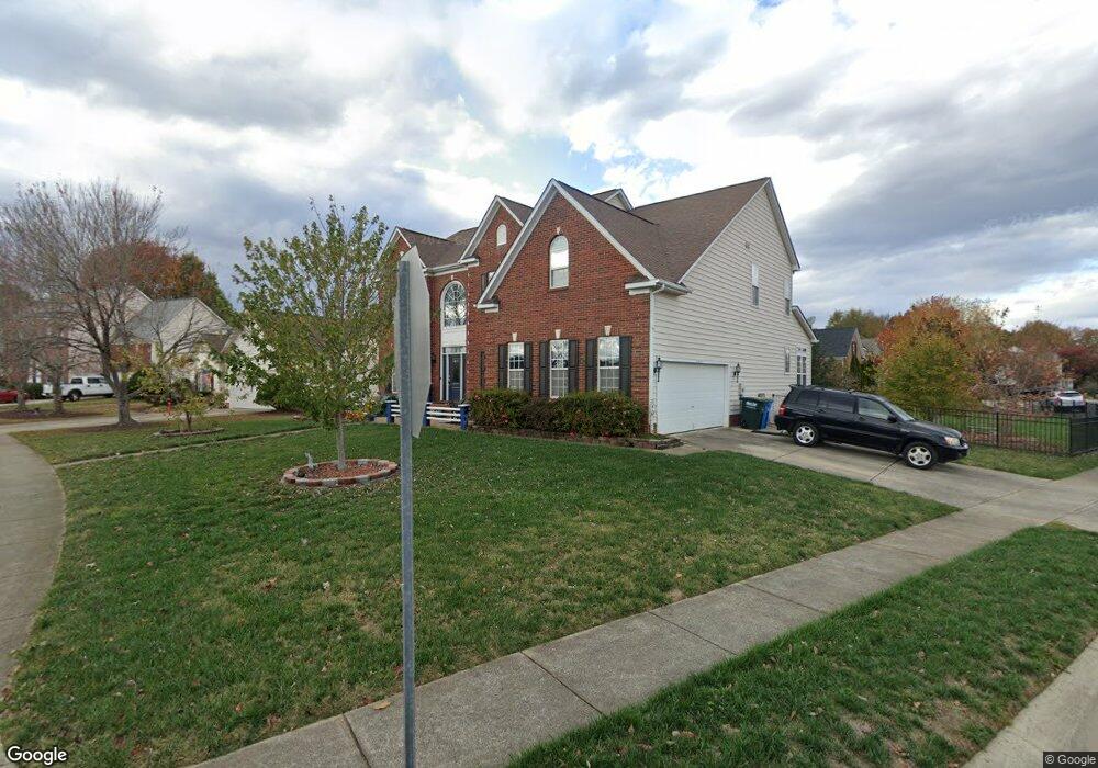
5601 Ginger Ln Indian Trail, NC 28079
Estimated Value: $553,000 - $570,000
--
Bed
3
Baths
3,432
Sq Ft
$163/Sq Ft
Est. Value
About This Home
This home is located at 5601 Ginger Ln, Indian Trail, NC 28079 and is currently estimated at $559,445, approximately $163 per square foot. 5601 Ginger Ln is a home located in Union County with nearby schools including Poplin Elementary School, Porter Ridge Middle School, and Porter Ridge High School.
Ownership History
Date
Name
Owned For
Owner Type
Purchase Details
Closed on
Dec 12, 2011
Sold by
Mazier Dania C and Tschirhart Michael T
Bought by
Tschirhart Michael T and Mazier Tschirhart Dania
Current Estimated Value
Home Financials for this Owner
Home Financials are based on the most recent Mortgage that was taken out on this home.
Original Mortgage
$297,236
Outstanding Balance
$204,187
Interest Rate
4.25%
Mortgage Type
FHA
Estimated Equity
$355,258
Purchase Details
Closed on
Jun 27, 2000
Sold by
Nvr Inc
Bought by
Tschirhart Michael T and Mazier Dania C
Home Financials for this Owner
Home Financials are based on the most recent Mortgage that was taken out on this home.
Original Mortgage
$239,400
Interest Rate
8.63%
Create a Home Valuation Report for This Property
The Home Valuation Report is an in-depth analysis detailing your home's value as well as a comparison with similar homes in the area
Home Values in the Area
Average Home Value in this Area
Purchase History
| Date | Buyer | Sale Price | Title Company |
|---|---|---|---|
| Tschirhart Michael T | -- | None Available | |
| Tschirhart Michael T | $252,000 | -- |
Source: Public Records
Mortgage History
| Date | Status | Borrower | Loan Amount |
|---|---|---|---|
| Open | Tschirhart Michael T | $297,236 | |
| Closed | Tschirhart Michael T | $239,400 |
Source: Public Records
Tax History Compared to Growth
Tax History
| Year | Tax Paid | Tax Assessment Tax Assessment Total Assessment is a certain percentage of the fair market value that is determined by local assessors to be the total taxable value of land and additions on the property. | Land | Improvement |
|---|---|---|---|---|
| 2025 | $4,176 | $632,200 | $0 | $0 |
| 2024 | $3,323 | $382,500 | $50,700 | $331,800 |
| 2023 | $3,163 | $379,000 | $50,700 | $328,300 |
| 2022 | $3,208 | $379,000 | $50,700 | $328,300 |
| 2021 | $3,161 | $379,000 | $50,700 | $328,300 |
| 2020 | $2,138 | $274,200 | $28,000 | $246,200 |
| 2019 | $2,868 | $274,200 | $28,000 | $246,200 |
| 2018 | $2,138 | $274,200 | $28,000 | $246,200 |
| 2017 | $2,940 | $274,200 | $28,000 | $246,200 |
| 2016 | $2,235 | $274,200 | $28,000 | $246,200 |
| 2015 | $2,270 | $274,200 | $28,000 | $246,200 |
| 2014 | $1,767 | $247,330 | $37,500 | $209,830 |
Source: Public Records
Map
Nearby Homes
- 5516 Beverly Dr
- 7215 Conifer Cir
- 6708 Mimosa St
- 6200 Trevor Simpson Dr
- 1541 Banham Dr
- 3903 Etheredge St
- 6825 Creft Cir Unit 49
- 3805 Balsam St Unit 321
- 6303 Margaret Ct Unit 82
- 3508 Mayhurst Dr
- 3802 Balsam St
- 3910 Faith Church Rd
- 3800 York Aly
- 7002 Creft Cir
- 3722 Society Ct
- 1010 Mapletree Ln
- 1092 Mapletree Ln
- 1073 Mapletree Ln
- 7607 Taft Place
- 0 Rose Dr Unit CAR4322172
- 4202 Mother Teresa Dr
- 5605 Ginger Ln
- 5600 Ginger Ln
- 4204 Mother Teresa Dr
- 5602 Ginger Ln
- 5604 Ginger Ln
- 5607 Ginger Ln
- 4102 Mother Teresa Dr
- 5610 Carol Ave
- 4206 Mother Teresa Dr
- 5609 Ginger Ln
- 5606 Ginger Ln
- 5613 Carol Ave
- 6318 Trevor Simpson Dr
- 5608 Carol Ave
- 6500 Courtland St
- 5611 Ginger Ln
- 5610 Ginger Ln
- 5610 Ginger Ln Unit 59
- 6316 Trevor Simpson Dr