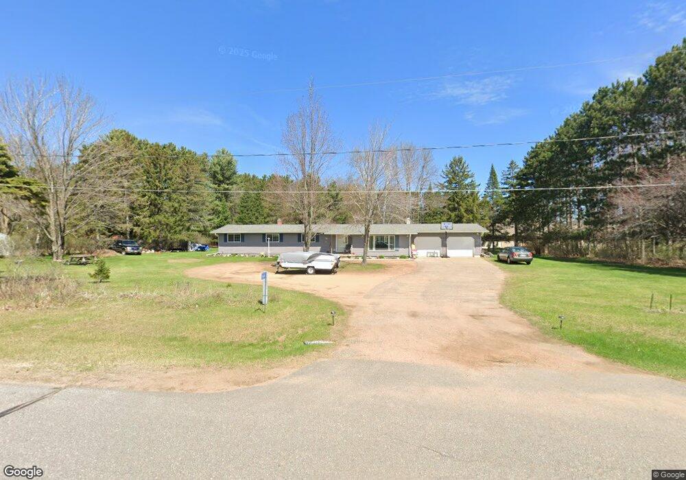
5606 Lombardy Dr Wausau, WI 54401
Estimated Value: $215,000 - $319,000
4
Beds
--
Bath
1,000
Sq Ft
$255/Sq Ft
Est. Value
About This Home
This home is located at 5606 Lombardy Dr, Wausau, WI 54401 and is currently estimated at $255,307, approximately $255 per square foot. 5606 Lombardy Dr is a home located in Marathon County with nearby schools including Stettin Elementary School, John Muir Middle School, and West High School.
Ownership History
Date
Name
Owned For
Owner Type
Purchase Details
Closed on
Oct 16, 2008
Sold by
Baehman Ciri K and Sorenson Craig W
Bought by
Sorenson Todd and Sorenson Sheila
Current Estimated Value
Home Financials for this Owner
Home Financials are based on the most recent Mortgage that was taken out on this home.
Original Mortgage
$62,000
Outstanding Balance
$40,246
Interest Rate
5.94%
Mortgage Type
Purchase Money Mortgage
Estimated Equity
$215,061
Purchase Details
Closed on
Jul 31, 2007
Sold by
Sorenson Harold W
Bought by
Sorenson Harold W and Harold W Sorenson Revocable Trust
Create a Home Valuation Report for This Property
The Home Valuation Report is an in-depth analysis detailing your home's value as well as a comparison with similar homes in the area
Home Values in the Area
Average Home Value in this Area
Purchase History
| Date | Buyer | Sale Price | Title Company |
|---|---|---|---|
| Sorenson Todd | $112,000 | None Available | |
| Sorenson Harold W | -- | None Available |
Source: Public Records
Mortgage History
| Date | Status | Borrower | Loan Amount |
|---|---|---|---|
| Open | Sorenson Todd | $62,000 |
Source: Public Records
Tax History Compared to Growth
Tax History
| Year | Tax Paid | Tax Assessment Tax Assessment Total Assessment is a certain percentage of the fair market value that is determined by local assessors to be the total taxable value of land and additions on the property. | Land | Improvement |
|---|---|---|---|---|
| 2024 | $2,969 | $195,200 | $29,100 | $166,100 |
| 2023 | $3,307 | $195,200 | $29,100 | $166,100 |
| 2022 | $3,024 | $195,200 | $29,100 | $166,100 |
| 2021 | $2,958 | $195,200 | $29,100 | $166,100 |
| 2020 | $2,587 | $141,100 | $24,800 | $116,300 |
| 2019 | $2,597 | $141,100 | $24,800 | $116,300 |
| 2018 | $2,697 | $141,100 | $24,800 | $116,300 |
| 2017 | $2,668 | $141,100 | $24,800 | $116,300 |
| 2016 | $2,524 | $141,100 | $24,800 | $116,300 |
| 2015 | $2,686 | $141,100 | $24,800 | $116,300 |
| 2014 | $2,566 | $141,100 | $24,800 | $116,300 |
Source: Public Records
Map
Nearby Homes
- 210 Bluestone Dr
- 303 Rimrock Rd
- 5713 Birchwood Dr
- 6007 Birchwood Dr
- 212 Windtree Dr
- 6603 Conner Davis Dr
- 6607 Morgan Creek Dr
- 6011 Stettin Dr
- 116 S 68th Ave
- 210 S 45th Ave
- 4615 Rib River Trail
- 206 N 44th Ave
- 10.80 Acres N 72nd Ave
- 310 Lisbeth Rd
- 3401 Christian Ave
- 145683 Flint Creek Cir
- 231747 Twin Fawn Trail
- 231781 Twin Fawn Trail
- 231752 Twin Fawn Trail
- 231816 Little Brook Ct
- 312 S 56th Ave Unit 312
- 5712 Lombardy Dr
- 5602 Lombardy Dr
- 314 S 56th Ave
- 310 S 56th Ave Unit 310
- 316 S 56th Ave Unit 316
- 308 S 56th Ave Unit 308
- 211 S 58th Ave
- 318 S 56th Ave
- 320 S 56th Ave
- 1234 S 58th Ave
- 306 S 56th Ave
- 304 S 56th Ave Unit 304
- 302 S 56th Ave
- 300 S 56th Ave Unit 300
- 327 S 56th Ave
- 319 S 56th Ave
- 311 S 56th Ave
- 307 S 56th Ave
- 201 S 58th Ave