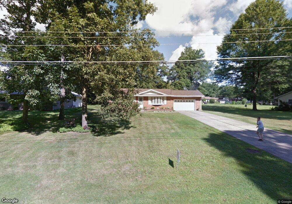
561 Bronson Dr Tallmadge, OH 44278
Estimated Value: $176,000 - $257,000
3
Beds
1
Bath
1,040
Sq Ft
$220/Sq Ft
Est. Value
About This Home
This home is located at 561 Bronson Dr, Tallmadge, OH 44278 and is currently estimated at $229,219, approximately $220 per square foot. 561 Bronson Dr is a home located in Summit County with nearby schools including Tallmadge Middle School, Tallmadge High School, and Steel Academy.
Ownership History
Date
Name
Owned For
Owner Type
Purchase Details
Closed on
Oct 7, 2010
Sold by
Gross Cecil Max and Gross Gwendolyn Regina
Bought by
Voleck Andrew R and Voleck Vickie L
Current Estimated Value
Home Financials for this Owner
Home Financials are based on the most recent Mortgage that was taken out on this home.
Original Mortgage
$87,000
Outstanding Balance
$57,440
Interest Rate
4.36%
Mortgage Type
New Conventional
Estimated Equity
$171,779
Create a Home Valuation Report for This Property
The Home Valuation Report is an in-depth analysis detailing your home's value as well as a comparison with similar homes in the area
Home Values in the Area
Average Home Value in this Area
Purchase History
| Date | Buyer | Sale Price | Title Company |
|---|---|---|---|
| Voleck Andrew R | $110,000 | Rts Group Inc |
Source: Public Records
Mortgage History
| Date | Status | Borrower | Loan Amount |
|---|---|---|---|
| Open | Voleck Andrew R | $87,000 |
Source: Public Records
Tax History Compared to Growth
Tax History
| Year | Tax Paid | Tax Assessment Tax Assessment Total Assessment is a certain percentage of the fair market value that is determined by local assessors to be the total taxable value of land and additions on the property. | Land | Improvement |
|---|---|---|---|---|
| 2025 | $3,067 | $70,669 | $18,767 | $51,902 |
| 2024 | $3,067 | $70,669 | $18,767 | $51,902 |
| 2023 | $3,067 | $70,669 | $18,767 | $51,902 |
| 2022 | $3,020 | $48,406 | $12,856 | $35,550 |
| 2021 | $3,034 | $48,406 | $12,856 | $35,550 |
| 2020 | $3,011 | $48,410 | $12,860 | $35,550 |
| 2019 | $3,114 | $44,760 | $12,860 | $31,900 |
| 2018 | $2,751 | $44,760 | $12,860 | $31,900 |
| 2017 | $2,403 | $44,760 | $12,860 | $31,900 |
| 2016 | $2,578 | $38,540 | $12,860 | $25,680 |
| 2015 | $2,403 | $38,680 | $12,860 | $25,820 |
| 2014 | $2,387 | $38,680 | $12,860 | $25,820 |
| 2013 | $2,354 | $38,840 | $12,860 | $25,980 |
Source: Public Records
Map
Nearby Homes
- 617 Northeast Ave
- 557 Wring Dr
- 0 Northeast Ave Unit 5114314
- 185 Reserve Dr
- 158 Minwood Ave
- 0 East Ave
- 313 Whittlesey Dr
- 213 Green Hill Dr
- 532 Beverly Dr
- 368 Knollwood Ave
- 1072 Carol Ln
- 243 S Munroe Rd
- 331 Southeast Ave
- 313 Southeast Ave
- 0 North Ave Unit 5116540
- 353 Southeast Ave
- 288 S Munroe Rd
- 206 Fawnwood Dr
- 617 North Ave
- 528 Fernwood Ave